Central Cordillera refers to the New Guinea Highlands.
The New Guinea Highlands, also known as the Central Range or Central Cordillera, are a chain of mountain ranges and intermountain river valleys, many of which support thriving agricultural communities, on the large island of New Guinea. The highlands run generally east-west the length of the island, which is divided politically between Indonesia in the west and Papua New Guinea in the east.
Cordillera Central, meaning central range in Spanish, may refer to the following mountain ranges:
The Cordillera Real is a chain of mountains in the Andes of Ecuador, the largest of them volcanic. They are continued by the Cordillera Central of Peru to the south and the Cordillera Central of Colombia to the north. The Cordillera Real includes Antisana, Cotopaxi, and Cayambe, while Chimborazo is in the Cordillera Occidental.
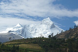
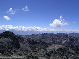
The Cordillera Blanca is a mountain range in Peru that is part of the larger Andes range and extends for 200 kilometres (124 mi) between 8°08' and 9°58'S and 77°00' and 77°52'W, in a northwesterly direction. It includes several peaks over 6,000 metres (19,690 ft) high and 722 individual glaciers. The highest mountain in Peru, Huascarán, at 6,768 metres (22,205 ft) high, is located there.
The Cordillera Central is a Bolivian mountain range that divides the three river basins in the country and also has the second highest peaks in Bolivia. It is rich in minerals and starts in the north with Chawpi Urqu and the three Palumanis that were in the south up to Zapaleri, forming a border with Chile and Argentina. The Cordillera Central is divided into three sections:
The Cordillera Central is the highest of the three branches of the Colombian Andes. The range extends from south to north dividing from the Colombian Massif in Cauca Department to the Serranía de San Lucas in Bolivar Departments. The highest peak is Nevado del Huila at 5,364 m (17,598 ft).
The Cordillera Central is part of the Andes in Peru. It extends in a northerly direction approximately between 11º 39’ and 12º 37’S and 75º 30’ and 76º 20’W for about 60 km to 100 km. It contains the Paryaqaqa (P), Yauyos (Y) and Pichqa Waqra (PW) mountain ranges. It is located in the Junín Region and in the Lima Region.
| This disambiguation page lists articles about distinct geographical locations with the same name. If an internal link led you here, you may wish to change the link to point directly to the intended article. |
Ancash is a region of northern Peru. It is bordered by La Libertad Region on the north, Huánuco and Pasco regions on the east, the Lima Region on the south, and the Pacific Ocean on the west. Its capital is the city of Huaraz, and its largest city and port is Chimbote. The name of the region originates from the Quechua word anqash, from anqas (blue) or from anka (eagle).
The American Cordillera is a chain of mountain ranges (cordilleras) that consists of an almost continuous sequence of mountain ranges that form the western "backbone" of North America, South America and West Antarctica. It is also the backbone of the volcanic arc that forms the eastern half of the Pacific Ring of Fire.
Huascarán National Park is a Peruvian national park that comprises most of the mountain range known as Cordillera Blanca which is part of the central Andes, in the region of Ancash. The park covers an area of 340.000 ha and is managed by the Peruvian Network of Protected Natural Areas: SERNANP. It was designated as a World Heritage Site in 1985 by UNESCO, is also a well-known mountaineering spot and harbors a unique biodiversity with plant species such as the Queen of the Andes, trees of the genera Polylepis and Buddleja, and animals such as spectacled bears, condors, vicunas and tarucas.
The Santa Valley is an inter-andean valley in the Ancash Region in the north-central highlands of Peru. Due to its location between two mountain ranges, it is known as Callejón de Huaylas, the Alley of Huaylas, whereas "Huaylas" refers to the territorial division's name during the Viceroyalty of Peru.
Cordillera Occidental is Spanish for "Western mountain". It may refer to:
Cordillera Oriental from the Spanish language meaning "Eastern range" may refer to:
Central Range, Central Mountains, or Central Mountain Range may refer to several ranges of mountains, including:
The Huaraz Province is one of twenty provinces of the Ancash Region in Peru. It was created on August 5, 1857 during the presidency of Ramón Castilla. Geographically, the province is located over the Callejón de Huaylas and the western slopes of the Cordillera Negra.
The Ichigkat Muja – Cordillera del Condor National Park is a protected area in Peru located in the region of Amazonas. It protects part of the Eastern Andes forests at the Cordillera del Condor mountain range.
Callejón is Spanish for "alley, side street" and may refer to:
Western Cordilleras can refer to
The Cordillera Carabaya lies in the Andes of Peru. It extends between 14°00' and 14°22'S and 69°38' and 70°19'W for about 75 km. It is located in the Puno Region, Carabaya Province, between the Vilcanota mountain range in the north-west and the Apolobamba mountain range in the south-east, north and north-east of Macusani.
The Huallanca mountain range (possibly from Quechua, wallanka mountain range; a cactus plant ; also called Chaupi Janca or Shicra Shicra lies in the Andes of Peru. It is located in the Ancash Region, Bolognesi Province. The Huallanca mountain range is a small range southeast of the Cordillera Blanca and north of the Huayhuash mountain range extending between 9°52' and 10°03'S and 76°58' and 77°04'W for about 19 km in a northeasterly direction.
The Pariacaca mountain range, also called Huarochirí mountain range lies in the Andes of Peru. It is located in the Junín Region, in the provinces of Jauja and Yauli, and in the Lima Region, in the provinces of Huarochirí and Yauyos. It is part of the Cordillera Central of Peru.
Ticlla or Qutuni, also called Tiklla or Tiqlla, is a 5,897-metre-high (19,347 ft) mountain in the Cordillera Central in the Andes of Peru. Strictly speaking the popular name Ticlla refers to a group of peaks of the Qutuni-Ticlla cirque. The highest mountain of the massif is named Qutuni. It lies in a sub-range of the Cordillera Central named Pichqa Waqra.