
Cranberries are a group of evergreen dwarf shrubs or trailing vines in the subgenus Oxycoccus of the genus Vaccinium. In Britain, cranberry may refer to the native species Vaccinium oxycoccos, while in North America, cranberry may refer to Vaccinium macrocarpon. Vaccinium oxycoccos is cultivated in central and northern Europe, while Vaccinium macrocarpon is cultivated throughout the northern United States, Canada and Chile. In some methods of classification, Oxycoccus is regarded as a genus in its own right. They can be found in acidic bogs throughout the cooler regions of the Northern Hemisphere.

Wareham is a town in Plymouth County, Massachusetts, United States. As of the 2010 census, the town had a population of 21,822. Wareham has long been recognized as the western point of Cape Cod.
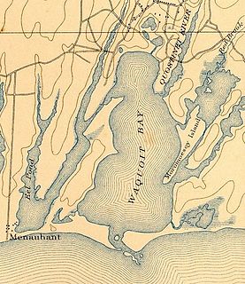
Waquoit Bay is a public national estuary, which is typically used as a research reserve. It is a part of Nantucket Sound and is located on the southern shore of Cape Cod in Massachusetts, USA. This bay forms the border of the towns of Falmouth, Massachusetts and Mashpee.
The East Brookfield River is a 2.4-mile-long (3.9 km) river in Massachusetts that heads at Lake Lashaway in East Brookfield at an elevation of 614 feet (187 m) above sea level. It continues to Quaboag Pond, at an elevation of 594 feet (181 m).

The Seven Mile River or Sevenmile River is a 9.6-mile-long (15.4 km) stream in central Massachusetts. It heads at Browning Pond, at the Oakham and Spencer border, and travels south through Spencer, following a short distance from State Route 31. It crosses under Route 31 the highway becomes Pleasant Street, then continues south along Old Meadow Road and under State Route 9 near the junction of State Route 49. It then parallels Route 9 to its south until it joins the East Brookfield River between Lake Lashaway and Quaboag Pond.

The Sippican River is a short river in Massachusetts, United States.

The Quashnet River, also known as Quoshnet River or Moonakis River, is a 5.1-mile-long (8.2 km) estuary in Falmouth, Massachusetts on Cape Cod. Its area is about 1-square-mile (2.6 km2).
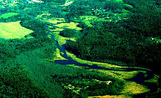
The Childs River, also known as Child's River, is a 5.1-mile-long (8.2 km) river near Falmouth, Massachusetts on Cape Cod. Its drainage area is about 1-square-mile (2.6 km2). It has been heavily impacted by the development of cranberry bogs in its upper reaches.

The Wankinco River is a 7.3-mile-long (11.7 km) river in eastern Massachusetts, United States. It is a tributary of the Wareham River, which drains into Buzzards Bay.
The Coonamesset River is a 3.1-mile-long (5.0 km) river in Falmouth, Massachusetts on Cape Cod. The river has its headwaters in Coonamessett Pond, flows generally south to Great Pond estuary, and empties into the Vineyard Sound just east of Falmouth Heights. The river is shallow running through old glacial deposits of sand and gravel, and hosts a major New England herring run. Red maple swamps border the river along its headwaters and at its mouth where it runs through private property and Town land, while along the lower river it is largely flanked by commercial cranberry bogs that run to the rivers edge.

The Mattapoisett River is an 11.6-mile-long (18.7 km) river in southeastern Massachusetts, in the United States.

The Weweantic River is a 17.0-mile-long (27.4 km) river in southeastern Massachusetts. Its name means "crooked" or "wandering stream" in the Wampanoag language.
Russell Millpond, also known as Russell Mill Pond, is a 42-acre (170,000 m2) pond in the Chiltonville village of Plymouth, Massachusetts, United States. Fed by springs and water from cranberry bogs, the outflow of the pond is the Eel River. The water quality is impaired due to non-native aquatic plants in the pond.
Crossman Pond is a 15-acre (61,000 m2) pond in Kingston, Massachusetts, located off Wapping Road and South Street. The pond is hydro logically associated with a cranberry bog operation located to the west of the pond. The outflow is an unnamed stream that feeds the cranberry bog, ultimately leading to Fountainhead Brook, a tributary of the Jones River. The water quality is impaired due to non-native aquatic plants.
Harrobs Corner Bog Pond is a 16-acre (65,000 m2) pond in Plympton, Massachusetts. The pond is located in the North Plympton section of the town north of Harrobs Corner off Route 106 and Lake Street, and south of Silver Lake village. The pond is hydrologically associated with a cranberry bog operation located to the northeast of the pond. An unnamed brook heading south toward Jones River Creek, a tributary of the Jones River, is the outflow of the pond. The water quality is impaired due to non-native aquatic plants in the pond.
Upper Chandler Pond is a 10-acre (40,000 m2) pond in Duxbury and Pembroke, Massachusetts. The pond is located north of Lower Chandler Pond and east of West Chandler Pond. The pond is the headwaters to Pine Brook, a tributary of the Jones River. The pond is hydro logically associatied with two nearby cranberry bogs. The water quality is impaired due to non-native aquatic plants and non-native fish in the pond.
West Chandler Pond is a 12-acre (49,000 m2) pond in Pembroke, Massachusetts. The pond is located west of Upper Chandler Pond and northwest of Pembroke's easternmost Town Forest. The pond is hydrologically associated with a cranberry bog located to the southeast. An unnamed stream that runs through the cranberry bog and ultimately leads to Pine Brook, a tributary of the Jones River, is the outflow of the pond.

The Cranberry Wilderness is a 47,815-acre (19,350 ha) U.S. wilderness area in the Monongahela National Forest of southeast West Virginia, United States. Its name derives from the nearby Cranberry Glades as well as from the Cranberry River and Cranberry Mountain. In addition to being wilderness, it is a designated black bear sanctuary.

Spencer State Forest is a Massachusetts state forest and recreation reserve located in the town of Spencer, managed by the Massachusetts Department of Conservation and Recreation. The 92 mile (148 km) Midstate Trail passes through the state forest. The Commonwealth of Massachusetts also conducts logging in some parts of the property.

Waquoit Bay National Estuarine Research Reserve (WBNERR) encompasses open waters, barrier beaches, marshlands and uplands on the south shore of Cape Cod in the towns of Falmouth and Mashpee. The park is managed by the Department of Conservation and Recreation (DCR) and the National Oceanic and Atmospheric Administration.


