Crocker Mountain (Maine)

Last updated
Crocker Mountain

Crocker Mt centre.JPG

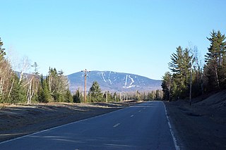
Crocker Mountain (center) seen from Sugarloaf ski resort
Highest point
Elevation 4,229 ft (1,289 m)
Prominence 1,214 ft (370 m) [1]
Listing New England 4000 footers
Coordinates 45°02′50″N70°22′58″W / 45.047167°N 70.382833°W / 45.047167; -70.382833 Coordinates: 45°02′50″N70°22′58″W / 45.047167°N 70.382833°W / 45.047167; -70.382833 [2]
Geography
USA Maine location map.svg
Red triangle with thick white border.svg
Crocker Mountain
Topo map USGS Black Nubble

Crocker Mountain is a 4,228 ft (1,289 m) peak located in Carrabassett Valley, Franklin County, Maine, in the United States. [3] Crocker Mountain is the fourth highest mountain in the state after the Katahdins (Baxter and Hamlin peaks) and Sugarloaf Mountain, and is part of the Appalachian Mountains. Crocker Mountain is traversed by the Appalachian Trail (AT), a 2,170 mi (3,490 km) National Scenic Trail from Georgia to Maine.

Carrabassett Valley, Maine Town in Maine, United States

Carrabassett Valley is a town in Franklin County, Maine, United States. The population was 761 at the 2010 census.

Franklin County, Maine County in the United States

Franklin County is a county located in the state of Maine, in the United States. As of the 2010 census, the population was 30,768, making it the second-least populous county in Maine. Its county seat is Farmington. The county was established on May 9, 1838 and named for Benjamin Franklin.

Maine State of the United States of America

Maine is a state in the New England region of the northeastern United States. Maine is the 12th smallest by area, the 9th least populous, and the 38th most densely populated of the 50 U.S. states. It is bordered by New Hampshire to the west, the Atlantic Ocean to the southeast, and the Canadian provinces of New Brunswick and Quebec to the northeast and northwest respectively. Maine is the easternmost state in the contiguous United States, and the northernmost state east of the Great Lakes. It is known for its jagged, rocky coastline; low, rolling mountains; heavily forested interior; and picturesque waterways, as well as its seafood cuisine, especially lobster and clams. There is a humid continental climate throughout most of the state, including in coastal areas such as its most populous city of Portland. The capital is Augusta.

Contents

A glacial cirque called "Crocker Cirque" is located between the main summit and the lower summit of South Crocker Mountain. Crocker Cirque contains a small pond and can be reached via the Appalachian Trail.

South Crocker Mountain mountain in United States of America

South Crocker Mountain is a mountain located in Franklin County, Maine. South Crocker Mountain is flanked to the north by Crocker Mountain, and to the southwest by Mount Redington.

Brooks on the east side of Crocker Mountain feed the South Branch of the Carrabassett River, which flows into the Kennebec River, and into the Gulf of Maine. The northwest side of Crocker drains into Stoney Brook, then into Stratton Brook, Flagstaff Lake, and the Dead River, another tributary of the Kennebec. The southwest side of Crocker drains into Nash Stream, then into the South Branch of the Dead River.

Carrabassett River river in the United States of America

The Carrabassett River, a tributary of the Kennebec River, is located in Franklin County and Somerset County, Maine, in the United States. It rises near Sugarloaf Mountain, east of Rangeley Lake, and runs for 33.8 miles (54.4 km), flowing southeast past Kingfield and joining the Kennebec River in the town of Anson.

Kennebec River river in Maine, United States

The Kennebec River is a 170-mile-long (270 km) river within the U.S. state of Maine.

Gulf of Maine A large gulf of the Atlantic Ocean on the east coast of North America

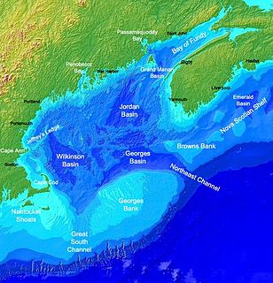
The Gulf of Maine is a large gulf of the Atlantic Ocean on the east coast of North America. It is bounded by Cape Cod at the eastern tip of Massachusetts in the southwest and by Cape Sable Island at the southern tip of Nova Scotia in the northeast. The gulf includes the entire coastlines of the U.S. states of New Hampshire and Maine, as well as Massachusetts north of Cape Cod, and the southern and western coastlines of the Canadian provinces of New Brunswick and Nova Scotia, respectively.

See also

Related Research Articles

Mount Kelsey is a mountain located in the western portion of Millsfield, New Hampshire. The western slopes of the mountain are contained within the township of Erving's Location, New Hampshire. The summit is occupied by part of the Granite Reliable Wind Farm, with road access from the Phillips Brook watershed to the south.

The Western Maine Mountains region spans most of Maine's western border with New Hampshire. A small part of the scenic White Mountain National Forest is located in this area. This is essentially all of Oxford County and northern Franklin, York and Cumberland Counties. Notable towns include Bethel, Bridgton, Oxford, Rangeley, and Rumford. Many of the state's highest peaks are located in the region, although the highest, Mount Katahdin, is not.

Saddleback Mountain (Rangeley, Maine) mountain in Maine, United States of America

Saddleback Mountain is a mountain located in Sandy River Plantation, Franklin County, Maine, near the resort town of Rangeley. Saddleback is one of the highest mountains in the State of Maine, and one of the fourteen with more than 2,000 ft (610 m) of topographic prominence. The mountain is the site of Saddleback ski resort.

Sugarloaf Mountain (Franklin County, Maine) mountain located in Franklin County, Maine

Sugarloaf Mountain is a mountain located in Carrabassett Valley, Franklin County, Maine. It is the third highest peak in the state, after Mount Katahdin's Baxter and Hamlin peaks. Sugarloaf is flanked to the south by Spaulding Mountain.

Sunday River Whitecap mountain in United States of America

Sunday River Whitecap is a 3,335 ft (1,017 m) mountain located in Oxford County, Maine, United States. It is flanked to the west by Slide Mountain, and to the southeast by Stowe Mountain.

Old Speck Mountain mountain in United States of America

Old Speck Mountain, also known as Old Speckle Mountain, is a mountain located in Oxford County, Maine, United States. The mountain, the fourth-highest in the state, is the northeasternmost and highest of the Mahoosuc Range, the northeasternmost part of the White Mountains. Old Speck is flanked to the southwest by Mahoosuc Arm, and faces Baldpate Mountain to the northeast across Grafton Notch.

Mount Abraham (Maine) mountain in United States of America

Mount Abraham is a mountain located in Franklin County, Maine. Mount Abraham is flanked to the north by Spaulding Mountain.

Mount Redington mountain in United States of America

Mount Redington is a mountain located in Franklin County, Maine. Redington is flanked to the northeast by South Crocker Mountain and to the west by Black Nubble. Redington stands just northeast of the U.S. Navy Survival Escape and Evasion Training Facility (USSEAETF).

Spaulding Mountain mountain in United States of America

Spaulding Mountain is a mountain located in Franklin County, Maine. Spaulding Mountain is flanked to the northeast by Sugarloaf Mountain, and to the southeast by Mount Abraham.

Saddleback Horn mountain in United States of America

The Horn is a mountain located in Franklin County, Maine. The Horn is flanked to the southwest by the main summit of Saddleback Mountain, to the northeast by Saddleback Junior, and to the northwest by Potato Nubble.

Coburn Mountain (Maine) mountain in United States of America

Coburn Mountain is a mountain located in Somerset County, Maine.

Caribou Mountain (Franklin County, Maine) mountain in Maine, United States of America

Caribou Mountain is a mountain on the Canada–United States border, the section of which follows the height of land of the Saint Lawrence River watershed. The peak is located about 0.5 mi (0.80 km) inside Franklin County, Maine. The southwest end of Caribou's summit ridge is in Le Granit Regional County Municipality, Québec.

Baldpate Mountain (Maine) mountain in Maine, United States of America

Baldpate Mountain is a mountain located in Oxford County, Maine. Baldpate has two prominent peaks; West Peak has 3,662 feet (1,116 m) of elevation, and stands 222 feet (68 m) above the col between them.

Elephant Mountain (Oxford County, Maine) mountain in Maine, United States of America

Elephant Mountain is a mountain located in Township C, Oxford County, Maine. Its northeastern end is in Township D, Franklin County. Elephant Mountain is flanked to the northeast by Bemis Mountain, and to the southeast by Old Blue Mountain.

Goose Eye Mountain mountain in United States of America

Goose Eye Mountain, also known as Mt. Goose High, is a mountain located in Oxford County, Maine, about 1 mi (1.6 km). (2 km) east of the New Hampshire-Maine border. The mountain is the second-highest peak of the Mahoosuc Range of the White Mountains.

Glastenbury Mountain is a mountain located in Bennington County, Vermont, in the Green Mountain National Forest. The mountain is part of the Green Mountains.

Black Nubble (Redington Township, Maine) mountain in Maine, United States of America

Black Nubble is a mountain located in Franklin County, Maine. Black Nubble is flanked to the southeast by Mount Redington. Redington stands just north of the U.S. Navy Survival Escape and Evasion Training Facility (USSEAETF).

Saddleback Junior mountain in United States of America

Saddleback Junior is a mountain located in Franklin County, Maine. Saddleback Junior is flanked to the southwest by Saddleback Horn, and to the northeast by Poplar Ridge. The mountain is on the south border of the U.S. Navy Survival Escape and Evasion Training Facility (USSEAETF).

References