
Union County is a county located in the U.S. state of North Carolina. As of the 2020 census, the population was 238,267. Its county seat is Monroe. Union County is included in the Charlotte-Concord-Gastonia, NC-SC Metropolitan Statistical Area.

Chuathbaluk is a city in Bethel Census Area, Alaska, United States.

Crooked Creek is a census-designated place (CDP) in Bethel Census Area, Alaska, United States. As of the 2010 census, the population of the CDP was 105, down from 137 in 2000.

Yellville is a city and county seat in Marion County, Arkansas, United States. Yellville is located in the Ozark Mountains along the banks of Crooked Creek, and neighbors the small town of Summit to the north. The population was 1,178 at the 2020 census. The town's original name is preserved in the Shawnee Town Branch, a local creek. The town also holds an annual Turkey Trot Festival.

Bethel Township is a township in Armstrong County, Pennsylvania, United States. The population was 1,096 at the 2020 census, a decrease from 1,183 at the 2010 census.

East Fallowfield Township is a township in Crawford County, Pennsylvania, United States. The population was 1,520 at the 2020 census, down from 1,620 in 2010.

Noonday Creek is a 20.2-mile-long (32.5 km) stream in Cobb and Cherokee counties in the U.S. state of Georgia. The stream begins near Kennesaw Mountain and ends at Lake Allatoona.

The Chippewa River is a stream in Michigan, United States, that runs 91.8 miles (147.7 km) through the central Lower Peninsula. The Chippewa is a tributary of the Tittabawassee River and is thus part of the Saginaw River drainage basin. The river is named after the Chippewa people.
Crooked Creek is a 26.3-mile-long (42.3 km) tributary of the Tioga River located entirely in Tioga County, Pennsylvania in the United States.

Atco is a small unincorporated community on the northwestern side of Cartersville in southern Bartow County, Georgia, United States. There are numerous baseball and soccer complexes in the area, primarily along Sugar Valley and Cassville Roads, making it a popular destination for subdivisions. The community derived its name from the American Textile Company, which built a mill in the community.

The Little River is a 29.3-mile-long (47.2 km) tributary of the Etowah River in the U.S. state of Georgia in the United States.

The Cartecay River is a 19.1-mile-long (30.7 km) river that runs into Ellijay, Georgia in Gilmer County. It is the site of a class II whitewater run.

The Inland Waterway or Inland Water Route is a 38-mile-long (61 km) series of rivers and lakes in the U.S. state of Michigan. With only a short portage, it forms a navigable route for small craft connecting Lake Huron and Crooked Lake, across the Northern Michigan region. Despite Little Traverse Bay being only 2 miles west of Crooked Lake, the waterway does not connect to it, making Lake Michigan inaccessible through this route.
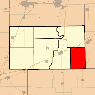
Crooked Creek Township is one of eight townships in Cumberland County, Illinois, USA. As of the 2010 census, its population was 422 and it contained 204 housing units.
The Battle of Noonday Creek was a series of combat events in the Atlanta Campaign of the American Civil War that took place between June 10 and July 3 of 1864.

Big Darby Creek is a scenic river located in northwestern central Ohio, and an important tributary to the Lower Scioto River. The river's major tributary is the Little Darby Creek.

Crooked River is a waterway in Franklin County, Florida, that connects the tidal estuary of the Ochlockonee River to a junction with the tidal Carrabelle River and the New River above the town of Carrabelle, Florida. The Crooked River channel is 41 kilometres (25 mi) long, while its ends are 24 kilometres (15 mi) apart.
Cane Creek is a stream in Georgia, and is a tributary of the Chestatee River. The creek is approximately 14.72 miles (23.69 km) long.
The Roswell Historic District, in Roswell, Georgia in Fulton County, was listed on the National Register of Historic Places in 1974.
