Crystal Lake (Vilas County, Wisconsin)

Last updated
Crystal Lake
USA Wisconsin relief location map.svg
Red pog.svg
Crystal Lake
Usa edcp relief location map.png
Red pog.svg
Crystal Lake
Location Vilas County, Wisconsin
Coordinates 46°00′07″N89°36′47″W / 46.002°N 89.613°W / 46.002; -89.613
Type seepage lake
Average depth34 feet (10 m)
Max. depth67 feet (20 m)

Crystal Lake is one of at least 22 lakes of that name in the state of Wisconsin. [1] It has a surface area of about 93 acres, [2] and is located just south of Big Muskellunge Lake, in Vilas County in the Northern Highland region of Wisconsin. The nearest community is Sayner, about 5 miles to the east. Visitors have access to the lake from a public boat landing, public beaches and the Northern Highland-American Legion State Forest. Fish include panfish, largemouth bass, and trout.

Contents

Crystal Lake is a seepage lake, having neither tributary nor effluent. [3] The lake has a maximum depth of 67 feet and a mean depth of 34 feet. [4] The lake has very clear water, comparable to that of Lake Tahoe in California, or Crater Lake in Oregon. [5]

Background

Crystal Lake is a kettle hole lake, meaning it was formed from glacial movement and melting and it's located in Vilas County, Wisconsin. [6] Many kettle lakes are sealed by glacial till and have perched water tables, but Crystal Lake does not. [7] It is not surprising that Crystal lake is a seepage lake considering most lakes in Wisconsin are also seepage lakes. [8] Since this lake is a seepage lake, it doesn't receive water from an inlet or an outlet, 90% of its water is from precipitation, less than 5% of the water is from the groundwater supply, and it doesn't receive a lot of runoff water because of the pine trees surrounding the lake, the permeable soil surrounding the lake, and the lack of large differences in elevation. [9] [10] [7] [8] Most of the water in the lake coming from precipitation can contribute to less biodiversity in terms of fish [9] [8] [7] and means that most nutrients and minerals come from surface runoff, groundwater, and the atmosphere. [10] Biodiversity is also less common in oligotrophic lakes like Crystal lake. [9] [6] Crystal lake is also dimictic, [11] meaning that the water in the lake mixes twice a year and is stratified in between mixing periods.

Ecology

In 1994, Leptodiaptomus minutus , a copepod species, commonly carried the peritrich ciliate Epistylis lacustris; 70% of copepods in 1994 carried at least one ciliate. [9] This is a common phenomenon in many lakes and infested copepods often have lesions, making them easier prey which causes copepod populations to vary depending on ciliate infestation rates. [9] The experiment by Xie, Sanderson, Frost, and Magnuson found that in Crystal lake, infestation rates positively correlated with copepod population density. [9] This is contrary to another experiment performed on Shinhamako Lake which found a negative correlation between the two variables. The highest infestation rate in the study on Crystal Lake was 23.4% which is almost 7% less than the highest infestation rate in Shinhamako Lake at the time. [9]

Airborne pine pollen is very common in the area around Crystal Lake and the fluctuation of pine pollen at Crystal Lake in 1981 was found to be 6.5gm−2. [10] The sediment in Crystal Lake has an immense number of diatoms and pollen which may be caused in part by atmospheric pollen around the lake. [10] Evidence that pine pollen is extremely common in Crystal Lake can be found in the n-alkane deposits in the summer of 1981 because 66% of the n-alkane came from the pollen. [10] Pine pollen is also a main source of organic carbon, phosphorus, 45% of the phosphorus is from pollen, and K+, 20% of the positive potassium ion was from the pollen. [10] Although pine pollen contributes these elements, concentrations of phosphorus and silicone are low in Crystal Lake which is likely due to the low amounts of surface runoff the lake receives. [10]

In a study comparing three temperate lakes with three different trophic levels, Crystal Lake was the only lake with stable levels of automated ribosomal intergenic spacer analysis, ARISA, fragments in the years 2000 and 2001. [11] ARISA is a technique that allows researchers to gain knowledge about the community of bacteria present in the lake at the time. [11] The bacterial community did vary in the summer at the same time the lake was stratified. [11]

An experiment performed on Crystal Lake and four other lakes in Vilas County examined how El Niño and La Niña and climate oscillation affect chlorophyll α concentrations on the surface of the water and algae dynamics between the five lakes. [12] The chlorophyll α concentrations of the lakes changed in the same ways and amounts to different climate patterns and the results supported that climate oscillation and chlorophyll α concentrations are synchronized. [12] This study found that the chlorophyll α concentrations in seepage lakes, like Crystal Lake, tend to depend more on climate than other types of lakes, since their main water source is precipitation. [12] They also observed that algae growth is somewhat affected by climate, but there are of course other factors that contribute to it. [12]

Plant life

Despite being oligotrophic, there are nine different plant species in Crystal Lake. [6] [9] There are a few different microfossils in Crystal Lake, but a majority of them are land plants, with only one plant, a type of Isoete spore, that resides within the lake contributing to the microfossil collection. [6] The plants in the lake show rosette growth patterns. [6] [13] In many oligotrophic lakes, nutrients from the atmosphere may effect the phytoplankton in the lake and their productivity. [14] As mentioned in the Lake Ecology section, there are also a lot of pine trees surrounding the lake. [10]

Geology and soil content

Sandy beach on the East side of Crystal Lake. Crystal Lake East Beach JH.JPG
Sandy beach on the East side of Crystal Lake.

There are many small, soft water lakes in the area around Crystal Lake in Vilas County, Wisconsin and it is a possibility that these lakes used to be one big lake which was formed from a glacier. [7] Seepage lakes such as Crystal Lake have more dissolved minerals than the bog lakes, but has less hard water than drainage lakes in the area. [7] At 1.7 parts per million of calcium and magnesium in its water, Crystal Lake fits in with the other seepage lakes as far as dissolved mineral content. [7] The bedrock underlying the lakes in Vilas County does not hold much water because it is all crystalline, aside from water that may reside in between crystals. [7] Above the crystalline bedrock, there is drift made mainly of pink and gray granite, gabbro, pink rhyolite, gneiss, schist, and basalt with a little bit of quartzite, red sandstone, red slate, and red iron formation. [7] Crystal lake is entirely surrounded by outwash plains with two deep wells adjacent to it. [7] Directly beside Crystal Lake, there's yellow and gray sand along with small amounts of organic matter and this was found in the two wells drilled beside it to a depth of around 4 to 5 feet. [7]

Lead has been greatly increasing in concentration from the year 1850 to 2000 and 210 Pb dating using pelagic sediments showed that Crystal Lake has a mass sedimentation rate of 80 g m−2 a−1 with a variability rate of 45% from year to year. [15] This means that sediments from the pelagic zone in Crystal Lake were sampled, lead, or Pb, was taken from these samples and carbon dated to show its age which was used to determine how much sediment containing lead was deposited each year. 10,000 μg m−2 a−1 of Pb were recorded in atmospheric fluxes and PAHs had atmospheric fluxes of 34 μg m−2 a−1. [15] PAHs were also increasing from the year 1850 to 2000, but less than Pb while organic carbon and n-alkane concentrations have decreased and the amount of n-alkane from groundwater is considered negligible. [10] [15] The majority of 210 Pb in Crystal Lake is from the atmosphere and the majority of 210 Po, or polonium, in the lake is produced from the radioactive decay of the 210 Pb, or lead. [16]

Related Research Articles

<span class="mw-page-title-main">Nitrogen cycle</span> Biogeochemical cycle by which nitrogen is converted into various chemical forms

The nitrogen cycle is the biogeochemical cycle by which nitrogen is converted into multiple chemical forms as it circulates among atmospheric, terrestrial, and marine ecosystems. The conversion of nitrogen can be carried out through both biological and physical processes. Important processes in the nitrogen cycle include fixation, ammonification, nitrification, and denitrification. The majority of Earth's atmosphere (78%) is atmospheric nitrogen, making it the largest source of nitrogen. However, atmospheric nitrogen has limited availability for biological use, leading to a scarcity of usable nitrogen in many types of ecosystems.

<span class="mw-page-title-main">Benthos</span> Community of organisms that live in the benthic zone

Benthos, also known as benthon, is the community of organisms that live on, in, or near the bottom of a sea, river, lake, or stream, also known as the benthic zone. This community lives in or near marine or freshwater sedimentary environments, from tidal pools along the foreshore, out to the continental shelf, and then down to the abyssal depths.

<span class="mw-page-title-main">Tar pit</span> Asphalt pit or asphalt lake

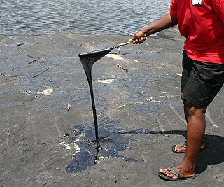
Tar pits, sometimes referred to as asphalt pits, are large asphalt deposits. They form in the presence of oil, which is created when decayed organic matter is subjected to pressure underground. If this crude oil seeps upward via fractures, conduits, or porous sedimentary rock layers, it may pool up at the surface. The lighter components of the crude oil evaporate into the atmosphere, leaving behind a black, sticky asphalt. Tar pits are often excavated because they contain large fossil collections.

<span class="mw-page-title-main">Proxy (climate)</span> Preserved physical characteristics allowing reconstruction of past climatic conditions

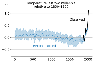
In the study of past climates ("paleoclimatology"), climate proxies are preserved physical characteristics of the past that stand in for direct meteorological measurements and enable scientists to reconstruct the climatic conditions over a longer fraction of the Earth's history. Reliable global records of climate only began in the 1880s, and proxies provide the only means for scientists to determine climatic patterns before record-keeping began.

<span class="mw-page-title-main">Non-methane volatile organic compound</span>

Non-methane volatile organic compounds (NMVOCs) are a set of organic compounds that are typically photochemically reactive in the atmosphere—marked by the exclusion of methane. NMVOCs include a large variety of chemically different compounds, such as benzene, ethanol, formaldehyde, cyclohexane, 1,1,1-trichloroethane and acetone. Essentially, NMVOCs are identical to volatile organic compounds (VOCs), but with methane excluded. Methane is excluded in air-pollution contexts because it is not toxic. It is however a very potent greenhouse gas, with low reactivity and thus a long lifetime in the atmosphere. An important subset of NMVOCs are the non-methane hydrocarbons (NMHCs).

High-nutrient, low-chlorophyll (HNLC) regions are regions of the ocean where the abundance of phytoplankton is low and fairly constant despite the availability of macronutrients. Phytoplankton rely on a suite of nutrients for cellular function. Macronutrients are generally available in higher quantities in surface ocean waters, and are the typical components of common garden fertilizers. Micronutrients are generally available in lower quantities and include trace metals. Macronutrients are typically available in millimolar concentrations, while micronutrients are generally available in micro- to nanomolar concentrations. In general, nitrogen tends to be a limiting ocean nutrient, but in HNLC regions it is never significantly depleted. Instead, these regions tend to be limited by low concentrations of metabolizable iron. Iron is a critical phytoplankton micronutrient necessary for enzyme catalysis and electron transport.

An oligotroph is an organism that can live in an environment that offers very low levels of nutrients. They may be contrasted with copiotrophs, which prefer nutritionally rich environments. Oligotrophs are characterized by slow growth, low rates of metabolism, and generally low population density. Oligotrophic environments are those that offer little to sustain life. These environments include deep oceanic sediments, caves, glacial and polar ice, deep subsurface soil, aquifers, ocean waters, and leached soils.

<span class="mw-page-title-main">Bristol Lake</span> Lake in United States of America

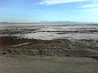
Bristol Lake is a dry lake in the Mojave Desert of San Bernardino County, California, 42 km (26 mi) northeast of Twentynine Palms.

<span class="mw-page-title-main">Paleolimnology</span> Scientific study of ancient lakes and streams

Paleolimnology is a scientific sub-discipline closely related to both limnology and paleoecology. Paleolimnological studies focus on reconstructing the past environments of inland waters using the geologic record, especially with regard to events such as climatic change, eutrophication, acidification, and internal ontogenic processes.

<span class="mw-page-title-main">Trophic state index</span> Measure of the ability of water to sustain biological productivity

The Trophic State Index (TSI) is a classification system designed to rate water bodies based on the amount of biological productivity they sustain. Although the term "trophic index" is commonly applied to lakes, any surface water body may be indexed.

The deep chlorophyll maximum (DCM), also called the subsurface chlorophyll maximum, is the region below the surface of water with the maximum concentration of chlorophyll. The DCM generally exists at the same depth as the nutricline, the region of the ocean where the greatest change in the nutrient concentration occurs with depth.

<span class="mw-page-title-main">Ecosystem of the North Pacific Subtropical Gyre</span> Major circulating ecosystem of ocean currents

The North Pacific Subtropical Gyre (NPSG) is the largest contiguous ecosystem on earth. In oceanography, a subtropical gyre is a ring-like system of ocean currents rotating clockwise in the Northern Hemisphere and counterclockwise in the Southern Hemisphere caused by the Coriolis Effect. They generally form in large open ocean areas that lie between land masses.

<span class="mw-page-title-main">Trout Lake (Wisconsin)</span> Lake in Wisconsin, USA

Trout Lake is in Vilas County, Wisconsin, near the towns of Boulder Junction and Arbor Vitae, Wisconsin. With a surface area of 6.208 sq mi (16.079 km2) and a volume of 0.058 cu mi (0.240 km3), Trout Lake is one of the largest lakes in Vilas County. It has 16.1 mi (25.9 km) of shoreline, a large portion of which is undeveloped. There are also seven islands within the lake: Miller Island, Zimmerman Island, Haunted Island, Easter Island, Fisk Island, Chocolate Drop Island, and an unnamed island. It is a dimictic oligotrophic lake that supports a large number of sport fish, which has made it a popular angling destination.

<span class="mw-page-title-main">Rice Creek State Natural Area</span> State Natural Area in Vilas County, Wisconsin, United States

Rice Creek is a Wisconsin Department of Natural Resources-designated State Natural Area that features a large, high-quality wetland complex of conifer swamps, fens, and sedge meadows along a two-mile stretch of Rice Creek. The creek contains dense, lush beds of emergent and submergent aquatic vegetation, including wild rice. White cedar, balsam fir, black spruce, and tamarack are the dominant trees in the conifer swamp. Several stands of old-growth hemlock/hardwood forest can be found in the site, each with a supercanopy of large white pine. Two fens, fed by groundwater seepages and of exceptional floristic diversity, are found near the creek. Overall, the site supports a high concentration of rare plants and animals. At least seven species of orchid are found here: showy lady slipper, heart-leaf twayblade, swamp pink, striped coralroot, blunt-leaf orchid, northern bog orchid, and boreal bog orchid. Other notable plant species include: bog arrowgrass, naked miterwort, marsh cinquefoil, purple clematis, and downy willowherb. Notable animal species present include: barred owl, Canada jay, pine siskin, winter wren, and bog copper.

<span class="mw-page-title-main">Paleo-climate of the Snake River Plain</span>

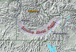
The paleo-climate of the Snake River Plain in southern Idaho, U.S., was much wetter and milder than today’s climate. During the Pliocene, the presence of a large lake provided habitat for fish. As the climate started to dry during the Pleistocene, vegetation similar to the present-day flora developed, although its geographical distribution was markedly different. Further drying occurred during the North American glaciation period that followed, resulting in the general aridity of the region today.

<span class="mw-page-title-main">Lake Estancia</span> Prehistoric lake in New Mexico, United States

Lake Estancia was a lake formed in the Estancia Valley, central New Mexico, which left various coastal landforms in the valley. The lake was mostly fed by creek and groundwater from the Manzano Mountains, and fluctuated between freshwater stages and saltier stages. The lake had a diverse fauna, including cutthroat trout; they may have reached it during a possible past stage where it was overflowing.

Pine Lake is a deep seepage lake near the community of Springwater, Wisconsin, in Waushara County, located in central Wisconsin. It is one of eight lakes that can be found in the township of Springwater. This lake is 137 acres with a 48-foot maximum depth. It is a popular attraction for both fisherman and boaters.

Low-nutrient, low-chlorophyll (LNLC)regions are aquatic zones that are low in nutrients and consequently have low rate of primary production, as indicated by low chlorophyll concentrations. These regions can be described as oligotrophic, and about 75% of the world's oceans encompass LNLC regions. A majority of LNLC regions are associated with subtropical gyres but are also present in areas of the Mediterranean Sea, and some inland lakes. Physical processes limit nutrient availability in LNLC regions, which favors nutrient recycling in the photic zone and selects for smaller phytoplankton species. LNLC regions are generally not found near coasts, owing to the fact that coastal areas receive more nutrients from terrestrial sources and upwelling. In marine systems, seasonal and decadal variability of primary productivity in LNLC regions is driven in part by large-scale climatic regimes leading to important effects on the global carbon cycle and the oceanic carbon cycle.

<span class="mw-page-title-main">Alpine lake</span> High-altitude lake in a mountainous zone

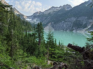
An alpine lake is a high-altitude lake in a mountainous area, usually near or above the tree line, with extended periods of ice cover. These lakes are commonly glacial lakes formed from glacial activity but can also be formed from geological processes such as volcanic activity or landslides. Many alpine lakes that are fed from glacial meltwater have the characteristic bright turquoise green color as a result of glacial flour, suspended minerals derived from a glacier scouring the bedrock. When active glaciers are not supplying water to the lake, such as a majority of Rocky Mountains alpine lakes in the United States, the lakes may still be bright blue due to the lack of algal growth resulting from cold temperatures, lack of nutrient run-off from surrounding land, and lack of sediment input. The coloration and mountain locations of alpine lakes attract lots of recreational activity.

<span class="mw-page-title-main">Water clarity</span> How deeply visible light penetrates through water

Water clarity is a descriptive term for how deeply visible light penetrates through water. In addition to light penetration, the term water clarity is also often used to describe underwater visibility. Water clarity is one way that humans measure water quality, along with oxygen concentration and the presence or absence of pollutants and algal blooms.

References

  1. Wisconsin Department of Natural Resources website, http://dnr.wi.gov/lakes/lakepages/Results.aspx?name=crystal%20lake. Retrieved 2014-08-30.
  2. Wisconsin Department of Natural Resources website, http://dnr.wi.gov/lakes/lakepages/LakeDetail.aspx?wbic=1842400. Retrieved 2014-08-30.
  3. James, Harry Raymond, with Edward A. Birge. A Laboratory Study of the Absorption of Light by Lake Waters. Wisconsin Academy of Sciences, Arts, and Letters, 1938. Table VIII, page 60.
  4. Wisconsin Department of Natural Resources website, http://dnr.wi.gov/lakes/lakepages/LakeDetail.aspx?wbic=1842400&page=facts. Retrieved 2014-08-30.
  5. Wetzel, Robert G. Limnology: Lake and River Ecosystems. 3rd ed. San Diego: Academic, 2001. Page 62.
  6. 1 2 3 4 5 Wilson, L. R.; Cross, A. T. (1943-05-01). "A study of the plant microfossil succession in the bottom deposits of Crystal Lake, Vilas County, Wisconsin, and the peat of an adjacent bog". American Journal of Science. 241 (5): 307–315. doi: 10.2475/ajs.241.5.307 . ISSN   0002-9599.
  7. 1 2 3 4 5 6 7 8 9 10 Fries, Carl. "Geology and groundwater of the Trout Lake region, Vilas County, Wisconsin" Limnological Laboratory of the Wisconsin Geological and Natural History Survey. 305-322.
  8. 1 2 3 "Lake Types". Wisconsin Lakes. 2016-08-29. Retrieved 2021-10-23.
  9. 1 2 3 4 5 6 7 8 Xie, Ping; Sanderson, Beth; Frost, Tom; Magnuson, John J. (2001). "Manipulation of Host Density Affects Infestation of a Peritrich Ciliate ( Epistylis lacustris ) on a Calanoid Copepod ( Leptodiaptomus minutus ) in Crystal Lake, Wisconsin, USA". Journal of Freshwater Ecology. 16 (4): 557–564. doi: 10.1080/02705060.2001.9663847 . ISSN   0270-5060.
  10. 1 2 3 4 5 6 7 8 9 Doskey, Paul V.; Ugoagwu, Barbara J. (1989-01-01). "Atmospheric deposition of macronutrients by pollen at a semi-remote site in northern Wisconsin". Atmospheric Environment. 23 (12): 2761–2766. doi:10.1016/0004-6981(89)90556-8. ISSN   0004-6981.
  11. 1 2 3 4 Yannarell, A. C.; Kent, A. D.; Lauster, G. H.; Kratz, T. K.; Triplett, E. W. (2003-12-01). "Temporal Patterns in Bacterial Communities in Three Temperate Lakes of Different Trophic Status". Microbial Ecology. 46 (4): 391–405. doi:10.1007/s00248-003-1008-9. ISSN   1432-184X. PMID   12904915. S2CID   23155197.
  12. 1 2 3 4 Xiao, Xi; He, Junyu; Yu, Yan; Cazelles, Bernard; Li, Ming; Jiang, Qutu; Xu, Caicai (2019-05-01). "Teleconnection between phytoplankton dynamics in north temperate lakes and global climatic oscillation by time-frequency analysis". Water Research. 154: 267–276. doi:10.1016/j.watres.2019.01.056. ISSN   0043-1354. PMID   30802701. S2CID   73472316.
  13. Wilson, L. R. (1935). "Lake Development and Plant Succession in Vilas County, Wisconsin". Ecological Monographs. 5 (2): 207–247. doi:10.2307/1948522. ISSN   0012-9615. JSTOR   1948522.
  14. Hamilton, D. P.; Spillman, C. M.; Prescott, K. L.; Kratz, T. K.; Magnuson, J. J. (2017-12-01). "Effects of atmospheric nutrient inputs and climate change on the trophic status of Crystal Lake, Wisconsin". Internationale Vereinigung für theoretische und angewandte Limnologie: Verhandlungen. 28: 467–470. doi:10.1080/03680770.2001.11902625. ISSN   0368-0770. S2CID   130543536.
  15. 1 2 3 Doskey, Paul V.; Talbot, Robert W. (2000). "Sediment chronologies of atmospheric deposition in a precipitation-dominated seepage lake". Limnology and Oceanography. 45 (4): 895–904. doi: 10.4319/lo.2000.45.4.0895 . ISSN   1939-5590.
  16. Talbot, Robert W; Andren, Anders W (1984-10-01). "Seasonal variations of 210Pb and 210Po concentrations in an oligotrophic lake". Geochimica et Cosmochimica Acta. 48 (10): 2053–2063. doi:10.1016/0016-7037(84)90386-7. ISSN   0016-7037.