
Mount Whitney is the tallest mountain in California, as well as the highest summit in the contiguous United States and the Sierra Nevada—with an elevation of 14,505 feet (4,421 m). It is in Central California, on the boundary between California's Inyo and Tulare counties, 84.6 miles (136.2 km) west-northwest of the lowest point in North America at Badwater Basin in Death Valley National Park at 282 ft (86 m) below sea level. The west slope of the mountain is in Sequoia National Park and the summit is the southern terminus of the John Muir Trail which runs 211.9 mi (341.0 km) from Happy Isles in Yosemite Valley. The east slope is in the Inyo National Forest in Inyo County.

Loma Prieta is 3,790 feet (1,160 m) high and is the highest peak in the Santa Cruz Mountains in Northern California. The peak is on private property about 11 miles (18 km) west of Morgan Hill in Santa Clara County. The dirt road to the summit is gated, but the tower maintainers generally do not mind hikers.

San Jacinto Peak is the highest peak of the San Jacinto Mountains, and of Riverside County, California. It lies within Mount San Jacinto State Park. Naturalist John Muir wrote of San Jacinto Peak, "The view from San Jacinto is the most sublime spectacle to be found anywhere on this earth!"

Mount Umunhum is the fourth-highest peak in California's Santa Cruz Mountains. The mountain is situated in Santa Clara County, south of San Jose. It is sometimes referred to as Mount Um by locals. Most of the mountain is within the Sierra Azul Open Space Preserve.

The Sangre de Cristo Mountains are the southernmost subrange of the Rocky Mountains. They are located in southern Colorado and northern New Mexico in the United States. The mountains run from Poncha Pass in South-Central Colorado, trending southeast and south, ending at Glorieta Pass, southeast of Santa Fe, New Mexico. The mountains contain a number of fourteen thousand foot peaks in the Colorado portion, as well as all the peaks in New Mexico which are over thirteen thousand feet.

The Sierra Madre Mountains are a mountain range primarily in northern Santa Barbara County and extending into northwestern Ventura County in Southern California, western United States. It is a range of the Inner South Coast Ranges group, and is the southernmost reach of the California Coast Ranges, which are themselves part of the Pacific Coast Ranges of western North America.

Mount Hamilton is a mountain in California's Diablo Range, in Santa Clara County, California. Mount Hamilton, at 4,265 feet (1,300 m) is a mountain overlooking Santa Clara Valley and is the site of Lick Observatory, the World's first permanently occupied mountain-topobservatory. The asteroid 452 Hamiltonia, discovered in 1899, is named after the mountain. Golden eagle nesting sites are found on the slopes of Mount Hamilton. On clear days, Mount Tamalpais, the Santa Cruz Mountains, Monterey Bay, the Monterey Peninsula, and even Yosemite National Park are visible from the summit of the mountain.
Black Mountain, also known as Mount Day, is a mountain in the Diablo Range of eastern Santa Clara County, California, east of Poverty Ridge and Arroyo Hondo, and about 10 miles (16 km) from Milpitas.

Uncompahgre Peak is the sixth highest summit of the Rocky Mountains of North America and the U.S. state of Colorado. The prominent 14,321-foot (4365.0 m) fourteener is the highest summit of the San Juan Mountains and the highest point in the drainage basin of the Colorado River and the Gulf of California. It is located in the Uncompahgre Wilderness in the northern San Juans, in northern Hinsdale County approximately 7 miles (11 km) west of the town of Lake City.
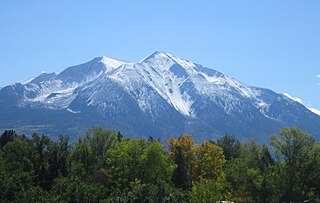
Mount Sopris is a twin-summit mountain in the northwestern Elk Mountains range of the Rocky Mountains of North America. The 12,965-foot (3,952 m) mountain is located in the Maroon Bells-Snowmass Wilderness of White River National Forest, 6.6 miles (10.7 km) north by northeast of the community of Redstone in Pitkin County, Colorado, United States.

Crystal Peak is a high mountain summit in the Tenmile Range of the Rocky Mountains of North America. The 13,859-foot (4,224 m) thirteener is located in White River National Forest, 5.9 miles (9.5 km) southwest of the Town of Breckenridge in Summit County, Colorado, United States.

Cuyamaca Peak is a mountain peak of the Cuyamaca Mountains range, in San Diego County, Southern California.

Santiago Peak is the southern mountain of Orange County's Saddleback formation. It is the highest and most prominent peak of both the Santa Ana Mountains and Orange County, and also marks a border point with Riverside County. The top of it is covered with many microwave and telecommunication antennas. It is named for Santiago Creek, which begins on its southwestern flank.
Double Peak is located south of San Marcos, California. The elevation at the summit is 1,646 ft (502 m), and approximately 1,000 feet above the north foot of the mountain. Most trails leading to the summit of Double Peak are classified as "moderately strenuous."

Mount Stakes is a mountain in the Diablo Range in California. The peak is located on the Santa Clara–Stanislaus county line; rises to an elevation of 3,810 feet (1,161 m) and is the highest point in Stanislaus County. It is 22 miles (35 km) west of Newman and 32 miles (51 km) southeast of Livermore. Some snow falls on the peak during the winter.

The Summit Fire was a wildfire that started on May 22, 2008 in the Santa Cruz Mountains, near Corralitos, California, United States. The fire was fully contained on May 27, 2008. No injuries or fatalities occurred, with the exception of twelve firefighters who received minor sprains, cuts and strains.

Toro Peak, in Southern California, is the highest mountain in the Santa Rosa Mountain Range. It is located 15 mi (24 km) south of Palm Springs, 12 mi (19 km) west of the Salton Sea, and 31 mi (50 km) east of Temecula, California.
Twin Peaks are two prominent peaks along the foothills east of the Santa Cruz Mountains in Santa Clara County, California. The peaks are nestled between Uvas Reservoir to the west, and Paradise Valley in Morgan Hill to the east. The headwaters for Sycamore Creek rise from the eastern hillsides near these peaks.
Mount Chual is a prominent peak in the Santa Cruz Mountains in southwest Santa Clara County, California, United States. The landmark lies 10 mi (16 km) west of Morgan Hill, and approximately 0.8 mi (1 km) northeast of Loma Prieta. It is the third highest peak in the Santa Cruz Mountains. Several tributaries to Llagas Creek originate on the southern and eastern flanks of the peak.

Mount Madonna is a prominent peak located near the southern end of the Santa Cruz Mountains in southwest Santa Clara County, California. The iconic landmark is surrounded by a county park, and is viewable along U.S. Route 101 in South Santa Clara Valley, and California State Route 152 near Watsonville in south Santa Cruz County.


