This page is based on this
Wikipedia article Text is available under the
CC BY-SA 4.0 license; additional terms may apply.
Images, videos and audio are available under their respective licenses.
U.S. Route 206 is a 130.23-mile-long (209.58 km) north–south United States highway in New Jersey and Pennsylvania, United States. Only about a half a mile of its length is in Pennsylvania; the Milford–Montague Toll Bridge carries it over the Delaware River into New Jersey, where it is the remainder of the route. The highway's northern terminus is near Milford, Pennsylvania at an intersection with US 209; some sources and signs show an overlap with US 209 to end at its parent route US 6. Its southern terminus is in Hammonton, New Jersey at an intersection with Route 54 and US 30. For much of its length, US 206 is a rural two-lane undivided road that passes through the Pine Barrens, agricultural areas, and the Appalachian Mountains of northwestern New Jersey, with some urban and suburban areas. The route connects several cities and towns, including Bordentown, Trenton, Princeton, Somerville, Netcong, and Newton. The road is known as the Disabled American Veterans Highway for much of its length.
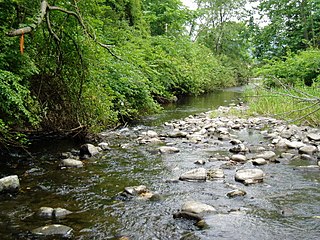
The South Branch Raritan River is a 50-mile-long (80 km) tributary of the Raritan River in central New Jersey in the United States.

Papakating Creek is a 20.1-mile-long (32.3 km) tributary of the Wallkill River located in Frankford and Wantage townships in Sussex County, New Jersey in the United States. The creek rises in a small swamp located beneath the eastern face of Kittatinny Mountain in Frankford and its waters join the Wallkill to the east of Sussex borough.
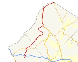
County Route 521, abbreviated CR 521, is a county highway in the U.S. state of New Jersey. The highway extends 43.71 miles from High Street in Hope Township to the New York state line in Montague Township.
The Warren Hills AVA is an American Viticultural Area located in Warren County, New Jersey. The Warren Hills region includes several small valleys formed by tributaries of the Delaware River. The valleys drain from northeast to southwest, and most vineyards in the area are planted on southeast-facing hill slopes. The region is primarily planted with French hybrid grapes. It has a humid continental climate and is located in hardiness zones 6b and 6a.

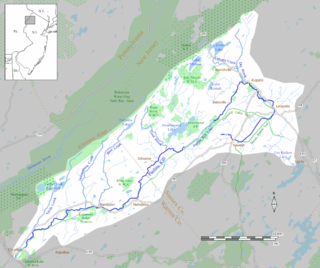
Lake Owassa is a 275 acres (111 ha) freshwater lake within the watershed of the Paulins Kill located in Frankford Township in Sussex County, New Jersey. It is fed from runoff from Kittatinny Mountain along its western flank and by Bear Swamp. Water from Lake Owassa feeds into nearby Culver's Lake before flowing into the West Branch of the Paulins Kill. It is at an elevation of 866 feet (264 m).
The Frankford Township School District is a comprehensive community public school district that serves students in pre-Kindergarten through eighth grade from Frankford Township, in Sussex County, New Jersey, United States. Students from Branchville attend the district's school as part of a sending/receiving relationship.
Culver's Lake is a lake located in Frankford Township, in Sussex County, New Jersey. Fed by Lake Owassa and Bear Swamp, Culver's Lake is the source of the West Branch of the Paulins Kill. In the late 19th and early 20th century, the lake was used for seasonal recreation. Today, it is a private year-round community owned and operated by the Normanoch Association, a homeowners' association.
Dry Brook is a tributary of the Paulins Kill in Frankford Township and Branchville Borough in Sussex County in northwestern New Jersey, United States. Its waters combine with the Culver Brook or West Branch of the Paulins Kill with the river's East Branch near the unincorporated hamlet Augusta near Branchville.
Jacksonburg Creek is a tributary of the Paulins Kill located along the eastern face of Kittatinny Mountain in Warren County in northwestern New Jersey in the United States. It rises near the Warren County-Sussex County border in Hardwick Township and enters the Paulins Kill approximately one mile south of Blairstown. The Appalachian Trail passes within its watershed and crosses the creek as it traverses the ridgeline of Kittatinny Mountain.

Neepaulakating Creek is a 2.4-mile long (3.8 km) tributary of Papakating Creek in Wantage Township in Sussex County, New Jersey in the United States. It is one of three streams feeding the Papakating Creek, a major contributor to the Wallkill River. Although the stream was dammed in the 1950s to create Lake Neepaulin as the focal point of a private residential development, the stream did not receive a name until 2002. Residents chose a name that combined elements of the names "Neepaulin" and "Papakating", and submitted a proposal to the United States Board of Geographic Names. The name was approved in 2004.

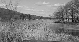
Swartswood Lake is a freshwater lake located in Stillwater and Hampton townships in Sussex County, New Jersey in the United States. The lake is a 520-acre (210 ha) glacial lake that is the third-largest freshwater lake in New Jersey. The lake stretches 3 miles (north-to-south) and 1 mile wide ; and has an average depth of 22 feet (6.7 m) with a maximum depth of 42 feet (13 m). The lake is the focus of Swartswood State Park a 3,460-acre (14.0 km2) protected area administered by the New Jersey Division of Parks and Forestry.
West Branch Papakating Creek is a tributary of Papakating Creek located in Frankford and Wantage townships in Sussex County, New Jersey, in the United States.