Route 55 is a state highway in the southern part of the U.S. state of New Jersey that is built to freeway standards. Also known as the Veterans Memorial Highway, it runs 40.54 miles (65.24 km) from an intersection with Route 47 in Port Elizabeth north to an interchange with Route 42 in Gloucester County. The Route 55 freeway serves as a main road through Cumberland and Gloucester counties, serving Millville, Vineland, and Glassboro. It is used as a commuter route north to Philadelphia and, along with Route 47, as a route from the Delaware Valley to the Jersey Shore resorts in Cape May County. Route 55 has a posted speed limit of 65 miles per hour (105 km/h) for most of its length.
Bridgeton is a city in Cumberland County, New Jersey, United States, in the southern part of the state, on the Cohansey River, near Delaware Bay. As of the 2010 United States Census, the city's population was 25,349, reflecting an increase of 2,578 (+11.3%) from the 22,771 counted in the 2000 Census, which had in turn increased by 3,829 (+20.2%) from the 18,942 counted in the 1990 Census. It is the county seat of Cumberland County. Bridgeton, Millville, and Vineland are the three principal cities of the Vineland-Millville-Bridgeton Primary Metropolitan Statistical Area, which encompasses those cities and all of Cumberland County for statistical purposes and which constitutes a part of the Delaware Valley.

Millville is a city in Cumberland County, New Jersey, United States. As of the 2010 United States Census, the city's population was 28,400, reflecting an increase of 1,553 (+5.8%) from the 26,847 counted in the 2000 Census, which had in turn increased by 855 (+3.3%) from the 25,992 counted in the 1990 Census. Millville, Bridgeton and Vineland are the three principal New Jersey cities of the Vineland-Millville-Bridgeton Primary Metropolitan Statistical Area which encompasses those cities and all of Cumberland County for statistical purposes.

Vineland is a city in Cumberland County, New Jersey, United States. As of the 2010 United States Census, the city had a total population of 60,724, reflecting an increase of 4,453 (+7.9%) from the 56,271 counted in the 2000 Census, which had in turn increased by 1,491 (+2.7%) from the 54,780 counted in the 1990 Census. The Census Bureau's Population Estimates Program calculated that the city's population was 59,439 in 2019, ranking the city the 636th-most-populous in the country. Vineland, Millville and Bridgeton are the three principal New Jersey cities of the Vineland–Millville–Bridgeton Primary Metropolitan Statistical Area, which encompasses those three cities and all of Cumberland County for statistical purposes and had a population of 156,898 as of the 2010 Census.
The Atlantic City Expressway is a 44.19-mile (71.12 km), controlled-access toll road in the U.S. state of New Jersey, managed and operated by the South Jersey Transportation Authority (SJTA). It serves as an extension of the freeway part of Route 42 from Turnersville southeast to Atlantic City. It connects Philadelphia and the surrounding Delaware Valley with Atlantic City and other Jersey Shore resorts, and also serves other South Jersey communities, including Hammonton and Mays Landing. The expressway intersects many major roads, including Route 73 in Winslow Township, Route 54 in Hammonton, Route 50 in Hamilton Township, the Garden State Parkway in Egg Harbor Township, and U.S. Route 9 (US 9) in Pleasantville.

Stockton University is a public university in Galloway Township, New Jersey. It is part of New Jersey's public system of higher education. It is named for Richard Stockton, one of the New Jersey signers of the Declaration of Independence. Founded in 1969, Stockton accepted its charter class in 1971. At its opening in 1971, classes were held at the Mayflower Hotel in Atlantic City; the campus in Galloway Township began operating late in 1971. Nearly 10,000 students are enrolled at Stockton and it is accredited by the Middle States Commission on Higher Education.

The River Line is a diesel tram-train Interurban light rail system in southern New Jersey, United States, that connects the cities of Camden and Trenton, New Jersey's capital. It is so named because its route between the two cities is parallel to the Delaware River.

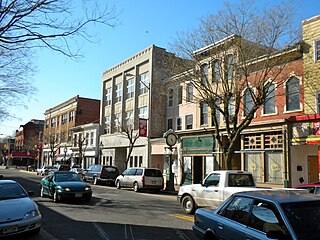
South Jersey comprises the southern portion of the U.S. state of New Jersey, between the lower Delaware River and the Atlantic Ocean. The designation of southern New Jersey with a distinct toponym is a colloquial one rather than an administrative one, reflecting not only geographical but also perceived cultural differences from the northern part of the state, with no official definition. Though definitions of South Jersey may vary, most of South Jersey is generally considered to be part of the Philadelphia Metropolitan Area.

Long Beach Island is a barrier island and summer colony along the Atlantic Ocean coast of Ocean County, New Jersey in the United States. Aligned north to south, the northern portion generally has more expensive low-density housing, whereas the southern portion possesses higher-density housing and considerable commercial development. Long Beach Island is less than one mile away from mainland New Jersey. The primary industries include tourism, fishing, and real estate. The only access point to the island by land is a single causeway.

Atlantic City International Airport is a shared civil-military airport 10 miles (16 km) northwest of Atlantic City, New Jersey, in Egg Harbor Township, the Pomona section of Galloway Township and in Hamilton Township. The airport is accessible via Exit 9 on the Atlantic City Expressway. The facility is operated by the South Jersey Transportation Authority (SJTA) and the Port Authority of New York and New Jersey, which performs select management functions. Most of the land is owned by the Federal Aviation Administration and leased to the SJTA, while the SJTA owns the terminal building.

New Jersey Pinelands National Reserve is a national reserve that encompasses the New Jersey Pine Barrens.

Alewife Brook Reservation is a Massachusetts state park and urban wild located in Cambridge, Arlington, and Somerville. The park is managed by the state Department of Conservation and Recreation and was established in 1900. It is named for Alewife Brook, which was also historically known as Menotomy River, a tributary of the Mystic River.

Dickens Heath is a large modern village and civil parish within the Metropolitan Borough of Solihull in the English county of West Midlands incorporating the much older hamlet of Whitlocks End. It was previously part of the civil parish of Hockley Heath, and borders Cheswick Green and Tidbury Green in Solihull, as well as Hollywood in Worcestershire.
Rowan College of South Jersey (RCSJ) is a public community college with two campuses New Jersey, one in Sewell and one in Vineland and Millville. The college was established in 1966 as Gloucester County College. In 2014 the college changed its name to Rowan College of Gloucester County when Rowan University and Gloucester County College entered into a partnership. The college then expanded in 2019, combining Rowan College at Gloucester County (RCGC) and Cumberland County College to become Rowan College of South Jersey. The college now offers conditional dual enrollment with Rowan University depending on GPA. While then GCC took the Rowan name, the community college maintains its independence with its own Board of Trustees and administration.

Trump Plaza was a hotel and casino on the Boardwalk in Atlantic City, New Jersey, owned by Trump Entertainment Resorts. Designed by architect Alan Lapidus, it operated from May 15, 1984 until September 16, 2014, and the vacant building was demolished on February 17, 2021.
Tanger Outlets The Walk is a 109-store open-air outlet mall in Atlantic City, New Jersey. It is the only outlet mall in Atlantic County. The mall opened in August 2003 and spans 3 city blocks, featuring a unique layout in outlet mall construction.

Harbor Square, formerly Shore Mall, is a shopping plaza in Egg Harbor Township, New Jersey in the United States on U.S. Route 40/U.S. Route 322 originally known as "Searstown". The plaza is accessible from Exit 36 off the Garden State Parkway. The plaza is owned by Aetna Realty. The plaza has a gross leasable area of 337,423 ft², formerly 620,000 ft² when it was a mall, located on 73 acres (300,000 m2) of land. The plaza's anchor store includes Boscov's.
Cumberland is a small unincorporated community located within Maurice River Township in Cumberland County, New Jersey, United States. For statistical purposes, Cumberland and neighboring Hesstown together comprise the Cumberland-Hesstown census-designated place.

Open spaces in urban environments, such as parks, playgrounds, and natural areas, can provide many health, cultural, recreational, and economic benefits to the communities nearby. However, access to open spaces can be unequal for people of different incomes. In California's two largest metropolitan regions, Los Angeles County in Southern California and the Bay Area in Northern California, access to green space and natural areas varies with the predominant races and classes of the communities. This also holds true in San Diego County in Southern California. Both expanding urbanization and diminishing funding for open space tend to widen these gaps in accessibility. Because open space is associated with various mental and physical benefits, a lack of access to it can pose health consequences. However, more research is needed to determine whether such environmental inequalities translate into long-term health inequalities, and, if so, how.