Tulare County is a county in the U.S. state of California. As of the 2010 census, the population was 442,179. Its county seat is Visalia. The county is named for Tulare Lake, once the largest freshwater lake west of the Great Lakes. Drained for agricultural development, the site is now in Kings County, which was created in 1893 from the western portion of the formerly larger Tulare County.

The Kings River is a 132.9-mile (213.9 km) river draining the Sierra Nevada mountain range in central California in the United States. Its headwaters originate along the Sierra Crest in and around Kings Canyon National Park and form the eponymous Kings Canyon, one of the deepest river gorges in North America. The river is impounded in Pine Flat Lake before flowing into the San Joaquin Valley southeast of Fresno. With its upper and middle course in Fresno County, the Kings River diverges into multiple branches in Kings County, with some water flowing south to the old Tulare Lake bed and the rest flowing north to the San Joaquin River. However, most of the water is consumed for irrigation well upstream of either point.
The St. John's River is a distributary of the Kaweah River in the San Joaquin Valley of California in the United States. The river begins at a diversion dam at McKay's Point, about a mile west of Lemon Cove. The distributary flows west along the north side of the city of Visalia, where it joins Elbow Creek, continuing west to Cross Creek.

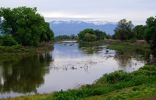
Lake Kaweah is a reservoir near Lemon Cove in Tulare County, California. The lake is formed by Terminus Dam on the Kaweah River. The river originates in the San Joaquin Valley beneath the Sierra Nevada mountains and drains about 560 sq mi (1,500 km2) into Lake Kaweah. From Lake Kaweah, the river flows toward the city of Visalia, splitting into the Kaweah River and St. Johns River as it flows west into the Tulare Lakebed. The lake has a capacity of 185,000 acre⋅ft (228,000,000 m3). A project to raise the lake 21 ft (6.4 m) was completed in 2004. The lake now impounds an additional 42,000 acre⋅ft (52,000,000 m3) and downstream flood protection to downstream communities and agricultural land has been increased.

The Kaweah River is a river draining the southern Sierra Nevada in Tulare County, California in the United States. Fed primarily by high elevation snowmelt along the Great Western Divide, the Kaweah begins as four forks in Sequoia National Park, where the watershed is noted for its alpine scenery and its dense concentrations of giant sequoias, the largest trees on Earth. It then flows in a southwest direction to Lake Kaweah – the only major reservoir on the river – and into the San Joaquin Valley, where it diverges into multiple channels across an alluvial plain around Visalia. With its Middle Fork headwaters starting at almost 13,000 feet (4,000 m) above sea level, the river has a vertical drop of nearly two and a half miles (4.0 km) on its short run to the San Joaquin Valley, making it one of the steepest river drainages in the United States. Although the main stem of the Kaweah is only 33.6 miles (54.1 km) long, its total length including headwaters and lower branches is nearly 100 miles (160 km).

Terminus Dam is a dam on the Kaweah River in Tulare County, California in the United States, located near Three Rivers about 15 mi (24 km) from the western boundary of Sequoia National Park and 20 mi (32 km) east of Visalia. The dam forms Lake Kaweah for flood control and irrigation water supply. Completed by the U.S. Army Corps of Engineers (USACE) in 1962, Terminus is an earthfill dam 255 ft (78 m) high and 2,375 ft (724 m) long. The reservoir has a maximum capacity of 185,600 acre⋅ft (0.2289 km3) of water, although it usually sits at much lower levels.

The South Fork Kern River is a tributary of the Kern River in the Sierra Nevada of the U.S. state of California. It is one of the southernmost rivers on the western slope of the mountains, and drains a high, relatively dry plateau country of 982 square miles (2,540 km2) along the Sierra Crest. The upper South Fork flows through a series of rugged canyons, but it also drains a flat, marshy valley before joining the Kern River at Lake Isabella.
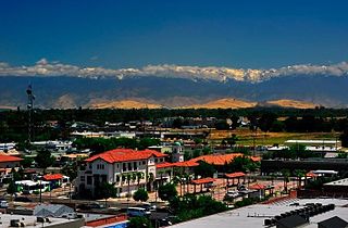
Visalia, California, commonly known in the 1850s as Four Creeks, is the oldest continuously inhabited inland European settlement between Stockton and Los Angeles. The city played an important role in the American colonization of the San Joaquin Valley as the county seat of Old Tulare County, an expansive region comprising most if not all of modern-day Fresno, Kings, and Kern counties.

Calgro is an unincorporated community in Tulare County, California, United States. Calgro is located on California State Route 63 and California State Route 201 11 miles (18 km) north of Visalia. The name of the community comes from an acronym for the California Growers Wineries.

Rocky Hill is an unincorporated community in Tulare County, California. It lies at an elevation of 1549 feet.
Ben Maddox Way is one of the principal north-south arterial roads in Visalia, California, United States. It was named for Benjamin Miller Maddox, editor-publisher of the Visalia Daily Times.

Cameron Creek is one of the four main creeks that flow through the city of Visalia and the surrounding communities.
Packwood Creek is one of the four main creeks that flow through the city of Visalia and the surrounding communities. It is a distributary of the Kaweah River.

The Visalia Branch Library system serves the residents of Visalia, California, United States.
Cairns Corner is an unincorporated community in Tulare County, California, United States. The community is located near the junction of California State Route 65 and California State Route 137 2.5 miles (4.0 km) west of Lindsay.
Silver City is a census-designated place (CDP) in the mountainous area of central Tulare County, California. Silver City sits at an elevation of 6,732 feet (2,052 m). It lies 72 km ENE of Visalia, California, within the boundary of Sequoia National Park. The 2010 United States census reported Silver City was uninhabited.
Sugarloaf Mountain Park is a census-designated place (CDP) in Tulare County, California. Sugarloaf Mountain Park sits at an elevation of 5,991 feet (1,826 m). The 2010 United States census reported Sugarloaf Mountain Park was uninhabited.

Wilsonia is a census-designated place (CDP) in Tulare County, California. Wilsonia sits at an elevation of 6,617 feet (2,017 m). It is surrounded by the General Grant Grove section of Kings Canyon National Park.