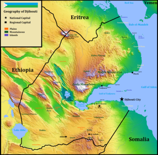
Djibouti is a country in the Horn of Africa. It is bordered by Eritrea in the north, Ethiopia in the west and south, and Somalia in the southeast. To the east is its coastline on the Red Sea and the Gulf of Aden. Rainfall is sparse, and most of the territory has a semi-arid to arid environment. Lake Assal is a saline lake which lies 155 m (509 ft) below sea level, making it the lowest point on land in Africa and the third-lowest point on Earth after the Sea of Galilee and the Dead Sea. Djibouti's major settlements include the capital Djibouti City, the port towns of Tadjoura and Obock, and the southern cities of Ali Sabieh and Dikhil. It is the 147st largest country in the world by land area, covering a total of 23,200 km2, of which 23,180 km2 is land and 20 km2 is water.

Eritrea is located in the Horn of Africa and is bordered on the northeast and east by the Red Sea, on the west and northwest by Sudan, on the south by Ethiopia, and on the southeast by Djibouti. The country has a high central plateau that varies from 1,800 to 3,000 meters (5,906–9,843 ft) above sea level. A coastal plain, western lowlands, and some 350 islands comprise the remainder of Eritrea's land mass. Eritrea has no year-round rivers.

Massawa is a city on the Red Sea coast of Eritrea located at the northern end of the Gulf of Zula beside the Dahlak Archipelago. As a historical and important port for many centuries, it was ruled by a succession of polities, including the Axumite Empire, Medri Bahri Kingdom, the Umayyad Caliphate, various Beja sultanates, the Ottoman Empire, the Khedivate of Egypt, Italy, Britain, and Ethiopia, until Eritrea's independence in 1991. Massawa was the capital of the Italian Colony of Eritrea until it was moved to Asmara in 1897.

The regions of Eritrea are the primary geographical divisions through which Eritrea is administered. Six in total, they include the Maekel/Central, Anseba, Gash-Barka, Debub/Southern, Northern Red Sea and Southern Red Sea regions.

The Mareb River, is a river flowing out of central Eritrea. Its chief importance is defining part of the boundary between Eritrea and Ethiopia, between the point where the Mai Ambassa enters the river at 14°53.6′N37°54.8′E to the confluence of the Balasa with the Mareb at 14°38′N39°1.3′E.

Debub Region, also known as the Southern Region, is a region of Eritrea. It lies along a portion of the national border with Ethiopia. As of 2005, the region had a population of 952,100 compared to a population of 839,700 in 2001. The net growth rate was 11.81 per cent. The total area of the province was 8000.00 km2 and the density was 119.01 persons per km2. The highest point in Eritrea, is Mount Soira 3,018 m (9,902 ft), is located in the region, situated east of Senafe. It shares borders with Central Region in the north, Zoba Northern Red Sea in the east, Gash Barka in the west and Ethiopia in the south. It is the largest region in the country by population.
Nakfa is a town in the Northern Red Sea region of Eritrea. It is also the name of a sub region of Eritrea.
Hamasien was a historical province including and surrounding Asmara, part of modern Eritrea. In 1996 the province was divided and distributed amongst the modern Maekel, Debub, Northern Red Sea, Gash-Barka, and Anseba regions.
The Tigre people are an ethnic group inhabiting Eritrea and Sudan. They are closely related to the Tigrayans and Beja. The Tigre speak the Tigre language, which belongs to the Semitic branch of the Afroasiatic family.
The Eritrean Premier League is the highest division in football in Eritrea. The league was delivered in 1994 to the first time.

The Eritrean Highlands are a mountainous region in central Eritrea. Bordered to the south by the Mareb River, it is a northern continuation of the Ethiopian Highlands. The region has seen tremendous deforestation since the colonial period, which began in the late 19th century. The Highlands are at particular risk of deforestation and associated soil erosion. Furthermore, the region, lying south of the Sahel are at particular risk of desertification and frequent drought. The Highlands experience, as most tropical regions, two seasons; the rainy season (kremti) is from June-September while the dry season is from September to June. The average temperature for Asmara, which is 2,340 m (7,677 ft) above sea level is approximately 16°C, but other places range from about 10°C to 25°C.
The Popular Liberation Forces were a group of soldiers that separated from the Eritrean Liberation Front (ELF). Two groups left the ELF at the same time, although from different regions of Eritrea.
The following outline is provided as an overview of and topical guide to Eritrea:
Eritrea, officially the State of Eritrea is a country in the Horn of Africa, with its capital at Asmara. It is bordered by Sudan in the west, Ethiopia in the south, and Djibouti in the southeast. The northeastern and eastern parts of Eritrea have an extensive coastline along the Red Sea. The nation has a total area of approximately 117,600 km2 (45,406 sq mi), and includes the Dahlak Archipelago and several of the Hanish Islands. Its toponym Eritrea is based on the Greek name for the Red Sea, which was first adopted for Italian Eritrea in 1890.
Football in Eritrea is related to the sport most popular in this African country. After being under Ethiopian control, Eritrea gained its independence in 1991 and in 1998 the country became a member of FIFA.

Italian Eritrea was a colony of the Kingdom of Italy in the territory of present-day Eritrea. Although it was formally created in 1890, the first Italian settlements in the area were established in 1882 around Assab. The colony officially lasted until 1947.

Eritrea–India relations refers to the international relations that exist between Eritrea and India. Eritrea maintains an embassy in New Delhi. The High Commission of India in Khartoum, Sudan is concurrently accredited to Eritrea. India also maintains an honorary consulate in Asmara.
