
Yukon is the smallest and westernmost of Canada's three territories. It is the second-least populated province or territory in Canada, with a population of 44,412 as of March 2023. Whitehorse, the territorial capital, is the largest settlement in any of the three territories.
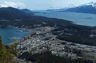
Haines is a census-designated place located in Haines Borough, Alaska, United States. It is in the northern part of the Alaska Panhandle, near Glacier Bay National Park and Preserve.

Tutchone is an Athabaskan language spoken by the Northern and Southern Tutchone First Nations in central and southern regions of Yukon Territory, Canada. Tutchone belongs to the Northern Athabaskan linguistic subfamily and has two primary varieties, Southern and Northern. Although they are sometimes considered separate languages, Northern and Southern Tutchone speakers are generally able to understand each other in conversation, albeit with moderate difficulty.
The Alaska Highway was constructed during World War II to connect the contiguous United States to Alaska across Canada. It begins at the junction with several Canadian highways in Dawson Creek, British Columbia, and runs to Delta Junction, Alaska, via Whitehorse, Yukon. When it was completed in 1942, it was about 2,700 kilometres (1,700 mi) long, but in 2012, it was only 2,232 km (1,387 mi). This is due to the continuing reconstruction of the highway, which has rerouted and straightened many sections. The highway opened to the public in 1948. Once legendary for being a rough, challenging drive, the highway is now paved over its entire length. Its component highways are British Columbia Highway 97, Yukon Highway 1, and Alaska Route 2.

Kluane National Park and Reserve are two protected areas in the southwest corner of the territory of Yukon. The National Park Reserve was set aside in 1972 to become a national park, pending settlement of First Nations land claims. It covered an area of 22,013 square kilometres. When agreement was reached with the Champagne and Aishihik First Nations over an eastern portion of the Reserve, that part—about 5,900 square kilometres —became a national park in 1993, and is a unit of the national park system administered co-operatively with Parks Canada. The larger western section remains a Reserve, awaiting a final land claim settlement with the Kluane First Nation. The park borders British Columbia to the south, while the Reserve borders both British Columbia to the south, and the United States (Alaska) to the south and west.
The Haines Highway or Haines Cut-Off is a highway that connects Haines, Alaska, in the United States, with Haines Junction, Yukon, Canada, passing through the province of British Columbia. It follows the route of the old Dalton Trail from the port of Haines inland for about 180 km (110 mi) to Klukshu, Yukon, and then continues to Haines Junction. The highway is about 244 km (152 mi) long, of which 72 km (45 mi) is in Alaska.

Haines Junction is a village in Yukon, Canada. It is at Kilometre 1,632 of the Alaska Highway at its junction with the Haines Highway, hence the name of the community. According to the 2021 Census, the population was 688. However, the Yukon Bureau of Statistics lists the population count for 2022 as 1,018.

Tatshenshini-Alsek Park or Tatshenshini-Alsek Provincial Wilderness Park is a provincial park in British Columbia, Canada 9,580 km2 (3,700 sq mi). It was established in 1993 after an intensive campaign by Canadian and American conservation organizations to halt mining exploration and development in the area, and protect the area for its strong natural heritage and biodiversity values.

The Aishihik River, also known as Canyon Creek, is a river in the Yukon Territory of Canada. Originating in Aishihik Lake, it flows south into the Dezadeash River, part of the Alsek River watershed.

Champagne Landing or Champagne Landing 10 is a First Nations settlement in Yukon, Canada. It is located on the Alaska Highway. Its residents are citizens of the Champagne and Aishihik First Nations.
Mule Creek Airport is located near to Mule Creek, British Columbia, Canada.
Matthew Carl Lien is a Canadian world music singer-songwriter and producer. His primary lyrical and musical focus is on environmental and cultural themes.

Stewart Crossing is a settlement in Yukon, Canada located on the Stewart River. It is about 179 km east of Dawson City on the Klondike Highway, near the junction with the Silver Trail, from which it is about 53 km (33 mi) southwest of Mayo. A Yukon government highway maintenance camp and a highway lodge are the most prominent facilities at Stewart Crossing. The settlement is named for where the Klondike Highway, crossed the Stewart River by means of a ferry from 1950 until completion of a bridge in the mid-1950s.
Pleasant Camp is a government facility in the remote Atlin District of northwestern British Columbia, Canada at an elevation of 274.3 metres (900 ft). It is the western-most community in British Columbia. The sole structures are the Port of Entry, staff housing, and maintenance buildings. This location offers no public amenities or services.
The Dezadeash Range is a mountain range in southern Yukon, Canada, located east of Haines Junction and south of the Alaska Highway. It has an area of 1,005 km2 (388 sq mi) and its appearance has a triangular shape. Although it can be considered to lie within the northern Boundary Ranges of the Coast Mountains, the Canadian Government consider the Dezadeash Range as part of the Yukon Plateau.
Glacier Camp is an uninhabited locality in far northwestern British Columbia, Canada, located on the route of the Haines Highway and the Dalton Trail. During the Klondike Gold Rush, it was a major boomtown-staging ground for travellers bound from Haines, Alaska to the Yukon and also was a mining camp itself. Abandoned today though a few ruins are extant, it is located west of Bennett, British Columbia near the confluence of Mule and Nadahini Creeks. Forming a pass between the basins of the Tatshenshini and Kelsall Rivers, it forms the prominence col for the Devils Paw, a summit in the Boundary Ranges.

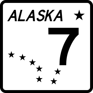
The Dalton Cache–Pleasant Camp Border Crossing connects the towns of Haines, Alaska and Haines Junction, Yukon on the Canada–United States border. Alaska Route 7 on the American side joins Yukon Highway 3 on the Canadian side as part of the Haines Highway.

Mount Worthington is a 2,168-metre (7,113-foot) mountain summit in the Auriol Range of the Saint Elias Mountains, in Kluane National Park of Yukon, Canada. The mountain is situated above the shores of Kathleen Lake, 7.2 km (4 mi) northwest of Kings Throne Peak across the lake, and 19 km (12 mi) south-southeast of Haines Junction, Yukon. The mountain can be seen from the Haines Highway as it prominently rises 1,570-metre (5,150-foot) above the lake. The mountain's name was officially adopted August 12, 1980, by the Geographical Names Board of Canada. Based on the Köppen climate classification, Mount Worthington is located in a subarctic climate with long, cold, snowy winters, and mild summers.

