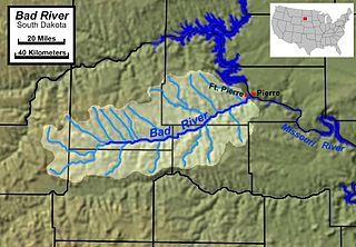
The Bad River is a tributary of the Missouri River, approximately 161 miles (259 km) long, in central South Dakota in the United States. The river is formed at Philip, South Dakota, by the confluence of its North and South forks. The North Fork Bad River rises in eastern Pennington County and flows 51 miles (82 km) east-southeast to Philip, while the South Fork Bad River rises at the confluence of Whitewater Creek and Big Buffalo Creek in Jackson County, within the Buffalo Gap National Grassland, and flows 36 miles (58 km) northeast to Philip. The main stem of the Bad River flows east-northeast from Philip, passing Midland and Capa. It joins the Missouri at Fort Pierre. The Bad drainage basin is about 3,000 square miles (7,800 km2) and is located south of the Cheyenne River in the Pierre Hills and Southern Plateaus.

The Niobrara River is a tributary of the Missouri River, approximately 568 miles (914 km) long, running through the U.S. states of Wyoming and Nebraska. The river drains one of the most arid sections of the Great Plains, and has a low flow for a river of its length. The Niobrara's watershed includes the northern tier of Nebraska Sandhills, a small south-central section of South Dakota, as well as a small area of eastern Wyoming.

The Keya Paha River is a river flowing 127 miles (204 km) through the U.S. states of South Dakota and Nebraska.

The Kentucky River is a tributary of the Ohio River, 260 miles (418 km) long, in the U.S. Commonwealth of Kentucky. The river and its tributaries drain much of the central region of the state, with its upper course passing through the coal-mining regions of the Cumberland Mountains, and its lower course passing through the Bluegrass region in the north central part of the state. Its watershed encompasses about 7,000 square miles (18,000 km2). It supplies drinking water to about one-sixth of the population of the Commonwealth of Kentucky.

The Feather River is the principal tributary of the Sacramento River, in the Sacramento Valley of Northern California. The river's main stem is about 73 miles (117 km) long. Its length to its most distant headwater tributary is just over 210 miles (340 km). The main stem Feather River begins in Lake Oroville, where its four long tributary forks join—the South Fork, Middle Fork, North Fork, and West Branch Feather Rivers. These and other tributaries drain part of the northern Sierra Nevada, and the extreme southern Cascades, as well as a small portion of the Sacramento Valley. The total drainage basin is about 6,200 square miles (16,000 km2), with approximately 3,604 square miles (9,330 km2) above Lake Oroville.

The Smith River flows from the Klamath Mountains to the Pacific Ocean in Del Norte County in extreme northwestern California, on the West Coast of the United States. The river, about 25.1 miles (40.4 km) long, all within Del Norte County, flows through the Rogue River – Siskiyou National Forest, Six Rivers National Forest, and Jedediah Smith Redwoods State Park.

The One Hundred and Two River is a tributary of the Platte River of Missouri in northwestern Missouri in the United States. It flows from source tributaries in southwestern Iowa about 80 miles (130 km) to the Platte. Via the Platte, it is part of the watershed of the Missouri River. Much of the river's course has been straightened and channelized.

The Snake River is a 126-mile-long (203 km) tributary of the Niobrara River. Entirely located within the Sandhills of north-central Nebraska, the Snake River rises near the eastern edge of Sheridan County. It flows eastward into Cherry County and passes along the southern edge of Samuel R. McKelvie National Forest. On the southeast edge of the national forest, the river is dammed to form Merritt Reservoir. At this point, the river makes a sharp turn to the north. At Burge, the river has a mean annual discharge of 158 cubic feet per second.

The Whetstone River is a 12.7-mile-long (20.4 km) tributary of the Minnesota River, in northeastern South Dakota and a very small portion of western Minnesota in the United States. Via the Minnesota River, it is part of the watershed of the Mississippi River.

The Cranberry River is a tributary of the Gauley River located in southeastern West Virginia in the United States. It is a part of the Mississippi River watershed, by way of the Gauley, Kanawha, and Ohio Rivers, draining an area of 74 square miles (192 km2).

The Nishnabotna River is a tributary of the Missouri River in southwestern Iowa, northwestern Missouri and southeastern Nebraska in the United States. It flows for most of its length as two parallel streams in Iowa, the East Nishnabotna River and the West Nishnabotna River. The east and west branches are each about 120 miles (190 km) long; from their confluence the Nishnabotna flows approximately another 16 miles (26 km).
The Fabius River is a 3.5-mile-long (5.6 km) tributary of the Mississippi River in northeastern Missouri in the United States. It is formed near its mouth by the confluence of the North Fabius River and the South Fabius River. The North Fabius River also flows through southeastern Iowa. The Middle Fabius River joins the North Fabius 8.9 miles (14.3 km) upstream of that river's mouth.

The Nolin River is a 104-mile-long (167 km) tributary of the Green River in central Kentucky in the United States. Via the Green and Ohio rivers, it is a part of the watershed of the Mississippi River.

Jacks Fork is one of two rivers in Missouri that are part of the Ozark National Scenic Riverways system.
Greer Spring is a first magnitude spring located in the southeast portion of the Ozark Plateau, in Oregon County in south-central Missouri within the boundaries of the Mark Twain National Forest. The spring is the second largest spring in the Ozarks, with an average discharge of 360 cubic feet (10 m3) of water per second. Greer Spring was designated a National Natural Landmark in 1980.

The South Fork Trinity River is the main tributary of the Trinity River, in the northern part of the U.S. state of California. It is part of the Klamath River drainage basin. It flows generally northwest from its source in the Klamath Mountains, 92 miles (148 km) through Humboldt and Trinity Counties, to join the Trinity near Salyer. The main tributaries are Hayfork Creek and the East Branch South Fork Trinity River. The river has no major dams or diversions, and is designated Wild and Scenic for its entire length.

Big Butte Creek is a 12-mile-long (19 km) tributary of the Rogue River in the U.S. state of Oregon. It drains approximately 245 square miles (635 km2) of Jackson County. Its two forks, the North Fork and the South Fork, both begin high in the Cascade Range near Mount McLoughlin. Flowing predominantly west, they meet near the city of Butte Falls. The main stem flows generally northwest until it empties into the Rogue Falls was incorporated in 1911, and remains the only incorporated town within the watershed's boundaries.

The North Fork Payette River is a river in the western United States in western Idaho. It flows about 113 miles (182 km) southwards from the Salmon River Mountains to near Banks, where it empties into the Payette River, a tributary of the Snake River. It drains a watershed of 912 square miles (2,360 km2), consisting of mountains and forests, and valleys filled with large lakes and wetlands.
Poso Creek or Posey Creek is an 87.9-mile (141.5 km) intermittent stream in Kern County, California.
Medicine Creek is a stream in Grundy, Livingston, Putnam, and Sullivan counties of the U.S. state of Missouri. It is a tributary to the Grand River.