Dobrina, Šentjur

Last updated
Dobrina
Slovenia location map.svg
Red pog.svg
Dobrina
Location in Slovenia
Coordinates: 46°9′1.39″N15°29′9.56″E / 46.1503861°N 15.4859889°E / 46.1503861; 15.4859889 Coordinates: 46°9′1.39″N15°29′9.56″E / 46.1503861°N 15.4859889°E / 46.1503861; 15.4859889
Country Flag of Slovenia.svg Slovenia
Traditional region Styria
Statistical region Savinja
Municipality Šentjur
Area
  Total 4.43 km2 (1.71 sq mi)
Elevation 525.2 m (1,723.1 ft)
Population (2002)
  Total 211
[1]

Dobrina (pronounced  [dɔˈbɾiːna] ) is a settlement in the Municipality of Šentjur in eastern Slovenia. The area is part of the historical region of Styria. The municipality is now included in the Savinja Statistical Region. [2] It includes the hamlets of Brode, Drenovc, Glažuta, Hrastje, Svetilka, and Žusem. [3]

Municipality of Šentjur Municipality in Slovenia

The Municipality of Šentjur, named Municipality of Šentjur pri Celju until 2002, is a municipality in eastern Slovenia. The town of Šentjur is the seat of the municipality. With an area of 223 km2 it is one of the larger municipalities in Slovenia. The area was part of the traditional region of Styria. The municipality is now included in the Savinja Statistical Region. Saint George appears on the municipal coat of arms.

Slovenia republic in Central Europe

Slovenia, officially the Republic of Slovenia, is a sovereign state located in southern Central Europe at a crossroads of important European cultural and trade routes. It is bordered by Italy to the west, Austria to the north, Hungary to the northeast, Croatia to the southeast, and the Adriatic Sea to the southwest. It covers 20,273 square kilometers (7,827 sq mi) and has a population of 2.07 million. One of the successor states of the former Yugoslavia, Slovenia is a parliamentary republic and a member of the United Nations, of the European Union, and of NATO. The capital and largest city is Ljubljana.

Savinja Statistical Region Statistical region in 33

The Savinja Statistical Region is a statistical region in Slovenia. The largest town in the region is Celje. It is named after the Savinja River. The region is very diverse in natural geography; it mainly comprises the wooded mountainous terrain attractive to tourists, the fertile Lower Savinja Valley with good conditions for growing hops, the Kozje Hills, and the Velenje Basin with lignite deposits, used for electricity production. In 2013 the region invested more than EUR 127 million in environmental protection. In 2013, the region accounted for 14% of enterprises created and 8% of enterprises shut down. The region has good natural conditions for agriculture. In 2013 this region had more than 11,000 farms, which is 15% of all farms in Slovenia, ranking the region right behind the Drava Statistical Region. In agricultural area utilised and livestock, the region was also in second place. The region is a well-known and popular tourist destination. In 2012, tourist arrivals and overnight stays in the region represented 11.1% of all tourist arrivals in Slovenia and 15.0% of all overnight stays. On average, tourists spent four nights there.

Contents

Name

Dobrina was first mentioned in written sources circa 1480 as Dobring, Dobryn, and Dobrin. The name is derived from the shortened personal name *Dobrъ and thus literally means 'Dobrъ's village'. The personal name *Dobrъ is based on the Slavic adjective *dobrъ 'good'. [4] :112

The hamlet of Žusem was first attested in 1202 as Sůzzenheim (and as Sůzzenhaim in 1208). The Slovene name is derived from Middle High German, which also yielded the 19th-century German name Süssenheim. The name is a compound of Middle High German süze 'sweet' + heim 'house, dwelling, home'. [4] :493

Middle High German is the term for the form of German spoken in the High Middle Ages. It is conventionally dated between 1050 and 1350, developing from Old High German and into Early New High German. High German is defined as those varieties of German which were affected by the Second Sound Shift; the Middle Low German and Middle Dutch languages spoken to the North and North West, which did not participate in this sound change, are not part of MHG.

History

Until the Second World War, the hamlet of Žusem was an independent settlement. Together with Žusem Castle (German : Süssenheim), it was a fief of Krško. It belonged to the Lords of Süssenheim from 1203 to 1478, with short periods of ownership by the Counts of Celje. After this it was the property of the imperial governors; Leopold Fieglmüller had the castle razed in 1876. [3]

German language West Germanic language

German is a West Germanic language that is mainly spoken in Central Europe. It is the most widely spoken and official or co-official language in Germany, Austria, Switzerland, South Tyrol (Italy), the German-speaking Community of Belgium, and Liechtenstein. It is also one of the three official languages of Luxembourg and a co-official language in the Opole Voivodeship in Poland. The languages which are most similar to German are the other members of the West Germanic language branch: Afrikaans, Dutch, English, the Frisian languages, Low German/Low Saxon, Luxembourgish, and Yiddish. There are also strong similarities in vocabulary with Danish, Norwegian and Swedish, although those belong to the North Germanic group. German is the second most widely spoken Germanic language, after English.

Churches

The local parish church, built on a hill south of Žusem Castle, a 12th-century castle abandoned in 1871, is known as Žusem Parish. It is dedicated to Saint Valentine and belongs to the Roman Catholic Diocese of Celje. It was built in the early 18th century on the site of a 16th-century predecessor. The belfry dates to 1894. Right next to it is a second church, dedicated to Saint James (Slovene : sveti Jakob). It is a mid-15th-century Gothic building with a 17th-century belfry. [5]

Parish church church which acts as the religious centre of a parish

A parish church in Christianity is the church which acts as the religious centre of a parish. In many parts of the world, especially in rural areas, the parish church may play a significant role in community activities, often allowing its premises to be used for non-religious community events. The church building reflects this status, and there is considerable variety in the size and style of parish churches. Many villages in Europe have churches that date back to the Middle Ages, but all periods of architecture are represented.

Castle Fortified residential structure of medieval Europe

A castle is a type of fortified structure built during the Middle Ages by predominantly the nobility or royalty and by military orders. Scholars debate the scope of the word castle, but usually consider it to be the private fortified residence of a lord or noble. This is distinct from a palace, which is not fortified; from a fortress, which was not always a residence for royalty or nobility; and from a fortified settlement, which was a public defence – though there are many similarities among these types of construction. Usage of the term has varied over time and has been applied to structures as diverse as hill forts and country houses. Over the approximately 900 years that castles were built, they took on a great many forms with many different features, although some, such as curtain walls and arrowslits, were commonplace.

Saint Valentine Roman saint

Saint Valentine, officially Saint Valentine of Rome, was a widely recognized 3rd-century Roman saint, commemorated in Christianity on February 14 and since the High Middle Ages is associated with a tradition of courtly love.

Related Research Articles

Prebold Settlement in Styria, Slovenia

Prebold is a settlement in central Slovenia. It is the seat of the Municipality of Prebold. It lies on the edge of the lower Savinja Valley at the northern edge of the Sava Hills west of Celje. The area was part of the traditional region of Styria. The municipality is now included in the Savinja Statistical Region.

Šentjur Town in Styria, Slovenia

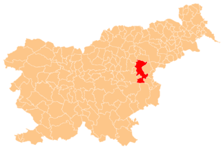
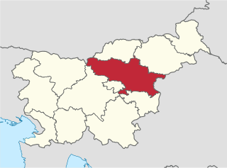
Šentjur is a town in eastern Slovenia. It is the seat of the Municipality of Šentjur. The town lies on the Voglajna River east of Celje. The area was part of the traditional region of Styria. The municipality is now included in the Savinja Statistical Region.

Brestanica Place in Styria, Slovenia

Brestanica is an urban settlement in the Municipality of Krško in eastern Slovenia. It lies in the valley at the confluence of the Sava River with a minor tributary called the Brestanica. The area was traditionally part of Styria. It is now included with the rest of the municipality in the Lower Sava Statistical Region.

Ivančna Gorica Settlement and Municipality in Lower Carniola, Slovenia

Ivančna Gorica is a settlement and a municipality in central Slovenia. It is part of the traditional region of Lower Carniola and is now included in the Central Slovenia Statistical Region.

Teharje Place in Styria, Slovenia

Teharje is a settlement in the City Municipality of Celje in eastern Slovenia. It lies on the right bank of the Voglajna River on the eastern outskirts of Celje. The area was traditionally part of the Styria region. It is now included with the rest of the municipality in the Savinja Statistical Region.

Setnica, Dobrova–Polhov Gradec Place in Upper Carniola, Slovenia

Setnica is a settlement that is divided between the municipalities of Dobrova–Polhov Gradec and Medvode in the Upper Carniola region of Slovenia. Setnica is known as Snica in the local dialect. In the 19th century it was known as Setnitza in German. The settlement includes the hamlets of Ravnek to the south, Mežnar below Saint Ursula's Church, and Kobilca in the Maček Gorge.

Pečine Place in Slovenian Littoral, Slovenia

Pečine is a village in the mountains above the right bank of the Idrijca River in the municipality of Tolmin in the Littoral region of Slovenia. It includes the hamlets of Črni Vrh, Kabiunk, Kal, Maraževec, Podkal, Travnik, and Stari Rut.

Bizeljsko Place in Styria, Slovenia

Bizeljsko is a settlement in the Municipality of Brežice in eastern Slovenia, close to the border with Croatia. It lies on the right bank of the Sotla River and in terms of its territory is the largest settlement in the Municipality of Brežice. The area was traditionally part of Styria. It is now included in the Lower Sava Statistical Region. It includes the hamlets of Bošt, Nimnik, Gradišče, Župjek, Spodnja Sušica, Zgornja Sušica, Janežičeva Gorca, Vrhovnica, and Vitna Vas.

Bukovje, Brežice in Styria, Slovenia

Bukovje is a settlement in the hills north of Bizeljsko in the Municipality of Brežice in eastern Slovenia. The area was traditionally part of Styria. It is now included with the rest of the municipality in the Lower Sava Statistical Region. It includes the hamlets of Graben to the west, which partially lies in the valley of Sračjak Creek, and Žalce, just above the Sotla River.

Čatež ob Savi Place in Lower Carniola, Slovenia

Čatež ob Savi is a village on the right bank of the Sava River at its confluence with the Krka River in the Municipality of Brežice in eastern Slovenia. The area was traditionally part of Lower Carniola. It is now included with the rest of the municipality in the Lower Sava Statistical Region.

Raka, Krško Place in Lower Carniola, Slovenia

Raka is a village in the Municipality of Krško in eastern Slovenia. The area was traditionally part of Lower Carniola. It is now included with the rest of the municipality in the Lower Sava Statistical Region. The village is known for a quality variety of onion.

Janče Place in Lower Carniola, Slovenia

Janče is a dispersed settlement in the hills south of the Sava River east of the capital Ljubljana in central Slovenia. It belongs to the City Municipality of Ljubljana. It was part of the traditional region of Lower Carniola and is now included with the rest of the municipality in the Central Slovenia Statistical Region.

Vodice pri Gabrovki in Lower Carniola, Slovenia

Vodice pri Gabrovki is a settlement north of Gabrovka in the Municipality of Litija in central Slovenia. Traditionally the area was part of Lower Carniola and is now included with the rest of the municipality in the Central Sava Statistical Region. The settlement includes the hamlets of Zgornje Vodice, Spodnje Vodice, and Greben.

Drtija Place in Upper Carniola, Slovenia

Drtija is a settlement in the Municipality of Moravče in central Slovenia. The area is part of the traditional region of Upper Carniola. It is now included with the rest of the municipality in the Central Slovenia Statistical Region. The settlement includes the hamlets of Belnik, Brinje, Gorica, Kovačija, Podbrdo, Kuga, Štance Laze, Štebalija, Štorovje, and Straža. Before the First World War, the hamlets scattered along the Slivna Plateau were collectively known as Za Goro.

Kolovrat, Zagorje ob Savi in Upper Carniola, Slovenia

Kolovrat is a settlement in the Municipality of Zagorje ob Savi in central Slovenia. The area is part of the traditional region of Upper Carniola. It is now included with the rest of the municipality in the Central Sava Statistical Region. The settlement includes the hamlets of Kal, Plavišnik, Prevalje, Spodnje Vrtače, Senčna Vas, and Strma Njiva.

Rodež in Lower Carniola, Slovenia

Rodež is a village in the Municipality of Zagorje ob Savi in central Slovenia. The area is part of the traditional region of Lower Carniola. It is now included with the rest of the municipality in the Central Sava Statistical Region. The village includes the hamlets of Klenovik and Boriče.

Liboje in Styria, Slovenia

Liboje is a settlement in the Municipality of Žalec in east-central Slovenia. It lies in the hills south of Žalec and southwest of Celje. The area is part of the traditional region of Styria. The municipality is now included in the Savinja Statistical Region. It includes the hamlets of Kurja Vas, Straža, and Svetli Dol or Tihi Gaj.

Močle in Styria, Slovenia

Močle is a village in the Municipality of Šmarje pri Jelšah in eastern Slovenia. It lies in the hills west of Šmarje. The area is part of the historical Styria region. The municipality is now included in the Savinja Statistical Region. It is a clustered village on the south side of a gentle slope. It includes the hamlets of Erpoge and Sveti Lovrenc.

Zlateče pri Šentjurju in Styria, Slovenia

Zlateče pri Šentjurju is a settlement in the Municipality of Šentjur in eastern Slovenia. The area is part of the historical region of Styria and is included in the Savinja Statistical Region.

Primož pri Šentjurju in Styria, Slovenia

Primož pri Šentjurju is a settlement in the Municipality of Šentjur in eastern Slovenia. The area is part of the historical Styria region. The municipality is now included in the Savinja Statistical Region. The settlement includes the hamlets of Bozne, Brezne, Grabne, and Kote.

References

  1. Statistical Office of the Republic of Slovenia
  2. Šentjur municipal site Archived 2011-01-15 at the Wayback Machine .
  3. 1 2 Savnik, Roman, ed. 1976. Krajevni leksikon Slovenije, vol. 3. Ljubljana: Državna založba Slovenije. pp. 324–325.
  4. 1 2 Snoj, Marko. 2009. Etimološki slovar slovenskih zemljepisnih imen. Ljubljana: Modrijan and Založba ZRC.
  5. Slovenian Ministry of Culture register of national heritage reference numbers ešd 3544 & 3545