Domanjševci

Last updated
Domanjševci
Domonkosfa

Pokopaliska cerkev sv. Martina v Domanjsevcih.jpg

Saint Martin's Church
Slovenia location map.svg
Red pog.svg
Domanjševci
Location in Slovenia
Coordinates: 46°47′2.5″N16°17′15.33″E / 46.784028°N 16.2875917°E / 46.784028; 16.2875917 Coordinates: 46°47′2.5″N16°17′15.33″E / 46.784028°N 16.2875917°E / 46.784028; 16.2875917
Country Flag of Slovenia.svg Slovenia
Traditional region Prekmurje
Statistical region Mura
Municipality Šalovci
Area
  Total 11.58 km2 (4.47 sq mi)
Elevation 252.1 m (827.1 ft)
Population (2002)
  Total 301
[1]

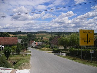
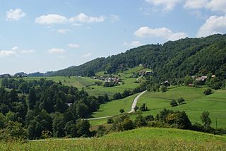
Domanjševci (pronounced  [dɔˈmaːnʃɛu̯tsi] ; in older sources also Domanjšovci, [2] Hungarian : Domonkosfa [2] ) is a village in the Municipality of Šalovci in the Prekmurje region of Slovenia, right on the border with Hungary. [3]

Hungarian language language spoken in and around Hungary

Hungarian is a Finno-Ugric language spoken in Hungary and several neighbouring countries. It is the official language of Hungary and one of the 24 official languages of the European Union. Outside Hungary it is also spoken by communities of Hungarians in the countries that today make up Slovakia, western Ukraine (Subcarpathia), central and western Romania (Transylvania), northern Serbia (Vojvodina), northern Croatia, and northern Slovenia. It is also spoken by Hungarian diaspora communities worldwide, especially in North America and Israel. Like Finnish and Estonian, Hungarian belongs to the Uralic language family. With 13 million speakers, it is its largest member in terms of speakers.

Village Small clustered human settlement smaller than a town

A village is a clustered human settlement or community, larger than a hamlet but smaller than a town, with a population ranging from a few hundred to a few thousand. Though villages are often located in rural areas, the term urban village is also applied to certain urban neighborhoods. Villages are normally permanent, with fixed dwellings; however, transient villages can occur. Further, the dwellings of a village are fairly close to one another, not scattered broadly over the landscape, as a dispersed settlement.

Municipality An administrative division having corporate status and usually some powers of self-government or jurisdiction

A municipality is usually a single administrative division having corporate status and powers of self-government or jurisdiction as granted by national and regional laws to which it is subordinate. It is to be distinguished (usually) from the county, which may encompass rural territory or numerous small communities such as towns, villages and hamlets.

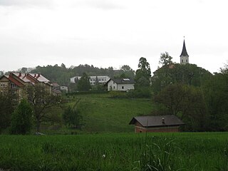
There are two churches in the settlement. The Roman Catholic church is built on a small hill southwest of the settlement in the middle of a small cemetery and is dedicated to Saint Martin. It is a single-nave brick building with a Romanesque portal dating to the 13th century. It was originally dedicated to Saint Wenceslas. The Lutheran church in the settlement was built in 1902 in a Neo-Romanesque style. Its designer was the architect Alojz Kleiber. [4]

Cemetery Place of burial

A cemetery or graveyard is a place where the remains of dead people are buried or otherwise interred. The word cemetery implies that the land is specifically designated as a burial ground and originally applied to the Roman catacombs. The term graveyard is often used interchangeably with cemetery, but a graveyard primarily refers to a burial ground within a churchyard.

Martin of Tours Christian saint

Saint Martin of Tours was the third bishop of Tours. He has become one of the most familiar and recognizable Christian saints in Western tradition.

Nave main body of a church

The nave is the central part of a church, stretching from the main entrance or rear wall, to the transepts, or in a church without transepts, to the chancel. When a church contains side aisles, as in a basilica-type building, the strict definition of the term "nave" is restricted to the central aisle. In a broader, more colloquial sense, the nave includes all areas available for the lay worshippers, including the side-aisles and transepts. Either way, the nave is distinct from the area reserved for the choir and clergy.

The poet, writer, and teacher István Szijjártó lived and died in the village.

István Szijjártó was a Slovene Lutheran teacher and poet in Hungary.

Related Research Articles

Lendava Town and Municipality in Slovenia

Lendava is a town and a municipality in Slovenia in the region of Prekmurje. The name of the settlement was changed from Dolnja Lendava to Lendava in 1955. It is close to the border crossing with Hungary at Dolga Vas-Rédics, and Hungarian is one of the official languages of the municipality, along with Slovene.

Cisnădie Town in Sibiu County, Romania

Cisnădie is a town in Sibiu County, Transylvania, Romania located approximately 10 kilometres (6.2 mi) south of Sibiu. One village, Cisnădioara, is administered by the town.

Moravče, Moravče Town in Slovenia

Moravče is a settlement in the Municipality of Moravče in central Slovenia. Traditionally the area was part of the Upper Carniola region. The village is home to about 925 people. It includes the hamlet of Trzen.

Gornji Petrovci Place in Prekmurje, Slovenia

Gornji Petrovci is a town in Slovenia. It is the seat of the Municipality of Gornji Petrovci.

Kobilje Town and Municipality in Slovenia

Kobilje is a village and a municipality in the Prekmurje region of Slovenia, on the border with Hungary. Kobilje Creek, a left tributary of the Ledava River, flows through it.

Hács Village in Southern Transdanubia, Hungary

Hács is a village in Somogy county, Hungary.

Pangrč Grm Place in Lower Carniola, Slovenia

Pangrč Grm is a settlement in the foothills of the Gorjanci range in the Municipality of Novo Mesto in southeastern Slovenia. The area is part of the traditional region of Lower Carniola and is now included in the Southeast Slovenia Statistical Region.

Črna pri Kamniku Place in Upper Carniola, Slovenia

Črna pri Kamniku is a village in the Municipality of Kamnik in the Upper Carniola region of Slovenia.

Bogojina Place in Prekmurje, Slovenia

Bogojina is a village east of Murska Sobota in the Prekmurje region of Slovenia. It lies in the Municipality of Moravske Toplice.

Kančevci Place in Prekmurje, Slovenia

Kančevci is a village in the Municipality of Moravske Toplice in the Prekmurje region of Slovenia.

Prosenjakovci Place in Prekmurje, Slovenia

Prosenjakovci is a village in the Municipality of Moravske Toplice in the Prekmurje region of Slovenia, close to the border with Hungary.

Selo, Moravske Toplice Place in Prekmurje, Slovenia

Selo is a village in the Municipality of Moravske Toplice in the Prekmurje region of Slovenia.

Pečarovci Place in Prekmurje, Slovenia

Pečarovci is a village in the Municipality of Puconci in the Prekmurje region of Slovenia.

Dolenci, Šalovci in Prekmurje, Slovenia

Dolenci is a village in the Municipality of Šalovci in the Prekmurje region of Slovenia, on the border with Hungary.

Markovci, Šalovci in Prekmurje, Slovenia

Markovci is a village in the Municipality of Šalovci in the Prekmurje region of Slovenia.

Gora, Krško in Lower Carniola, Slovenia

Gora is a small village in the hills northwest of Leskovec in the Municipality of Krško in eastern Slovenia. The area was traditionally part of Lower Carniola. It is now included with the rest of the municipality in the Lower Sava Statistical Region.

Tolsti Vrh, Šentjernej in Lower Carniola, Slovenia

Tolsti Vrh is a settlement in the foothills of the Žumberak/Gorjanci range in the Municipality of Šentjernej in southeastern Slovenia. It was traditionally part of Lower Carniola and is now included in the Southeast Slovenia Statistical Region.

Fara, Kostel Place in Lower Carniola, Slovenia

Fara is a settlement on the left bank of the Kolpa River in the Municipality of Kostel in southern Slovenia. The municipal administration is based in the settlement. The area is part of the traditional region of Lower Carniola and is now included in the Southeast Slovenia Statistical Region.

Drožanje Place in Styria, Slovenia

Drožanje is a settlement just north of Sevnica in east-central Slovenia. The area is part of the historical region of Styria. The Municipality of Sevnica is now included in the Lower Sava Statistical Region.

Municipality of Hodoš Municipality in Slovenia

The Municipality of Hodoš is a municipality in Slovenia. The seat of the municipality is the town of Hodoš. It is part of the Prekmurje region. Both Slovene and Hungarian are official languages in the municipality. The municipality comprises two villages: Hodoš and Krplivnik. The municipality was established on 7 August 1998, when it was separated from the former Municipality of Hodoš–Šalovci.

References