Donelson, Tennessee

Last updated

Donelson
Donelson Tennessee Post Office 2012.jpg
Donelson, Tennessee Post office
USA Tennessee location map.svg
Red pog.svg
Donelson
Location within Tennessee
Usa edcp location map.svg
Red pog.svg
Donelson
Location within the United States
Coordinates: 36°09′45″N86°40′12″W / 36.16250°N 86.67000°W / 36.16250; -86.67000
Country United States
State Tennessee
County Davidson
Time zone UTC-6 (Central (CST))
  Summer (DST) UTC-5 (CDT)
Zip codes
37076, 37214, 37229
Area code(s) 615, 629

Donelson is a neighborhood of Nashville, Tennessee, about 6 mi (10 km) east of downtown Nashville along U.S. Route 70. [1] It is named in honor of John Donelson, co-founder of Nashville and father-in-law of Andrew Jackson, Nashvillian and seventh President of the United States. Donelson is governed by the Metropolitan Council of Nashville and Davidson County, due to the fact that the government of Davidson County is consolidated with that of Nashville.

Contents

History

Donelson encompasses the site of historic Buchanan's Station where settlers in the early Nashville settlements held off a major incursion into the area by a united Native American force comprising Lower Cherokee and Creek Indians hoping to destroy Nashville and drive the American frontiersman back across the Appalachian Mountains. The vastly outnumbered defenders held out, eventually driving the attackers away. Today, the only extant remains of the compound is the Buchanan cemetery on the northwest corner of Elm Hill Pike and Massman Drive. [2] [3]

In the 1880s Donelson was a station on the Tennessee and Pacific Railroad just south of the former village of McWhirtersville on the Lebanon Pike. It began its modern development shortly after World War II, and its location next to Nashville's airport led to much of its later growth. It was also the site of an early example of what would later be called a shopping center or "strip mall", Donelson Plaza.

Donelson's oldest neighborhood is Bluefields. The development of the Bluefields subdivision began in 1929 by the Bransford Realty Company of Nashville, Tennessee. Home construction began in the early 1930s, with fifty to sixty homes built by the Bransford Realty Company by the end of 1938. The final phase of building, Bluefield Square, was developed in the 1970s on the property once occupied by the Swiss Farm Dairy within Bluefields proper.[ citation needed ] The Bluefields Historic District was added to the National Register of Historic Places listings in Davidson County, Tennessee on March 22, 2016. [4]

Donelson is now an example of an early postwar suburb with a stock of mostly half-century-old, red brick, detached ranch-style homes. However, there has been some tendency for infill in recent years, largely tied into the expansion of sewers. The area's desirability was increased somewhat by the impoundment of Percy Priest Lake on the Stones River in the late 1960s which increased summertime recreational opportunities.

Donelson was the home of the Opryland USA theme park, which closed in 1997. This property is now the Opry Mills shopping mall and the Grand Ole Opry. It is usually considered as something of a unit along with the adjacent neighborhood of Hermitage just across the Stones River along U.S. 70; the two communities share a Chamber of Commerce.

Donelson is home to hundreds of small and medium-sized local businesses. Hip Donelson, a tax exempt 501(c)3 created to promote and develop the local community, lists over 100 Donelson, Tennessee businesses that operate in the neighborhood. Donelson is also home to the national headquarters of HarperCollins Christian Publishers, a new branch of Nashville State University, and over 40 hotels and motels that cater to tourists and business travelers using BNA International Airport.

In recent years, Donelson has shown high demand as a desirable place to live, and is commonly discussed as one of the next Nashville neighborhoods set for explosive growth. A 2016 article on Realtor.com cited Donelson as the 15th most desirable zip code in the United States. [5] Donelson is one of about 26 suburban neighborhoods of Nashville. [6]

As with most communities which are not census-designated places, making a realistic estimate of the community's population is very problematic. Donelson is generally considered to be coextensive with the United States Postal Service's ZIP code 37214, which is the ZIP code for the Nashville Post Office's Donelson Station. According to the US Census Bureau 2016 estimates the population for the zip code 37214 was 30,230. [7]

The community has a station on the WeGo Star commuter rail line, which began operation in September 2006.

Geography

Donelson is located adjacent to Nashville International Airport. [8]

Climate

The mean annual temperature at Nashville International Airport is 60.8 °F (16.0 °C). Monthly averages range from 39.6 °F (4.2 °C) in January to 80.7 °F (27.1 °C) in July, with a diurnal temperature variation of 18.9 to 23.7 °F (10.5 to 13.2 °C). Diurnal temperature variation is highest in April and lowest in December, but it is also relatively high in October and relatively low in January. Donelson's climate classifications are Köppen Cfa and Trewartha CFak thanks to its very hot summers (average over 71.6 °F (22.0 °C)), mild winters (average over 32.0 °F (0.0 °C)) and long (8+ months) growing seasons (average over 50.0 °F (10.0 °C)). Precipitation is abundant year-round without any major difference, but there is still slight variation. The wet season runs from February through July, reaching its zenith in May with 128 mm of rain. The dry season runs from August through January with an October nadir of 85 mm and secondary December peak of 113 mm.

MonthJanFebMarAprMayJunJulAugSepOctNovDecYear
Record high °F (°C)78
(26)
85
(29)
89
(32)
91
(33)
96
(36)
109
(43)
107
(42)
106
(41)
105
(41)
99
(37)
88
(31)
79
(26)
109
(43)
Mean maximum °F (°C)68.5
(20.3)
73.3
(22.9)
80.1
(26.7)
85.3
(29.6)
89.9
(32.2)
94.7
(34.8)
97.1
(36.2)
96.7
(35.9)
93.4
(34.1)
86.4
(30.2)
78.1
(25.6)
69.6
(20.9)
98.5
(36.9)
Mean daily maximum °F (°C)49.1
(9.5)
53.8
(12.1)
62.7
(17.1)
72.6
(22.6)
80.4
(26.9)
87.7
(30.9)
90.9
(32.7)
90.4
(32.4)
84.4
(29.1)
73.5
(23.1)
61.4
(16.3)
52.2
(11.2)
71.6
(22.0)
Daily mean °F (°C)39.6
(4.2)
43.4
(6.3)
51.5
(10.8)
60.8
(16.0)
69.3
(20.7)
77.1
(25.1)
80.7
(27.1)
79.7
(26.5)
73.1
(22.8)
61.7
(16.5)
50.3
(10.2)
42.7
(5.9)
60.8
(16.0)
Mean daily minimum °F (°C)30.1
(−1.1)
33.0
(0.6)
40.2
(4.6)
48.9
(9.4)
58.3
(14.6)
66.4
(19.1)
70.5
(21.4)
69.0
(20.6)
61.8
(16.6)
49.9
(9.9)
39.2
(4.0)
33.3
(0.7)
50.1
(10.1)
Mean minimum °F (°C)11.2
(−11.6)
15.4
(−9.2)
22.7
(−5.2)
32.7
(0.4)
43.1
(6.2)
55.2
(12.9)
62.4
(16.9)
60.2
(15.7)
47.3
(8.5)
33.3
(0.7)
23.5
(−4.7)
17.4
(−8.1)
9.0
(−12.8)
Record low °F (°C)−17
(−27)
−13
(−25)
2
(−17)
23
(−5)
34
(1)
42
(6)
51
(11)
47
(8)
36
(2)
26
(−3)
−1
(−18)
−10
(−23)
−17
(−27)
Average precipitation inches (mm)4.02
(102)
4.47
(114)
4.52
(115)
4.72
(120)
5.02
(128)
4.36
(111)
4.16
(106)
3.79
(96)
3.80
(97)
3.36
(85)
3.86
(98)
4.43
(113)
50.51
(1,283)
Average snowfall inches (cm)2.0
(5.1)
1.5
(3.8)
0.7
(1.8)
0.0
(0.0)
0.0
(0.0)
0.0
(0.0)
0.0
(0.0)
0.0
(0.0)
0.0
(0.0)
0.0
(0.0)
0.1
(0.25)
0.4
(1.0)
4.7
(12)
Average extreme snow depth inches (cm)1
(2.5)
1
(2.5)
0
(0)
0
(0)
0
(0)
0
(0)
0
(0)
0
(0)
0
(0)
0
(0)
0
(0)
0
(0)
1
(2.5)
Average precipitation days (≥ 0.01 in)10.810.911.611.211.610.710.39.47.88.49.011.4123.1
Average snowy days (≥ 0.1 in)2.01.90.90.00.00.00.00.00.00.00.20.55.5
Average relative humidity (%)70.468.564.663.269.570.472.873.173.769.470.271.469.8
Average dew point °F (°C)26.4
(−3.1)
29.5
(−1.4)
36.9
(2.7)
45.1
(7.3)
55.9
(13.3)
63.9
(17.7)
68.0
(20.0)
66.9
(19.4)
61.2
(16.2)
48.4
(9.1)
39.4
(4.1)
31.3
(−0.4)
47.7
(8.7)
Mean monthly sunshine hours 139.6145.2191.3231.5261.8277.7279.0262.1226.4216.8148.1130.62,510.1
Percent possible sunshine 45485259606463636162484356
Average ultraviolet index 246791010975326
Source 1: NOAA (snow depth 1991-2023, relative humidity, dew point, and sun 1961−1990) [9] [10] [11]
Source 2: Weather Atlas (UV index) [12]

Notes

  1. Mean monthly maxima and minima (i.e. the expected highest and lowest temperature readings at any point during the year or given month) calculated based on data at said location from 1991 to 2020.
  2. Official records for Nashville were kept at downtown from December 1973 to December 1939, and at Nashville Int'l since January 1940. For more information, see Threadex

Related Research Articles

<span class="mw-page-title-main">Nashville, Tennessee</span> Capital city of Tennessee, United States

Nashville is the capital and most populous city in the U.S. state of Tennessee and the county seat of Davidson County. Located in Middle Tennessee, it had a population of 689,447 at the 2020 U.S. census. Nashville is the 21st most populous city in the United States, and the fourth most populous city in the southeastern U.S. Located on the Cumberland River, the city is the center of the Nashville metropolitan area, and is one of the fastest growing in the nation.

<span class="mw-page-title-main">Davidson County, Tennessee</span> County in Tennessee, United States

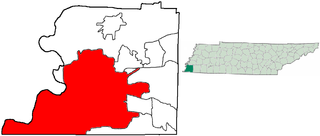
Davidson County is a county in the U.S. state of Tennessee. It is located in the heart of Middle Tennessee. As of the 2020 census, the population was 715,884, making it the 2nd most populous county in Tennessee. Its county seat is Nashville, the state capital and most populous city.

<span class="mw-page-title-main">Woodbury, Tennessee</span> Town in Tennessee, United States

Woodbury is a town in Cannon County, Tennessee, United States. Woodbury is part of the Nashville Metropolitan Statistical Area and is located 55 miles (89 km) southeast of downtown Nashville. The population of Woodbury was 2,680 at the 2010 census. It is the county seat of Cannon County.

<span class="mw-page-title-main">Belle Meade, Tennessee</span> City in Tennessee, United States

Belle Meade is a city in Davidson County, Tennessee. Its total land area is 3.1 square miles (8.0 km2), and its population was 2,901 at the time of the 2020 census.

<span class="mw-page-title-main">Bolivar, Tennessee</span> City in Tennessee, United States

Bolivar is a city in and the county seat of Hardeman County, Tennessee, United States. The town was named for South American revolutionary leader Simón Bolívar. As of the 2010 census, the city population was 5,417.

<span class="mw-page-title-main">Cookeville, Tennessee</span> Largest city and county seat of Putnam County, Tennessee, United States

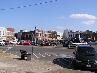
Cookeville is the county seat and largest city of Putnam County, Tennessee, United States. As of the 2020 United States census, its population was reported to be 34,842. It is recognized as one of the country's micropolitan areas, or smaller cities which function as significant regional economic hubs. Of the twenty micropolitan areas in Tennessee, Cookeville is the largest. The Cookeville micropolitan area's 2020 Census population was 141,333. The U.S. Census Bureau ranked the Cookeville micropolitan area as the 4th largest-gaining micropolitan area in the country between 2022 and 2023, with a one-year gain of 2,748 and a 2023 population of 148,226. The city is a college town, home to Tennessee Technological University.

<span class="mw-page-title-main">Springfield, Tennessee</span> City in Tennessee, United States

Springfield is the county seat of Robertson County, Tennessee, United States. It is located in Middle Tennessee near the northern border of the state. As of the 2020 census, the city's population was 18,782.

<span class="mw-page-title-main">Dover, Tennessee</span> City in Tennessee, United States

Dover is a city in and the county seat of Stewart County, Tennessee, 67 miles (108 km) west-northwest of Nashville on the Cumberland River. Fort Donelson National Cemetery is in Dover. The population was 1,442 at the 2000 census and the 2010 census showed a population of 1,417.

<span class="mw-page-title-main">Bristol, Tennessee</span> City in Tennessee, United States

Bristol is a city in Sullivan County, Tennessee, United States. The population was 27,147 at the 2020 census. It is the twin city of Bristol, Virginia, which lies directly across the state line between Tennessee and Virginia. The boundary between the two cities is also the state line, which runs along State Street in their common downtown district. It is a principal city in the Kingsport–Bristol metropolitan area, which had a population of 307,614 in 2020. The metro area is a component of the larger Tri-Cities region of Tennessee and Virginia, with a population of 508,260 in 2020.

<span class="mw-page-title-main">Franklin, Tennessee</span> City in Tennessee, United States

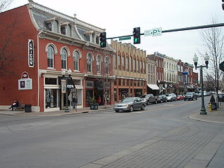
Franklin is a city in and county seat of Williamson County, Tennessee, United States. About 21 miles (34 km) south of Nashville, it is one of the principal cities of the Nashville metropolitan area and Middle Tennessee. As of 2020, its population was 83,454. It is the 7th most populous city in Tennessee. Franklin is known to be the home of many celebrities, mostly country music stars.

<span class="mw-page-title-main">Lebanon, Tennessee</span> City in Tennessee, United States

Lebanon is the county seat of Wilson County, Tennessee, United States. The population was 38,431 at the 2020 census. Lebanon is located in Middle Tennessee, approximately 25 miles (40 km) east of downtown Nashville. Lebanon is part of the Nashville Metropolitan Statistical Area.

<span class="mw-page-title-main">Bluefield, West Virginia</span> City in West Virginia, United States

Bluefield is a city in Mercer County, West Virginia, United States. The population was 9,658 at the 2020 census. It is the principal city of the Bluefield micropolitan area extending into Virginia, which had a population of 106,363 in 2020.

<span class="mw-page-title-main">Hermitage, Tennessee</span> Neighborhood in Davidson, Tennessee, United States

Hermitage, Tennessee, is located in eastern Davidson County, adjacent to – and named in honor of – The Hermitage, the historic home of Andrew Jackson, seventh President of the United States. Although the area is incorporated as part of the Metropolitan Government of Nashville and Davidson County, it maintains its own identity as a residential and commercial suburban area.

<span class="mw-page-title-main">Joelton, Tennessee</span> Community in Davidson and Cheatham counties, Tennessee, United States

Joelton is a neighborhood of Nashville in Davidson County in the U.S. state of Tennessee. Joelton is governed by the Metropolitan Council of Nashville and Davidson County, due to the fact that the government of Davidson County is consolidated with that of Nashville. Joelton's zip code also includes a portion in Cheatham County. In 2014, the population was 8,189.

<span class="mw-page-title-main">Vichy, Missouri</span> Unincorporated community in the American state of Missouri

Vichy is an unincorporated community in southern Maries County, Missouri, United States. It is located on U.S. Route 63, approximately ten miles north of Rolla. The community was founded in 1880 and is named after Vichy, France. A post office called Vichy has been in operation since 1880. The Rolla National Airport, a former U.S. Army airfield owned and operated by the City of Rolla, with two 5,500 ft (1,700 m) asphalt runways, is located nearby. The ZIP Code for Vichy is 65580.

<span class="mw-page-title-main">Old Hickory, Tennessee</span> Neighborhood of metropolitan Nashville, Tennessee

Old Hickory is a neighborhood of metropolitan Nashville, located in the Hadley Bend section of eastern Davidson County, Tennessee. Old Hickory is governed by the Metropolitan Council of Nashville and Davidson County, due to the fact that the government of Davidson County is consolidated with that of Nashville.

<span class="mw-page-title-main">Thermal, California</span> Resort community in Riverside County, southern California, United States

Thermal is an unincorporated community within the Coachella Valley in Riverside County, California, United States, located approximately 25 miles (40 km) southeast of Palm Springs and about 9.5 miles (15.3 km) north of the Salton Sea. The community's elevation is 138 feet (42 m) below mean sea level. It is served by area codes 760 and 442 and is in ZIP Code 92274. The population was 2,865 at the 2010 census. For statistical purposes, the United States Census Bureau has defined Thermal a census-designated place (CDP), which does not precisely correspond to the historical community.

<span class="mw-page-title-main">Nashville metropolitan area</span> Metropolitan area in Tennessee, United States

The Nashville metropolitan area is a metropolitan statistical area in north-central Tennessee. Its principal city is Nashville, the capital of and largest city in Tennessee. With a population of over 2 million, it is the most populous metropolitan area in Tennessee. It is also the largest metropolitan area in Tennessee in terms of land area.

<span class="mw-page-title-main">Geography of Memphis, Tennessee</span>

The City of Memphis is located on the eastern bank of the Mississippi River in the southwest corner of the U.S. state of Tennessee. It is the regional hub for a tri-state area of Arkansas, Mississippi and Tennessee.

<span class="mw-page-title-main">Geography of Kentucky</span> Overview of the Geography of Kentucky

Kentucky is situated in the Upland South region of the United States. A significant portion of eastern Kentucky is part of Appalachia.

References

  1. "Donelson". Geographic Names Information System . United States Geological Survey, United States Department of the Interior . Retrieved September 20, 2023.
  2. Allen, Dan S.; An Archaeological Survey of the Buchanan's Station Cemetery; Murfreesboro; Dan S. Allen and Associates; (2013)
  3. Buchanan’s Station and Cemetery; WebPage; Nashville Historical Newsletter online; retrieved December 2022
  4. "National Register Digital Assets - Bluefields Historic District". npgallery. National Park Service U.S. Department of the Interior. Retrieved December 10, 2022.
  5. Ward, Ghetan. "Donelson's ranked 15th hottest U.S. residential ZIP code". Tennessean. Retrieved December 23, 2016.
  6. Crawford, Stephanie. "Nashville Suburbs" . Retrieved October 7, 2021.
  7. Bureau, U.S. Census. "U.S. Census website". United States Census Bureau . Retrieved January 31, 2018.
  8. "Donelson · Nashville, TN".
  9. "NowData – NOAA Online Weather Data". National Oceanic and Atmospheric Administration. Retrieved May 17, 2021.
  10. "Station: NASHVILLE INTL AP, TN". U.S. Climate Normals 2020: U.S. Monthly Climate Normals (1991–2020). National Oceanic & Atmospheric Administration. Retrieved May 17, 2021.
  11. "WMO Climate Normals for NASHVILLE/METRO ARPT TN 19611990". National Oceanic and Atmospheric Administration. Retrieved March 10, 2014.
  12. "Nashville, Tennessee, USA - Monthly weather forecast and Climate data". Weather Atlas. Retrieved March 13, 2019.