
Capitol Hill is a neighborhood in Washington, D.C., located in both Northeast D.C. and Southeast D.C.. Bounded by 14th Street SE & NE, F Street NE, Southeast Boulevard SE, South Capitol Street SE. Dominated by the United States Capitol, which sits on the highest point of Capitol Hill, it is one of the oldest historic districts in Washington. Home to around 35,000 people in just under 2 square miles (5 km2), Capitol Hill is also one of the most densely populated neighborhoods. The name "Capitol Hill" is frequently used as a metonym for the U.S. Congress.

Anacostia is a historic neighborhood in Southeast Washington, D.C. Its downtown is located at the intersection of Marion Barry Avenue SE, Morris Road SE, Fort Stanton Park SE, and Anacostia Freeway SE. It is located east of the Anacostia River, after which the neighborhood is named.

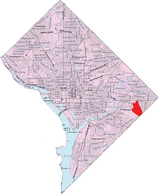
Stadium–Armory station is a Washington Metro station in Southeast, Washington, D.C. It is located at the border of the Barney Circle and Kingman Park neighborhoods. The station was opened on July 1, 1977, and is operated by the Washington Metropolitan Area Transit Authority (WMATA). Stadium–Armory serves the Blue, Orange and Silver Lines.

Congress Heights station is an island-platformed Washington Metro station situated in the Congress Heights neighborhood of Washington, D.C., United States. Opened on January 13, 2001, the station is operated by the Washington Metropolitan Area Transit Authority (WMATA). Serving only the Green Line, it is positioned at the intersection of Alabama Avenue and 13th Street, beneath St. Elizabeths Hospital. Congress Heights marks the terminus of the Green Line in the District of Columbia as it extends southeastward.

Southeast is the southeastern quadrant of Washington, D.C., the capital of the United States, and is located south of East Capitol Street and east of South Capitol Street. It includes the Capitol Hill and Anacostia neighborhoods, the Navy Yard, the Joint Base Anacostia-Bolling (JBAB), the U.S. Marine Barracks, the Anacostia River waterfront, Eastern Market, the remains of several Civil War-era forts, historic St. Elizabeths Hospital, RFK Stadium, Nationals Park, and the Congressional Cemetery. It also contains a landmark known as "The Big Chair," located on Martin Luther King Jr. Avenue. The quadrant is split by the Anacostia River, with the portion that is west of the river sometimes referred to as "Near Southeast". Geographically, it is the second-smallest quadrant of the city.
Northeast is the northeastern quadrant of Washington, D.C., the capital of the United States. It encompasses the area located north of East Capitol Street and east of North Capitol Street.

Barry Farm is a neighborhood in Southeast Washington, D.C., located east of the Anacostia River and bounded by the Southeast Freeway to the northwest, Suitland Parkway to the northeast and east, and St. Elizabeths Hospital to the south. The neighborhood was renowned as a significant post-Civil-War settlement of free Blacks and freed slaves established by the Freedmen's Bureau. The streets were named to commemorate the Union generals, Radical Republicans, and Freedmen's Bureau officials who advanced the rights of Black Americans during the Civil War and Reconstruction: Howard Road SE for General Oliver O. Howard; Sumner Road SE for Massachusetts Senator Charles Sumner; Wade Road SE for Ohio Senator Benjamin Wade; Pomeroy Road SE for Kansas Senator Samuel C. Pomeroy; Stevens Road SE for Pennsylvania Congressman Thaddeus Stevens, and Nichols Avenue for Henry Nichols who was the first superintendent of Saint Elizabeth's Hospital. The neighborhood name is not a reference to the late former mayor of Washington, D.C., Marion Barry, but coincidentally has the same spelling.
Benning Ridge is a residential neighborhood located in Southeast Washington, D.C. It is bounded by Fort Chaplin Park to the northwest, Southern Avenue to the south, Benning Road to the east, and Ridge Road SE to the west. Benning Ridge is an unusual neighborhood for its location east of the Anacostia River: although it is surrounded by working-class and low-income African American neighborhoods, Benning Ridge is rather affluent, with a diverse population of middle- and upper-middle-class white and black residents. As of 2015 the neighbourhood was one of the top ten most liberal neighbourhoods in Washington D.C..

Garfield Heights is a residential neighborhood in Southeast Bounded by Suitland Parkway SE, Alabama Avenue SE, 28th Street SE, Gainesville Street SE, Naylor Road SE, and Southern Avenue SE.Washington, D.C., bordering Prince George's County, Maryland. Garfield Heights contains both apartment units and single-family detached houses.
Shipley Terrace, formerly known as Randle Heights, is a large residential neighborhood in Southeast Washington, D.C., bordering Prince George's County, Maryland. The neighborhood, named after a former public housing complex in the neighborhood, which was largely occupied by low-income housing – primarily walkup and garden unit apartments. This neighborhood now has a mix of townhome communities, large single-family-home communities, as well as some low-income housing. It is a model neighborhood for the Hope VI revitalization Grant Program.

Washington Highlands is a residential neighborhood in Southeast Washington, D.C., in the United States. It lies within Ward 8. Bounded by Oxon Run Park(Oxon-Run Trail)SE, Livingston Road SE, South Capitol Street SE, Southern Avenue SE, Valley Avenue SE, and 13th Street SE.

Dupont Park is a residential neighborhood located in southeast Washington, D.C. It is bounded by Fort Dupont Park to the north, Pennsylvania Avenue SE to the south, Branch Avenue to the west, and Fort Davis Park to the east. The neighborhood civic association uses Fairlawn Avenue and the Anacostia Freeway as the western boundary of the neighborhood.

Northeast Boundary is small neighborhood located in the northeast quadrant of Washington, D.C., in the United States. Along with the Capitol View neighborhood, it is the easternmost neighborhood of the District of Columbia.

Navy Yard is a neighborhood of Washington, D.C., located in Southeast D.C. Navy Yard, situated along the Anacostia Riverfront south of Capitol Hill, takes its name from Washington Navy Yard, the administrative seat of the U.S. Navy. Historically an industrial area, today Navy Yard is a popular entertainment district, home to Nationals Park, a notable nightlife scene, and numerous waterfront esplanades.

Civic Betterment is a small neighborhood located in Southeast Washington, D.C., on the border of Prince George's County, Maryland. It is triangular in area, bounded by G and Fitch Streets SE to the north, Benning Road SE to the southwest, and Southern Avenue to the southeast.

Woodland is a small residential and industrial neighborhood in Southeast Washington, D.C. Woodland lies in Washington's Ward 8, among the poorest and least developed of the city's wards. Like the neighborhoods around it, Woodland is almost exclusively African American. Woodland is bounded by Ainger Place SE to the north; Alabama Avenue SE and Knox Place SE to the east; Hartford Street SE to the south; and Langston Place SE, Raynolds Place SE, and Erie Street SE to the southwest. Fort Stanton Park forms the northwest and northern border of the neighborhood.

Randle Highlands is a neighborhood in Southeast Washington, D.C., east of the Anacostia River.

Penn Branch is a neighborhood in Southeast Washington, D.C., east of the Anacostia River. It is bounded by Pennsylvania Avenue SE to the south; Pope Branch Park and Pope Creek to the north; Branch Avenue to the west; and Fort Davis Park to the east. ‘Penn Branch’, takes its name from its location at the intersection of two major thoroughfares, Pennsylvania and Branch Avenue.
Town Hall Education Arts Recreation Campus (THEARC) is a combined cultural and social services campus in Southeast Washington, D.C. The campus consists of three connected buildings, playgrounds, basketball courts and public spaces. In May 2007, THEARC won the Urban Land Institute's Award for Excellence and was cited for its contribution to the community, response to societal needs, innovation, public/private partnership and environmental protection and enhancement.
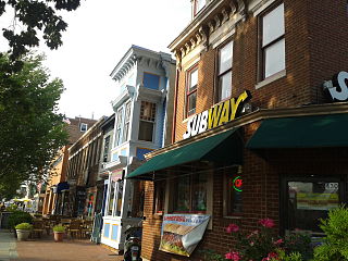
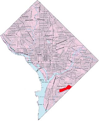
Barracks Row is a commercial strip along 8th Street SE that connects the Navy Yard and Capitol Hill neighborhoods in the Southeast of Washington, D.C., south of Eastern Market, between M Street SE and Pennsylvania Avenue SE. The area takes its name from the Marine Barracks, also known as 8th & I, which it faces along 8th Street SE.

