
The Upper Peninsulaof Michigan – also known as Upper Michigan or colloquially the U.P. – is the northern and more elevated of the two major landmasses that make up the U.S. state of Michigan; it is separated from the Lower Peninsula by the Straits of Mackinac. It is bounded primarily by Lake Superior to the north, separated from the Canadian province of Ontario at the east end by the St. Marys River, and flanked by Lake Huron and Lake Michigan along much of its south. Although the peninsula extends as a geographic feature into the state of Wisconsin, the state boundary follows the Montreal and Menominee rivers and a line connecting them.

Houghton is the largest city and county seat of Houghton County in the U.S. state of Michigan. Located on the Keweenaw Peninsula, Houghton is the largest city in the Copper Country region. It is the fifth largest city in the Upper Peninsula, with a population of 8,386 at the 2020 census. Houghton is the principal city of the Houghton micropolitan area, which includes all of Houghton and Keweenaw County.

Houghton County is a county in the Upper Peninsula in the U.S. state of Michigan. As of the 2020 Census, the population was 37,361. The county seat and largest city is Houghton. Both the county and the city were named for Michigan State geologist and Detroit Mayor Douglass Houghton.

Calumet is a village in Calumet Township, Houghton County, in the U.S. state of Michigan's Upper Peninsula, that was once at the center of the mining industry of the Upper Peninsula. Also known as Red Jacket, the village includes the Calumet Downtown Historic District, listed on the National Register of Historic Places (NRHP). The village may itself be included within the Calumet Historic District, a larger area which is NRHP-listed and which is a National Historic Landmark District. It is bordered on the north by Calumet Township, on the south by the unincorporated towns of Newtown and Blue Jacket, on the east by Blue Jacket and Calumet Township, and on the west by Yellow Jacket and Calumet Township. The population was 726 at the 2010 census. Calumet's nickname is Copper Town U.S.A.

Torch Lake Township is a civil township of Houghton County in the U.S. state of Michigan. As of the 2010 census, the population of the township was 1,880. The township was established in 1886 and is one of the largest townships in Houghton County by area. It is surrounded by the Torch Lake, the Portage Lake, and Lake Superior. As well as a large number of unincorporated communities, the township also includes a portion of the Baraga State Forest which lies along the shores of Keweenaw Bay. The township borders Schoolcraft Township to the north, Osceola Township to the northwest, and Chassell Township to the southwest. The community of Hubbell serves as the major population center of the township, as well as hosting the Township Hall itself. The mostly uninhabited 91-acre Rabbit Island, located offshore in Lake Superior, is a part of the township.

The Keweenaw Peninsula is the northernmost part of Michigan's Upper Peninsula. It projects into Lake Superior and was the site of the first copper boom in the United States, leading to its moniker of "Copper Country." As of the 2000 census, its population was roughly 43,200. Its major industries are now logging and tourism, as well as jobs related to Michigan Technological University and Finlandia University.
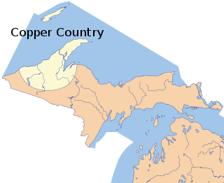
The Copper Country is an area in the Upper Peninsula of Michigan in the United States, including Keweenaw County, Michigan, Houghton, Baraga and Ontonagon counties as well as part of Marquette County. The area is so named as copper mining was prevalent there from 1845 until the late 1960s, with one mine continuing through 1995. In its heyday in the latter half of the 19th century and the early 20th century, the area was the world's greatest producer of copper.
M-26 is a 96.355-mile-long (155.068 km) state trunkline highway in the U.S. state of Michigan, running from two miles (3.2 km) east of Rockland to its junction with US Highway 41 (US 41) in Copper Harbor. It generally runs southwest-to-northeast in the western half or Michigan's Upper Peninsula. The northernmost segment, which closely parallels the shore of Lake Superior on the west side of the Keweenaw Peninsula, is highly scenic.

Eagle Harbor is an unincorporated community and census-designated place located on the north side of the Keweenaw Peninsula within Eagle Harbor Township, Keweenaw County in the U.S. State of Michigan. Its population was 69 as of the 2020 census. M-26 passes through this community. This hamlet was especially popular with the sailors in days past, as it had a good steamboat landing and is about equally distant from Sault Sainte Marie, Michigan, and Duluth, Minnesota. It was the first stop for supplies for the many boats on Lake Superior.

The Keweenaw Waterway is a partly natural, partly artificial waterway which cuts across the Keweenaw Peninsula of Michigan; it separates Copper Island from the mainland. Parts of the waterway are variously known as the Keweenaw Waterway, Portage Canal, Portage Lake Canal, Portage River, Lily Pond, Torch Lake, and Portage Lake. The waterway connects to Lake Superior at its north and south entries, with sections known as Portage Lake and Torch Lake in between. The primary tributary to Portage Lake is the Sturgeon River.
Keweenaw National Historical Park is a unit of the U.S. National Park Service. Established in 1992, the park celebrates the life and history of the Keweenaw Peninsula in the Upper Peninsula of the U.S. state of Michigan. As of 2009, it is a partly privatized park made up of two primary units, the Calumet Unit and the Quincy Unit, and 21 cooperating "Heritage Sites" located on federal, state, and privately owned land in and around the Keweenaw Peninsula. The National Park Service owns approximately 1,700 acres (690 ha) in the Calumet and Quincy Units. Units are located in Baraga, Houghton, Keweenaw, and Ontonagon counties.

This is a list of the National Register of Historic Places listings in Houghton County, Michigan.
Gregoryville is a small hamlet located on Torch Lake in Schoolcraft Township, near Lake Linden, in Houghton County, Michigan. The hamlet was more of a company town that arose out of the Joseph Gregoire lumber interests. Mr. Gregoire only hired French-Canadians to work for him, hence his title, "Father of the French Canadians."

The Bosch Brewing Company was a small brewery on the Keweenaw Peninsula, in the western part of the Upper Peninsula of the state of Michigan, United States. The company operated under different names from 1874 to 1973.

The Houghton Micropolitan Statistical Area, as defined by the United States Census Bureau, is an area consisting of two counties in the Upper Peninsula of Michigan, specifically the Keweenaw Peninsula, anchored by the city of Houghton.

The Gull Rock Light Station is an active lighthouse located on Gull Rock, just west of Manitou Island, off the tip of Michigan's Keweenaw Peninsula in Lake Superior. The light was listed on the National Register of Historic Places in 1984, even as its condition deteriorated, resulting in its placement on the Lighthouse Digest Doomsday List.

Toivola is an unincorporated community in Houghton County, Michigan, United States. The far-flung rural community is divided between Stanton Township, Adams Township, and Bohemia Township. It is found along M-26, 8 miles (13 km) southwest of South Range, 16 miles (25.7 km) from Houghton, and 35 miles (56 km) from Ontonagon. Toivola has a post office with ZIP code 49965. The community's historic industries include mainly agrarian uses and lumbering.
The Lac La Belle and Calumet Railroad was an American, 3 ft narrow gauge railroad that operated in the Keweenaw Peninsula, or the extreme northern Upper Peninsula of Michigan. The line was owned by Conglomerate Mining and ran between a stamp mill at Lac La Belle and the Mendota, Delaware, and Clark copper mines from 1883 to 1888, when poor economic conditions forced the line's closure.
Clarence J. Monette was a prolific author and historian from Michigan's Copper Country, writing extensively on Copper Country history. He has published more than sixty books and has written numerous outdoor survival guides.
The Calumet Aristocrats was the final moniker of the minor league baseball teams based in Laurium, Michigan between 1890 and 1907. The city was called "Calumet" in the era. Calumet teams played as members of the Upper Peninsula League in 1890 and 1891, Copper Country Soo League in 1904 and 1905 and Northern-Copper Country League in 1906 and 1907.

