
Rock Creek Park is a large urban park that bisects the Northwest quadrant of Washington, D.C. The park was created by an Act of Congress in 1890 and today is administered by the National Park Service. In addition to the park proper, the Rock Creek administrative unit of the National Park Service administers various other federally owned properties in the District of Columbia located to the north and west of the National Mall, including Meridian Hill Park on 16th Street, N.W., the Old Stone House in Georgetown, and certain of the Fort Circle Parks, a series of batteries and forts encircling the District of Columbia for its defense during the U.S. Civil War.

Georgetown is a historic neighborhood and commercial district of Washington, D.C., in Northwest D.C., situated along the Potomac River. Founded in 1751 in the Province of Maryland, the port of Georgetown predated the establishment of the federal district and the City of Washington by 40 years. Georgetown remained a separate municipality until 1871 when the United States Congress created a new consolidated government for the whole District of Columbia. A separate act, passed in 1895, specifically repealed Georgetown's remaining local ordinances and renamed Georgetown's streets to conform with those in the City of Washington.

The Manhattan Bridge is a suspension bridge that crosses the East River in New York City, connecting Lower Manhattan at Canal Street with Downtown Brooklyn at the Flatbush Avenue Extension. The main span is 1,480 ft (451 m) long, with the suspension cables being 3,224 ft (983 m) long. The bridge's total length is 6,855 ft (2,089 m). It is one of four toll-free vehicular bridges connecting Manhattan Island to Long Island; the nearby Brooklyn Bridge is just slightly further downtown, while the Queensboro and Williamsburg bridges are to the north.
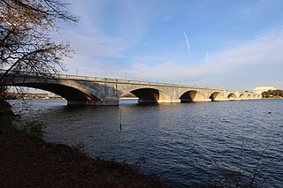
The Arlington Memorial Bridge, often shortened to Memorial Bridge, is a Neoclassical masonry, steel, and stone arch bridge with a central bascule that crosses the Potomac River at Washington, D.C., the capital of the United States. First proposed in 1886, the bridge went unbuilt for decades thanks to political quarrels over whether the bridge should be a memorial, and to whom or what. Traffic problems associated with the dedication of the Tomb of the Unknown Soldier in November 1921 and the desire to build a bridge in time for the bicentennial of the birth of George Washington led to its construction in 1932.
The Rock Creek and Potomac Parkway, informally called the Rock Creek Parkway, is a parkway maintained by the National Park Service as part of Rock Creek Park in Washington, D.C. It runs next to the Potomac River and Rock Creek in a generally north–south direction, carrying four lanes of traffic from the Lincoln Memorial and Arlington Memorial Bridge north to a junction with Beach Drive near Connecticut Avenue at Calvert Street, N.W., just south of the National Zoological Park.

The George Washington Memorial Parkway, colloquially the G.W. Parkway, is a 25-mile-long (40 km) parkway that runs along the south bank of the Potomac River from Mount Vernon, Virginia, northwest to McLean, Virginia, and is maintained by the National Park Service (NPS). It is located almost entirely within Virginia, except for a short portion of the parkway northwest of the Arlington Memorial Bridge that passes over Columbia Island within the District of Columbia.
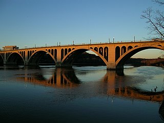
The Francis Scott Key Bridge, more commonly known as the Key Bridge, is a six-lane reinforced concrete arch bridge conveying U.S. Route 29 (US 29) traffic across the Potomac River between the Rosslyn neighborhood of Arlington County, Virginia, and the Georgetown neighborhood of Washington, D.C. Completed in 1923, it is Washington's oldest surviving road bridge across the Potomac River.

Connecticut Avenue is a major thoroughfare in the Northwest quadrant of Washington, D.C., and suburban Montgomery County, Maryland. It is one of the diagonal avenues radiating from the White House, and the segment south of Florida Avenue was one of the original streets in Pierre (Peter) Charles L'Enfant's plan for Washington. A five-mile segment north of Rock Creek was built in the 1890s by a real-estate developer.

The Montrose Park is a public park, owned by the federal government, located in the 3000 block of R Street, Northwest, Washington, D.C., in the Georgetown neighborhood. It is located between Dumbarton Oaks Park and Oak Hill Cemetery. Both Montrose Park and Dumbarton Oaks Park were jointly listed on the National Register of Historic Places on May 28, 1967. Montrose Park obtained an individual listing in 2007. In addition to a large children's play area in the back of the park, there are two sets of tennis courts, as well as open space with footwalks and trails which lead into Rock Creek Park.
The Dumbarton Oaks Park is a public park, located in the 3100 block of R Street, Northwest, Washington, D.C., in the Georgetown neighborhood. Access is via Lovers' Lane from R Street, east of 32nd Street. It is located near Dumbarton Oaks, Montrose Park, and Oak Hill Cemetery. It is part of the Georgetown Historic District.

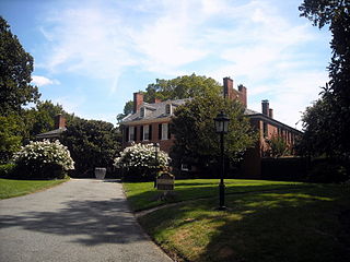
Dumbarton House is a Federal style house located in the Georgetown neighborhood of Washington, D.C. It was completed around 1800. Its first occupant was Joseph Nourse, the first Register of the Treasury. Dumbarton House, a federal period historic house museum, stands on approximately an acre of gardens on the northern edge of Georgetown, District of Columbia. The house is listed on the National Register of Historic Places. Displaying a fine collection of period decorative arts, it gives the visitor a concrete sense of a substantial private residence in the early 1800s. Constructed in 1798–99, the house was a private residence until The National Society of The Colonial Dames of America (NSCDA) purchased it for its headquarters in 1928 and gave it the name it has today. In addition to meeting its administrative needs, the NSCDA wanted to illustrate domestic life in Georgetown in the early federal period. To achieve this, its two principal floors were opened to the public as a house museum in 1932, on the 200th anniversary of the birth of George Washington.

Frankford Creek is a minor tributary of the Delaware River in southeast Pennsylvania. It derived its name from the nearby town of Frankford, Philadelphia County. The stream originates as Tookany Creek at Hill Crest in Cheltenham Township and meanders eastward, then southeastward, throughout Cheltenham Township, until a sharp bend near the Philadelphia border at Lawncrest, where the place names Toxony and Tookany were used in historic times; the stream is still known as Tookany Creek in this region, where it flows southwest. Turning south into Philadelphia at the crotch of Philadelphia's V-shaped border, the creek is called Tacony Creek; from here southward, it is considered the informal boundary separating Northeast Philadelphia from the rest of the city. The Philadelphia neighborhoods of Olney and Feltonville lie on the western side of the stream in this area while Northwood, Lawncrest, Summerdale, and Frankford lie on the eastern side. It continues to be called the Tacony at least until the smaller Wingohocking Creek merges with it in Juniata Park, within the city-owned golf course. Beyond Castor Avenue it is known as Frankford Creek until the stream's confluence with the Delaware River in the Bridesburg neighborhood of Philadelphia. The section of stream known as Frankford Creek is 3.1 miles (5.0 km) long, and the upstream section known as Tacony Creek, from Hill Crest, is 11.1 miles (17.9 km) long.
The streets and highways of Washington, D.C., form the core of the surface transportation infrastructure in Washington, D.C., the federal capital of the United States. Given that it is a planned city, the city's streets follow a distinctive layout and addressing scheme. There are 1,500 miles (2,400 km) of public roads in the city, of which 1,392 miles (2,240 km) are owned and maintained by city government.

The Aqueduct Bridge was a bridge between Georgetown, Washington, D.C., and Rosslyn, Virginia. It was built to transport cargo-carrying boats on the Chesapeake and Ohio Canal in Georgetown across the Potomac River to the Alexandria Canal. The same eight piers supported two different bridges: a wooden canal bridge and an iron truss bridge carrying a roadway and an electric trolley line. The bridge was closed in 1923 after the construction of the nearby Key Bridge. The shuttered Aqueduct Bridge was demolished in 1933 though its arched, stone abutment on the Georgetown (north) end is still present and overseen by the National Park Service as an historic site.

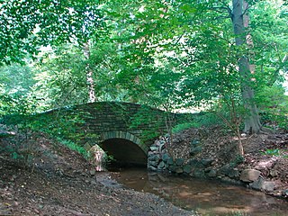
The Pennsylvania Avenue Bridge conveys Pennsylvania Avenue across Rock Creek and the adjoining Rock Creek and Potomac Parkway, between the neighborhoods of Georgetown and Foggy Bottom in Northwest Washington, D.C. Pennsylvania Avenue terminates at M Street immediately west of the bridge.
Evermay is a historic Federal architecture-style house at 1623 28th Street, Northwest, Washington, D.C., in the Georgetown neighborhood. The property originally extended south to Q Street, but the other houses were divided from the property.

Western Avenue is one of three boundary streets between Washington, D.C., and the state of Maryland. It follows a southwest-to-northeast line, beginning at Westmoreland Circle in the south and ending at Oregon Avenue NW in the north. It is roughly 3.5 miles (5.6 km) in length. First proposed in 1893, it was constructed somewhat fitfully from about 1900 to 1931.
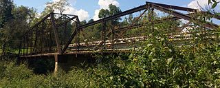
The Powell Bridge is a National Register of Historic Places site that crosses Big Sugar Creek near the community of Powell, Missouri, a rural hamlet in McDonald County, Missouri in the Ozark Mountains region. The bridge was built by the East St. Louis Bridge Co. and was opened to traffic on August 16, 1915. The single-lane pin-connected Pratt through truss was open to vehicular traffic from 1915 until a new two-lane bridge was built and opened beside it in 2015. It is currently owned by the Powell Historic Preservation Society and is one of three sites in McDonald County on the National Register of Historic Places, which also includes the Old McDonald County Courthouse. The community of Powell itself is best known as the home of famed gospel writer Albert E. Brumley.

The Rock Creek Trails are a series of trails through the Rock Creek valley and along the Potomac River in Washington, DC and Montgomery County, MD. The main route extends 22 miles from Lake Needwood in Maryland to the Inlet Bridge in Washington, DC, with a loop in the north part of Rock Creek Park and other trails through the Klingle Valley, Turkey Branch Valley and along the North Branch of Rock Creek. There are three separate trails that make up the main Rock Creek Trail route and others that connect to it. Along the Potomac River from Arlington Memorial Bridge to Rock Creek is a section sometimes called the Shoreline Trail.


