Solomon Islands is a nation in the South Pacific Ocean, that lies east of Papua New Guinea.

New Georgia Sound is the sound in the New Georgia Islands region that runs approximately southeast/northwest through the middle of the Solomon Islands archipelago in the Southern Pacific Ocean and Melanesia.

The Asiatic–Pacific Campaign Medal is a United States military award of the Second World War, which was awarded to any member of the United States Armed Forces who served in the Asiatic-Pacific Theater from 1941 to 1945. The medal was created on November 6, 1942 by Executive Order 9265 issued by President Franklin D. Roosevelt. The medal was designed by Thomas Hudson Jones; the reverse side was designed by Adolph Alexander Weinman which is the same design as used on the reverse of the American Campaign Medal and European-African-Middle Eastern Campaign Medal.

Álvaro de Mendaña y Neira was a Spanish navigator. Born in Congosto, in El Bierzo Region (León), he was the nephew of Lope García de Castro, viceroy of Peru. He is best known for the two voyages of discovery he led into the Pacific in 1567 and 1595 in search of Terra Australis.
Solomon Islands is divided into nine provinces. The national capital, Honiara, on the island of Guadalcanal, is separately governed as the islands' Capital Territory.

The Central Province is one of the provinces of Solomon Islands, covering the Russell Islands, Nggela Islands and Savo Island. Its area comprises 615 square kilometres and had a population of 26,051 as of 2009. The capital is Tulagi.

Isabel Province is one of the provinces of Solomon Islands. The province had a population of around 26,158 in 2009., mostly concentrated on the main island, Santa Isabel Island. The capital of the province is Buala on Santa Isabel Island, which has scheduled airline services to Honiara on Solomon Airlines from Fera Airport, on Fera Island, a 15-minute boat ride from Buala.
The Northern Solomons were the more northerly group of islands in the Solomon Islands archipelago over which Germany declared a protectorate in 1885. Initially the German Solomon Islands Protectorate included Choiseul, Santa Isabel, the Shortlands and Ontong Java Islands, but in 1900 these islands were transferred to the British Solomon Islands Protectorate. The largest of the Solomon Islands, Bougainville, continued under German administration until World War I when it fell to Australia, and after the war, it formally passed to Australian jurisdiction under a League of Nations mandate.

In human mitochondrial genetics, haplogroup B is a human mitochondrial DNA (mtDNA) haplogroup.

The Central Solomon languages are the four Papuan languages spoken in the state of the Solomon Islands.
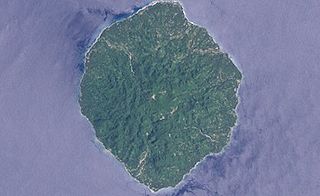
San Jorge Island is the second largest island in the Isabel Province, Solomon Islands.

Islam is a minority religion in the Solomon Islands. The religion first entered the country in 1987, when a Ghanaian missionary belonging to the Ahmadiyya movement visited Guadalcanal island on a reconnaissance trip lasting three years. Today, there are two major denominations in the country - Ahmadi Muslims and Sunni Muslims. According to a 2007 report by the United States Department of State's International Religious Freedom Report, there are approximately 350 Muslims in the country. However, different reports suggest that there may be 1000 Ahmadi Muslims in the country alone.
Sikopo is an island in the Solomon Islands; part of the Arnarvon Islands in Isabel Province. It lies in Manning Strait, which is between Choiseul Island and Santa Isabel Island, and which connects New Georgia Sound to the Pacific. The strait is named for Captain Edward Manning, of Pitt, who was the first European to sail through the straits and chart it in 1792.
Central Solomons was a single-member constituency of the Legislative Council of the Solomon Islands. It was created in 1967 and abolished in 1970 when the Governing Council was created. Its sole elected member, John Plant Hoka stood for re-election in the Ngella/Savo/Russells constituency in the 1970 elections.
John Plant Hoka was a Solomon Islands politician.
East Isabel was a single-member constituency of the Legislative Assembly and National Parliament of Solomon Islands between 1976 and 1993. Located on Santa Isabel Island, it replaced the East Isabel/Savo constituency, and was succeeded by Gao/Bugotu and Maringe/Kokota.
Gao/Bugotu is a single-member constituency of the National Parliament of Solomon Islands. Located on Santa Isabel Island, it was established in 1993 when the National Parliament was expanded from 38 to 47 seats.