East Liverpool, Ohio

Last updated

East Liverpool, Ohio
East 5th Street Historic District, East Liverpool, Ohio July 2022.jpg
Nickname(s): 
Pottery Capital of the World, Crockery City
Motto: 
"We're Open for Business"
Columbiana County Ohio incorporated and unincorporated areas East Liverpool highlighted.png
Location of East Liverpool in Columbiana County and in the State of Ohio
Coordinates: 40°37′43″N80°34′19″W / 40.62861°N 80.57194°W / 40.62861; -80.57194
CountryUnited States
State Ohio
County Columbiana
Founded1802
Named for Liverpool, England
Government
  Type Mayor–council
  MayorRobert J. Smith [1]
  Council PresidentJohn A. Torma [1]
Area
[2]
  Total4.90 sq mi (12.68 km2)
  Land4.70 sq mi (12.18 km2)
  Water0.20 sq mi (0.51 km2)
Elevation
[3]
965 ft (294 m)
Population
 (2020)
  Total9,958
  Density2,118.27/sq mi (817.86/km2)
Time zone UTC−5 (Eastern (EST))
  Summer (DST) UTC−4 (EDT)
ZIP code
43920
Area code 330, 234
FIPS code 39-23730 [4]
GNIS feature ID1085891 [3]
School District East Liverpool City SD
Website http://www.eastliverpool.com/

East Liverpool is a city in southeastern Columbiana County, Ohio, United States. The population was 9,958 at the 2020 census. [5] It lies along the Ohio River within the Upper Ohio Valley and borders Pennsylvania to the east and West Virginia to the south. East Liverpool is included in the Salem micropolitan area, about 34 miles (55 km) from both Youngstown and downtown Pittsburgh.

Contents

East Liverpool is notable for its pottery industry, which was at one time the largest in the United States. [6] Holly Black's ceramic-themed novel Doll Bones is set in East Liverpool.

History

C.C. Thompson Pottery Co. c. 1912 C.C. Thompson Pottery Co. (16255673816).jpg
C.C. Thompson Pottery Co. c.1912

Native American petroglyphs exist in the area surrounding East Liverpool, including on Babbs Island and near the Little Beaver Creek. [7] Before the arrival of European Americans, Mingo, Lenape, and Wyandot peoples lived in the area until the Battle of Fallen Timbers led to the Ohio Country's settlement. The Public Land Survey System of the United States was established by Congressional legislation in 1785 in order to provide an orderly mechanism for opening the Northwest Territory for settlement. The ordinance directed the Geographer of the United States, Thomas Hutchins, to survey an initial east–west base line. Hutchins began in 1786, using as his starting point a stake on north bank of the Ohio River placed by a 1785 survey team from Virginia and Pennsylvania to fix their common north–south boundary. Hutchins' work, completed in 1787, established the Seven Ranges. This survey is believed to be "the first mathematically designed system and nationally conducted cadastral survey in any modern country." [8]

East Liverpool traces its founding to 1798, when Irish immigrant Thomas Fawcett purchased 1,100 acres of land along the Ohio River in what was then Jefferson County. In 1802, he platted the town of St. Clair, named for Governor Arthur St. Clair of the Northwest Territory. [9] It was called Fawcettstown for a time, before being renamed Liverpool in 1816, after Liverpool, England. Over its first few decades, a grist mill, multiple stores, and wharves opened in the town. [10] The first schoolhouse opened in 1820, and the first religious center opened in 1834 when an Episcopal Church was established on a 4th Street site provided by town developers. [10] Liverpool was incorporated as East Liverpool in 1834 when Liverpool Township in Medina County objected to possible confusion. [10]

Odd Fellows Temple as depicted in 1910 Odd Fellows' Temple (16281596245).jpg
Odd Fellows Temple as depicted in 1910

Although Pittsburgh-based entrepreneurs invested in the town, it was smaller during this period than nearby New Lisbon and Wellsville. The arrival of English potter James Bennett in 1839 brought the establishment of the first bottle kiln site in East Liverpool, launching the town's largest industry and bringing in multiple waves of Western European immigration throughout the late 19th century. [10] Another large employer outside of that industry was the Crucible Steel Company in nearby Midland, Pennsylvania. By 1880, East Liverpool had grown to be the largest city in the county. [4] In 1905, the first city hospital opened. [11] As of 1914, East Liverpool was served by the Cleveland and Pittsburgh Railroad. [12] On October 22, 1934, local police and FBI agents led by Melvin Purvis shot and killed notorious bank robber Pretty Boy Floyd in a cornfield north of town after Floyd fled East Liverpool, and his body was returned to the town for embalming.

In the 1960s, much of the downtown area was cleared to make way for the 4-lane expansion of Ohio State Route 11. [13] The city reached its peak population of more than 26,000 in 1970, but its pottery industry had already begun to decline by the mid-1960s. As with other industries, production moved to developing countries where labor costs were cheaper. This cost many jobs and, ultimately, population in the Upper Ohio Valley area, as people moved away in search of work. Furthermore, many of the city's downtown businesses withdrew to strip malls in nearby Calcutta or left the area outright.

The former East Liverpool Post Office (1909) now houses the Museum of Ceramics Museum of Ceramics, East Liverpool, Ohio July 2022.jpg
The former East Liverpool Post Office (1909) now houses the Museum of Ceramics

In 1963, a toxic waste incinerator was erected at an S. H. Bell Company warehouse in East Liverpool. Local investors believed the incinerator could be an alternative to the declining ceramics industry. [14] In 2008, concerns were raised about toxic particles affecting East Liverpool residents' health, [15] particularly manganese, [15] which was found in high concentrations. [15] East Liverpool residents were found to have higher than normal levels of manganese, cadmium, and lead in their blood, [16] and the community was considered to be in a health crisis due to the presence of these toxic elements. [17] [18] [19] Government agencies worked with S. H. Bell to decrease the toxic metals being released into the surrounding air and land, and from 2006 to 2013 air quality improved. In 2014, hazardous and toxic particles in air quality assessments increased. [20] Activism to reduce the toxic waste began. [21] [22] In 2005, the EPA declared the area surrounding the incinerator a "potential environmental justice area". [22]

In the mid-1990s, the city renovated its downtown district. To improve its urban design, it installed Depression-era lightposts, developed a new center called Devon's Diamond, and reconstructed the old high school's clock tower.[ citation needed ] In 2010, East Liverpool lost its position as the most populous city in the county to Salem after 130 years and was later withdrawn from being a principal city in the micropolitan area. [4]

Pottery industry

Pitcher, c. 1861, by East Liverpool Porcelain Works Pitcher MET DT7372.jpg
Pitcher, c.1861, by East Liverpool Porcelain Works

The potteries of East Liverpool became the national center of ceramic toilet and table wares, with 85 firms operating at one time or another making two-thirds of the national output from 1880 to 1950. East Liverpool's pottery district encompasses East Liverpool and the surrounding towns of Wellsville, Ohio, and Chester and Newell, West Virginia, directly across the Ohio River. In 1887, East Liverpool had 21 general ware potteries that employed 2,558 operatives. By 1923 the 17 firms had 7,000 employees and operated 270 kilns, with $25,000,000 in annual output. [23]

Englishman James Bennett established the industry in 1839, making use of good transportation and rich local clays. It quickly became the community's leading industry. East Liverpool became known as "The Crockery City." Potters from Staffordshire, England, began pouring into East Liverpool, attracted by higher wages and the prospect of land ownership. By 1879, there were 24 potteries in East Liverpool, nearly all operated by English immigrants. As late as 1900, East Liverpool remained "essentially a transplanted potting town of Englishmen". [24] Until the turn of the century about 85% percent of the population could trace its heritage to England. [25] After the English, the second largest ethnic group in East Liverpool were German settlers. [26] From 1870 to 1890, the city more than doubled in population each decade as it attracted new industrial workers with the growth of the pottery industry. By 1910, its population exceeded 20,000. At various times, some of the largest potteries included the East Liverpool Pottery, Knowles, Taylor & Knowles; Taylor, Smith & Taylor; The Hall China Company, and Homer Laughlin China Company.

Of these potteries, two continue to operate in the area: the American Mug & Stein Company and the Fiesta Tableware Company, formerly Homer Laughlin. In the mid-19th century, East Liverpool also produced most of the yellowware pottery used in the United States. Among the most famous of East Liverpool's ceramics was the porcelain known as Lotus Ware. Produced by Knowles, Taylor & Knowles in the 1890s, this Moorish- and Persian-influenced artware swept the competition at the 1893 World's Fair in Chicago. The Museum of Ceramics in downtown East Liverpool has the world's largest public display of Lotus Ware.

Geography

East Liverpool vicinity East-liverpool-ohio-aerial.jpg
East Liverpool vicinity

According to the United States Census Bureau, the city has an area of 4.76 square miles (12.33 km2), of which 4.56 square miles (11.81 km2) is land and 0.20 square miles (0.52 km2) is water. [27]

Neighborhoods include:

Demographics

Historical population
CensusPop.Note
1830 136
1840 503269.9%
1850 98796.2%
1860 1,30832.5%
1870 2,10560.9%
1880 5,568164.5%
1890 10,95696.8%
1900 16,48550.5%
1910 20,38723.7%
1920 21,4115.0%
1930 23,3299.0%
1940 23,5551.0%
1950 24,2172.8%
1960 22,306−7.9%
1970 26,24317.6%
1980 16,517−37.1%
1990 13,654−17.3%
2000 13,089−4.1%
2010 11,195−14.5%
2020 9,958−11.0%
Sources: [4] [28] [29]

2010 census

As of the census [30] of 2010, there were 11,195 people, 4,601 households, and 2,892 families residing in the city. The population density was 2,455.0 inhabitants per square mile (947.9/km2). There were 5,316 housing units at an average density of 1,165.8 per square mile (450.1/km2). The racial makeup of the city was 91.7% White, 4.6% African American, 0.2% Native American, 0.2% Asian, 0.3% from other races, and 3.0% from two or more races. Hispanic or Latino of any race were 1.1% of the population.

There were 4,601 households, of which 33.4% had children under the age of 18 living with them, 36.0% were married couples living together, 20.1% had a female householder with no husband present, 6.7% had a male householder with no wife present, and 37.1% were non-families. 31.9% of all households were made up of individuals, and 11.9% had someone living alone who was 65 years of age or older. The average household size was 2.39 and the average family size was 2.97.

The median age in the city was 37.6 years. 25.4% of residents were under the age of 18; 9.5% were between the ages of 18 and 24; 24% were from 25 to 44; 26.5% were from 45 to 64; and 14.6% were 65 years of age or older. The gender makeup of the city was 47.6% male and 52.4% female.

2000 census

As of the census [4] of 2000, there were 13,089 people, 5,261 households, and 3,424 families residing in the city. The population density was 3,010.3 inhabitants per square mile (1,162.3/km2). There were 5,743 housing units at an average density of 1,320.8 per square mile (510.0/km2). The racial makeup of the city was 92.85% White, 4.81% African American, 0.24% Native American, 0.08% Asian, 0.05% Pacific Islander, 0.21% from other races, and 1.76% from two or more races. Hispanic or Latino of any race were 0.72% of the population.

There were 5,261 households, out of which 32.9% had children under the age of 18 living with them, 43.5% were married couples living together, 16.6% had a female householder with no husband present, and 34.9% were non-families. 30.3% of all households were made up of individuals, and 13.5% had someone living alone who was 65 years of age or older. The average household size was 2.44 and the average family size was 3.01.

In the city the population was spread out, with 27.1% under the age of 18, 8.8% from 18 to 24, 27.3% from 25 to 44, 20.8% from 45 to 64, and 16.0% who were 65 years of age or older. The median age was 36 years. For every 100 females, there were 86.5 males. For every 100 females age 18 and over, there were 81.8 males.

The median income for a household in the city was $23,138, and the median income for a family was $27,500. Males had a median income of $27,346 versus $18,990 for females. The per capita income for the city was $12,656. About 21.5% of families and 25.2% of the population were below the poverty line, including 35.2% of those under age 18 and 13.0% of those age 65 or over.

EastLiverpool01.JPG
East Liverpool viewed from the east.

Arts and culture

East Liverpool's Carnegie Public Library was the first Carnegie library in Ohio. Carnegie Library, East Liverpool, Ohio July 2022 (2).jpg
East Liverpool's Carnegie Public Library was the first Carnegie library in Ohio.

Events

Since 1970, the annual Tri-State Pottery Festival in June has celebrated the local ceramics industry with local pottery exhibits, games, amusement rides, food vendors, and live entertainment. [31] Starting in 2021, the First Fridays on Fifth event series has taken place on the first Friday of each month from May to October, hosting local crafts, musicians, and food vendors. [32]

Library

The Carnegie Public Library was funded by industrialist and philanthropist Andrew Carnegie, whose uncle lived in East Liverpool. Along with the Steubenville library, it was the first of the Carnegie libraries in Ohio. [33] Designed by the local A. W. Scott, it was built with Roman mottled buff-brown brick trimmed with white tile, with construction starting in 1900. [33] The lobby is of ceramic mosaic, the wainscoting of Italian marble and the solid brass hardware. The library opened on May 8, 1902, with Gertrude A. Baker of Mount Vernon, Ohio serving as its first librarian. The library underwent two renovations over the 1950s and early 1990s. [33]

Historic places

The Richard L. Cawood Residence (1923) is an example of Renaissance architecture and one of numerous city buildings on the National Register of Historic Places. Richard L. Cawood Residence, East Liverpool.jpg
The Richard L. Cawood Residence (1923) is an example of Renaissance architecture and one of numerous city buildings on the National Register of Historic Places.

Due to being the home of a large industry with many wealthy business owners, 16 different properties and three historic districts are listed on the National Register of Historic Places, in addition to the Beginning Point of the U.S. Public Land Survey, the only National Historic Landmark in Columbiana County. [34]

The Diamond Historic District is at the one-sided traffic diamond between Market Street and East Sixth Street. The area is triangular, bounded by three roads. Buildings at the Diamond date back to 1884. [35] The East Fifth Street Historic District consists of three blocks of downtown East Liverpool along East Fifth street between Market Street and Broadway, listed due to its examples of Neoclassical architecture. [36] East Liverpool Downtown Historic District covers the whole of downtown in 22 acres, and is noted for its Italianate and Second Empire architecture as well as its prominence as a commercial center in East Liverpool's history. [36]

Many historic properties in East Liverpool were the homesteads of prominent business owners throughout the late 19th century. These include the Cassius Clark Thompson House (1876), Ikirt House (1888), Homer Laughlin House (1882), Godwin-Knowles House (1890), and the Richard L. Cawood Residence (1923), all of unique architectural styles. [34]

The remaining structures on the listing are large, multi-story businesses that had historical significance in East Liverpool's economy and community during the 20th century, such as the original East Liverpool Post Office (1909), East Liverpool Pottery (1844), Andrew Carnegie's Public Library (1902), the original YMCA (1913), the Civil Works Administration's City Hall (1934), the Elks Club building (1916), Odd Fellows Temple (1907), Mary A. Patterson Memorial building (1924), Potters Savings and Loan (1904), the first Potters National Bank (1881), and the Travelers Hotel (1907). [34]

Parks and recreation

There are two public parks within East Liverpool city limits. Thompson Park was established after composer Will Lamartine Thompson donated 100 acres of land to the city in 1899. [37] It opened in 1900 as a green space to get away from the industry of the city. [38] It has been open ever since, and amenities include picnic pavilions, a swimming pool, a football field, a baseball field, a disc golf course, a playground and walking trails. The Broadway Wharf on the Ohio River includes a small public park and boat launch. [39]

Sports

The semipro East Liverpool Potters basketball team of the Central Basketball League played in the city from 1906 to 1909, and an East Liverpool Potters minor league baseball club was fielded from 1906 to 1912. The East Liverpool Country Club has a 9-hole golf course designed by Willie Park, Jr., that opened on July 14, 1921. [40]

Government

East Liverpool operates under a mayor–council government. Eight council members are elected as a legislature for 2-year terms, comprising four separate wards, three at-large districts, and a council president. [1] In addition, an independently elected mayor serves as an executive. [1] The current mayor is Robert J. Smith, and the current council president is John A. Torma. [1] The mayor, auditor, treasurer, and law director are all elected to 4-year terms.

Education

John J. Purinton Hall, Kent State University at East Liverpool Kent State University, East Liverpool, Ohio July 2022.jpg
John J. Purinton Hall, Kent State University at East Liverpool

Primary and secondary

Children in East Liverpool are served by the public East Liverpool City School District. The current schools serving the city are La Croft Elementary School (grades K-4), North Elementary School (grades K-4), Westgate Middle School (grades 5-6), and East Liverpool Junior/Senior High School (grades 7-12).

Private schools include the East Liverpool Christian School for grades K-12 and the Lincoln Park Performing Arts Charter School for grades 7-12. In addition, two online schools, Buckeye Online School for Success and Quaker Digital Academy, operate out of downtown. St. Aloysius School (K-8) operated for 130 years as a Roman Catholic School in the Diocese of Youngstown before closing on June 6, 2015. [41]

Postsecondary

Kent State University has been operating a satellite campus, Kent State University at East Liverpool, since 1965. In tandem with the Kent State Salem campus, more than 20 degrees are offered, including 12 bachelor's degrees. [42] New Castle School of Trades opened a downtown campus in 2016.

Media

East Liverpool was once home to several newspapers in the 1800s, but most were consolidated into The Review , which today serves chiefly southern Columbiana County and northern Hancock County. Additionally, the Morning Journal out of Lisbon reports in the area.

The radio station WOHI 1490 AM has broadcast from the city since December 1, 1949, and is marketed as a classic hits station. The city also had a station on the FM dial 104.3, WOGI, but its license was moved to Moon Township, Pennsylvania, in 2000 and now serves the Pittsburgh radio market. Both stations were launched by the former East Liverpool Broadcasting Company. [43]

Transportation

The Jennings Randolph Bridge connects to West Virginia via U.S. Route 30. Jennings Randolph Bridge.jpg
The Jennings Randolph Bridge connects to West Virginia via U.S. Route 30.

Highways

The following highways pass through East Liverpool:

Bridges

Since the 1890s, East Liverpool and the West Virginia communities of Chester and Newell have been connected by three different bridges spanning the Ohio River.

Notable people

Sister cities

East Liverpool has one sister city:

Related Research Articles

<span class="mw-page-title-main">Columbiana County, Ohio</span> County in Ohio, United States

Columbiana County is a county located in the U.S. state of Ohio. As of the 2020 census, the population was 101,877. The county seat is Lisbon and its largest city is Salem. Created in 1803, the county name is derived from that of 15th-century Italian explorer Christopher Columbus.

<span class="mw-page-title-main">Columbiana, Alabama</span> City in and county seat of Shelby County, Alabama

Columbiana is a city and the county seat of Shelby County, Alabama, United States. At the 2020 census, the population was 4,462.

<span class="mw-page-title-main">Seagrove, North Carolina</span> Town in North Carolina, United States

Seagrove is a town in Randolph County, North Carolina, United States. The population was 285 at the 2019 census. It was named after a railroad official when the area was connected by rail. In 2020, the center of population of North Carolina was located east of Seagrove.

<span class="mw-page-title-main">Calcutta, Ohio</span> Census-designated place in Ohio, United States

Calcutta is an unincorporated community and census-designated place in southeastern Columbiana County, Ohio, United States. The population was 3,941 at the 2020 census. Historically a rural town, Calcutta grew as businesses from neighboring East Liverpool moved into larger shopping centers clustered around Ohio State Route 170.

<span class="mw-page-title-main">East Palestine, Ohio</span> Village in Ohio, United States

East Palestine is a village in northeastern Columbiana County, Ohio, United States. The population was 4,761 at the 2020 census. Located on the state's border with Pennsylvania, East Palestine is about 20 miles (32 km) south of Youngstown and 40 miles (64 km) northwest of Pittsburgh. It is part of the Salem micropolitan area.

<span class="mw-page-title-main">Glenmoor, Ohio</span> Census-designated place in Ohio, United States

Glenmoor is an unincorporated community and census-designated place in southwestern St. Clair Township, Columbiana County, Ohio, United States. The population was 1,829 at the 2020 census. Glenmoor is located in the Salem micropolitan area and the greater Youngstown–Warren area.

<span class="mw-page-title-main">La Croft, Ohio</span> Census-designated place in Ohio, United States

La Croft is an unincorporated community and census-designated place (CDP) in Liverpool Township, Columbiana County, Ohio, United States. The population was 1,078 at the 2020 census. La Croft is located in the Salem micropolitan area and the greater Youngstown–Warren area.

<span class="mw-page-title-main">Lisbon, Ohio</span> Village in Ohio, United States

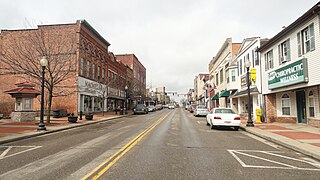
Lisbon is a village in and the county seat of Columbiana County, Ohio, United States, along the Little Beaver Creek. The population was 2,597 at the 2020 census. It is a part of the Salem micropolitan area, about 23 miles (37 km) southwest of Youngstown.

<span class="mw-page-title-main">Salem, Ohio</span> City in Ohio, United States

Salem is a city in northern Columbiana County, Ohio, United States. At the 2020 census, the city's population was 11,915. Extending into southern Mahoning County, it is the principal city of the Salem micropolitan area, which includes all of Columbiana County. It lies about 18 miles (29 km) southwest of Youngstown, 28 miles (45 km) east of Canton, and 60 miles (97 km) southeast of Cleveland.

<span class="mw-page-title-main">Salineville, Ohio</span> Village in Ohio, United States

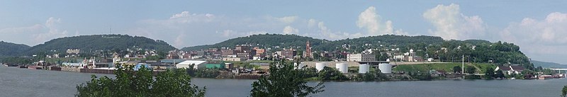
Salineville is a village in southwestern Columbiana County, Ohio, United States. The population was 1,206 at the 2020 census. It is part of the Salem micropolitan area, about 20 miles (32 km) northwest of Steubenville and 34 miles (55 km) southwest of Youngstown.

<span class="mw-page-title-main">Chesterland, Ohio</span> Census-designated place in Ohio, United States

Chesterland is a census-designated place (CDP) in Geauga County, Ohio, United States. As of the 2020 census, the CDP had a population of 7,074.

<span class="mw-page-title-main">Zanesville, Ohio</span> City in Ohio, United States

Zanesville is a city in and the county seat of Muskingum County, Ohio, United States. Located at the confluence of the Licking and Muskingum rivers, the city is approximately 52 miles (84 km) east of Columbus and had a population of 24,765 as of the 2020 census, down from 25,487 as of the 2010 census. Historically the state capital of Ohio from 1810 to 1812, Zanesville anchors the Zanesville micropolitan area and is part of the greater Columbus-Marion-Zanesville combined statistical area.

<span class="mw-page-title-main">Crooksville, Ohio</span> Village in Ohio, United States

Crooksville is a village in Perry County, Ohio, United States, along Moxahala Creek. The population was 2,418 at the 2020 census. It was the home of Hull pottery, one of the best known Ohio potteries.

<span class="mw-page-title-main">Midland, Pennsylvania</span> Borough in Pennsylvania, United States

Midland is a borough located along the Ohio River in western Beaver County, Pennsylvania, United States. As of the 2020 census, the population was 2,433. It is part of the Pittsburgh metropolitan area. Founded in 1906, it was initially a company town surrounding the Crucible Steel Company's Midland Works.

<span class="mw-page-title-main">Ohioville, Pennsylvania</span> Borough in Pennsylvania, United States

Ohioville is a borough in western Beaver County, Pennsylvania, United States. The population was 3,349 at the 2020 census. It is part of the Pittsburgh metropolitan area.

<span class="mw-page-title-main">Chester, West Virginia</span> City in West Virginia, United States

Chester is a city in northern Hancock County, West Virginia, United States, along the Ohio River. The population was 2,214 at the 2020 census. Located immediately south of Ohio and just west of Pennsylvania, Chester is the northernmost city in West Virginia. It is a part of the Weirton–Steubenville metropolitan area, and is home to the World's Largest Teapot.

<span class="mw-page-title-main">Newell, West Virginia</span> Census-designated place in West Virginia, United States

Newell is an unincorporated community and census-designated place in northern Hancock County, West Virginia, United States, along the Ohio River. The population was 1,203 at the 2020 census. It is part of the Weirton–Steubenville metropolitan area and is best known as the home to the Fiesta Tableware Company.

<span class="mw-page-title-main">Columbiana, Ohio</span> City in Ohio, United States

Columbiana is a city in northern Columbiana and southern Mahoning counties in the U.S. state of Ohio. The population was 6,559 at the 2020 census. It is part of the Salem micropolitan area and Youngstown–Warren metropolitan area.

<span class="mw-page-title-main">Mahoning Valley</span> Metropolitan area in Ohio, United States

The Youngstown–Warren, OH Metropolitan Statistical Area, typically known as the Mahoning Valley, is a metropolitan area in Northeast Ohio with Youngstown, Ohio, at its center. According to the U.S. Census Bureau, the metropolitan statistical area (MSA) includes Mahoning and Trumbull counties. As of the 2020 census, the region had a population of 430,591, making it the 125th-largest metro area in the country.

<span class="mw-page-title-main">East Rochester, Ohio</span> Census-designated place in Ohio, United States

East Rochester is an unincorporated community and census-designated place (CDP) in southern West Township, Columbiana County, Ohio, United States. The population was 224 as of the 2020 census. It lies along U.S. Route 30, and has a post office with the ZIP code 44625. It is a part of the Salem micropolitan area, about 20 miles (32 km) east of Canton.

References

  1. 1 2 3 4 5 "2023 General Election Results for Columbiana County" (PDF). Retrieved November 26, 2023.
  2. "ArcGIS REST Services Directory". United States Census Bureau. Retrieved September 20, 2022.
  3. 1 2 U.S. Geological Survey Geographic Names Information System: East Liverpool, Ohio
  4. 1 2 3 4 5 "U.S. Census website". United States Census Bureau . Retrieved January 31, 2008.
  5. "QuickFacts: East Liverpool city, Ohio". census.gov. Retrieved September 13, 2021.
  6. "History - Museum of Ceramics". Ohio History Central. Retrieved January 25, 2023.
  7. "Indian Mounds & Petroglyphs". East Liverpool Historical Society. Retrieved January 10, 2022.
  8. Mendinghall, Joseph S. (December 27, 1974). "National Register of Historic Places Inventory-Nomination: Beginning Point / Beginning Point of the U.S. Public Land Survey" (pdf). National Park Service.
  9. McCord, William B. (1905). History of Columbiana County, Ohio and Representative Citizens. Biographical Publishing Company. p. 286.
  10. 1 2 3 4 "Very Early East Liverpool, Ohio". East Liverpool Historical Society. Retrieved January 10, 2022.
  11. "Memorable East Liverpool Dates". East Liverpool Historical Society. Retrieved January 10, 2022.
  12. Beach, Chandler B.; McMurry, Frank Morton, eds. (1914). The New Student's Reference Work. Chicago: F.E. Compton and Company. p. 577. Retrieved August 31, 2014.
  13. "HOW EAST LIVERPOOL GOT HERE". East Liverpool Historical Society. Retrieved January 10, 2022.
  14. Shevory, Thomas (2007). "Introduction: East Liverpool and the Politics of Power". Toxic Burn: The Grassroots Struggle against the WTI Incinerator. University of Minnesota Press. pp. 1–30. ISBN   978-0-8166-4852-8. JSTOR   10.5749/j.ctttv9zz.4. Project MUSE   chapter 1278452.
  15. 1 2 3 "High Levels of Manganese in the East Liverpool air in Ohio". Agency for Toxic Substances and Disease Registry. January 26, 2021.
  16. Martin, Kaitlin Vollet; Sucharew, Heidi; Dietrich, Kim N.; Parsons, Patrick J.; Palmer, Christopher D.; Wright, Robert; Amarasiriwardena, Chitra; Smith, Donald R.; Haynes, Erin N. (November 2021). "Co-exposure to manganese and lead and pediatric neurocognition in East Liverpool, Ohio". Environmental Research. 202: 111644. Bibcode:2021ER....202k1644M. doi:10.1016/j.envres.2021.111644. PMC   8578304 . PMID   34246641.
  17. Kim, Yangho; Lobdell, Danelle T.; Wright, Chris W.; Gocheva, Vihra V.; Hudgens, Edward; Bowler, Rosemarie M. (May 2015). "Blood Metal Concentrations of Manganese, Lead, and Cadmium in Relation to Serum Ferritin Levels in Ohio Residents". Biological Trace Element Research. 165 (1): 1–9. doi:10.1007/s12011-014-0223-1. PMID   25578336. S2CID   17844438. ProQuest   1671990287.
  18. Bowler, Rosemarie M.; Kornblith, Erica S.; Gocheva, Vihra V.; Colledge, Michelle A.; Bollweg, George; Kim, Yangho; Beseler, Cheryl L.; Wright, Chris W.; Adams, Shane W.; Lobdell, Danelle T. (July 2015). "Environmental exposure to manganese in air: Associations with cognitive functions". NeuroToxicology. 49: 139–148. doi:10.1016/j.neuro.2015.06.004. PMC   4803288 . PMID   26096496.
  19. Bowler, Rosemarie M.; Beseler, Cheryl L.; Gocheva, Vihra V.; Colledge, Michelle; Kornblith, Erica S.; Julian, Jaime R.; Kim, Yangho; Bollweg, George; Lobdell, Danelle T. (January 2016). "Environmental exposure to manganese in air: Associations with tremor and motor function". Science of the Total Environment. 541: 646–654. Bibcode:2016ScTEn.541..646B. doi:10.1016/j.scitotenv.2015.09.084. PMC   4803294 . PMID   26437342.
  20. US EPA, REG 05 (October 7, 2016). "East Liverpool, Ohio and Glasgow Borough, Pennsylvania– Air Monitoring Data". www.epa.gov.{{cite web}}: CS1 maint: numeric names: authors list (link)
  21. "Trump card in the environmental fight: The children". National Catholic Reporter. Kansas City. 30 (16): 36. February 18, 1994. ProQuest   215338272.
  22. 1 2 Greene, Kristian Winfield, Ronnie (August 14, 2015). "Residents of Ohio town see 'environmental justice' as empty promise". Center for Public Integrity.{{cite web}}: CS1 maint: multiple names: authors list (link)
  23. Gates, William C.; Ormerod, Dana E. (1982). "The East Liverpool pottery district: Identification of manufacturers and marks". Historical Archaeology. 16 (1): 1–323. doi:10.1007/BF03374026. S2CID   163404422.
  24. William E. Van Vugt. British Buckeyes: The English, Scots, and Welsh in Ohio, 1700–1900. pp. 135–136, 137.
  25. Witt, Joan. "The People of East Liverpool". East Liverpool Historical Society.
  26. "ELHistSoc - the People of East Liverpool".
  27. "US Gazetteer files 2010". United States Census Bureau. Archived from the original on January 25, 2012. Retrieved January 6, 2013.
  28. "Number of Inhabitants: Ohio" (PDF). 18th Census of the United States. U.S. Census Bureau. 1960. Retrieved May 17, 2020.
  29. "Ohio: Population and Housing Unit Counts" (PDF). U.S. Census Bureau. Retrieved May 17, 2020.
  30. "U.S. Census website". United States Census Bureau . Retrieved January 6, 2013.
  31. Lehman, Liz (June 16, 2022). "52nd annual Tri-State Pottery Festival begins today". The Review . Retrieved January 17, 2023.
  32. "First Fridays on Fifth". TourismOhio. Retrieved January 17, 2023.
  33. 1 2 3 "A More Complete History". Carnegie Public Library; East Liverpool, Ohio. Carnegie Public Library. Retrieved January 17, 2023.
  34. 1 2 3 "National Register of Historic Places: Weekly List Actions" . Retrieved November 3, 2019.
  35. Cutter, William Richard, ed. (1922). American Biography: A New Cyclopedia; Volume 11. American historical society. p. 172. Retrieved May 24, 2012.
  36. 1 2 "National Register Information System". National Register of Historic Places . National Park Service. July 9, 2010.
  37. Archived March 15, 2012, at the Wayback Machine
  38. 1 2 3 Judith A Allison, Webmaster@eastliverpoolhistoricalsociety.org. "ELHistSoc – Memorable East Liverpool Dates". Eastliverpoolhistoricalsociety.org. Retrieved September 28, 2013.
  39. Bobby-Gilbert, Jo Ann (July 29, 2019). "East Liverpool's Broadway Wharf Gets a Facelift". The Business Journal. Retrieved January 19, 2023.
  40. "East Liverpool Country Club" . Retrieved January 19, 2023.
  41. "After 130 years, St. Aloysius School will close". The Review. April 2, 2015. Retrieved January 19, 2023.
  42. "Campuses". Kent.edu. Kent State University. 2012. Archived from the original on January 25, 2012. Retrieved January 26, 2012.
  43. "WOHI-FM First Air Date & Ownership" (PDF). Broadcasting Yearbook. 1960. pp. A-207. Retrieved August 17, 2012.
  44. "ELHistSoc -The Original Chester Bridge". www.eastliverpoolhistoricalsociety.org. Archived from the original on September 10, 2019. Retrieved January 17, 2022.
  45. Shuba. "East Liverpool, Hamlin have unique relationship". The Weirton Daily Times. Retrieved March 17, 2021.
  46. "Rest At Last: Death of Ex-Governor George Smith". St. Joseph Weekly Herald . St. Joseph, MO. July 21, 1881. p. 3 via Newspapers.com.
  47. "East Liverpool High School Sports History Trivia". eastliverpoolhistoricalsociety.org. East Liverpool Historical Society. Retrieved January 6, 2022.

Further reading