
Tropical Storm Allison was a tropical storm that devastated southeast Texas in June of the 2001 Atlantic hurricane season. An arguable example of the "brown ocean effect", Allison lasted unusually long for a June storm, remaining tropical or subtropical for 16 days, most of which was when the storm was over land dumping torrential rainfall. The storm developed from a tropical wave in the northern Gulf of Mexico on June 4, 2001, and struck the upper Texas coast shortly thereafter. It drifted northward through the state, turned back to the south, and re-entered the Gulf of Mexico. The storm continued to the east-northeast, made landfall on Louisiana, then moved across the southeast United States and Mid-Atlantic. Allison was the first storm since Tropical Storm Frances in 1998 to strike the northern Texas coastline.

Hurricane Ivan was a large, long-lived, Cape Verde hurricane that caused widespread damage in the Caribbean and United States. The cyclone was the ninth named storm, the sixth hurricane and the fourth major hurricane of the active 2004 Atlantic hurricane season.
Hurricane Frederic was an intense and damaging tropical cyclone that carved a path of destruction from the Lesser Antilles to Quebec, in particular devastating areas of the United States Gulf Coast. Though only five were killed directly, the US$1.77 billion in damage accrued by Frederic made it the Atlantic basin's costliest tropical cyclone on record at the time. Prior to its final landfall, the threat that Frederic imposed on areas of the U.S. Gulf Coast triggered a mass exodus from the region larger than any other evacuation in the past. While the storm primarily impacted the U.S. states of Mississippi and Alabama, lesser effects were felt throughout the Greater and Lesser Antilles, as well as inland North America.

Hurricane Hilda was an intense tropical cyclone that ravaged areas of the United States Gulf Coast, particularly Louisiana. In addition to its damage inland, the hurricane greatly disrupted offshore oil production, and at its time was the costliest tropical cyclone for Louisiana's offshore oil production. Due in part to flights made by the National Hurricane Research Laboratory, Hilda became one of the most well-documented storms meteorologically in the Atlantic. Lasting for seven days as a tropical cyclone, Hilda caused US$126 million in damage and 38 deaths. It was the tenth named storm, sixth hurricane, and the fourth major hurricane of the 1964 Atlantic hurricane season.

The 2005 Atlantic hurricane season was the second-most active Atlantic hurricane season in history, and was the most active until the 2020 Atlantic hurricane season. The 2005 season had 28 tropical or subtropical storms. The United States National Hurricane Center named 27 storms, exhausting the annual pre-designated list, requiring the use of six Greek letter names, and adding an additional unnamed storm during a post-season re-analysis. A record 15 storms attained hurricane status, with maximum sustained winds of at least 74 miles per hour (119 km/h). Of those, a record seven became major hurricanes, rated Category 3 or higher on the Saffir–Simpson scale. Four storms of this season became Category 5 hurricanes, the highest ranking.
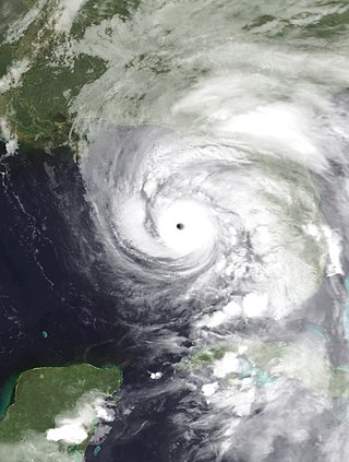
Hurricane Dennis was an early-forming major hurricane in the Caribbean and Gulf of Mexico during the record-breaking 2005 Atlantic hurricane season. Dennis was the fourth named storm, second hurricane, and first major hurricane of the season. Forming in July, the hurricane became the strongest Atlantic hurricane ever to form before August at the time, a title it held for only six days before being surpassed by Hurricane Emily.

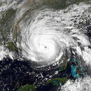
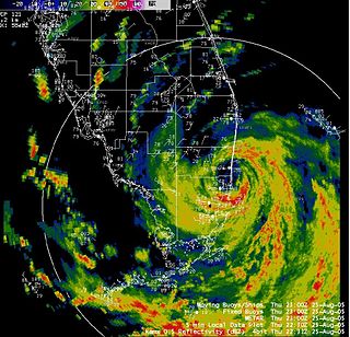
Hurricane Rita was the most intense tropical cyclone on record in the Gulf of Mexico and the fourth-most intense Atlantic hurricane ever recorded. Part of the record-breaking 2005 Atlantic hurricane season, which included three of the top ten most intense Atlantic hurricanes in terms of barometric pressure ever recorded, Rita was the seventeenth named storm, tenth hurricane, and fifth major hurricane of the 2005 season. It was also the earliest-forming 17th named storm in the Atlantic until Tropical Storm Rene in 2020. Rita formed near The Bahamas from a tropical wave on September 18, 2005 that originally developed off the coast of West Africa. It moved westward, and after passing through the Florida Straits, Rita entered an environment of abnormally warm waters. Moving west-northwest, it rapidly intensified to reach peak winds of 180 mph (285 km/h), achieving Category 5 status on September 21. However, it weakened to a Category 3 hurricane before making landfall in Johnson's Bayou, Louisiana, between Sabine Pass, Texas and Holly Beach, Louisiana, with winds of 115 mph (185 km/h). Rapidly weakening over land, Rita degenerated into a large low-pressure area over the lower Mississippi Valley by September 26th.
Tropical Storm Arlene was an unusually large and early-forming tropical storm, being the first of twenty-eight different storms during the 2005 Atlantic hurricane season, which would become the second most active season on record. Tropical Storm Arlene formed near Honduras on June 8 and moved northwards. It crossed western Cuba on June 10 and strengthened to just under hurricane strength before making its final landfall on the Florida Panhandle the next day. The storm weakened as it continued to move north over the United States, becoming extratropical on June 13. Arlene was responsible for two deaths and minor damage.

Tropical Storm Fay was the sixth named storm of the 2002 Atlantic hurricane season; it was a moderate tropical storm which caused flooding in parts of Texas and Northern Mexico. It formed from a trough of low pressure that moved south into the Gulf of Mexico, and became stationary. A low pressure center developed along this trough, and on September 5, a Hurricane Hunter aircraft reported that the system had gained sufficient organization to be classified a tropical depression, 95 miles (153 km) southeast of Galveston. The depression drifted south-southwest while strengthening, reaching its peak strength of 60 miles per hour (97 km/h) on the morning of September 6. The system then made an abrupt turn to the west-northwest, and remained steady in strength and course until landfall the next day, near Matagorda. The system weakened rapidly after landfall degenerating into a remnant low on September 8, but the storm's circulation survived for another three days.

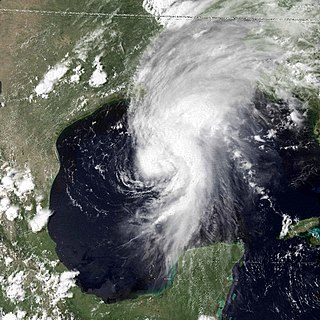
Tropical Storm Hanna was a moderately strong tropical storm that affected the Gulf Coast and Southeastern regions of the United States. The ninth tropical cyclone and eighth named storm of the 2002 Atlantic hurricane season, Hanna formed through the complex interaction of a surface trough, a tropical wave, and an upper-level low pressure system, a disturbance in the upper atmosphere. Designated a tropical depression at 0000 UTC on September 12, the storm remained disorganized throughout its duration, though it attained tropical storm status and a peak intensity of 1,001 mbar (29.6 inHg), with winds of 60 miles per hour (100 km/h). Hanna crossed extreme southeastern Louisiana, and made a second landfall along the Alabama–Mississippi border.
Hurricane Bob was the first Atlantic tropical cyclone to be officially designated using a masculine name after the discontinuation of Joint Army/Navy Phonetic Alphabet names. Bob brought moderate damage to portions of the United States Gulf Coast and areas farther inland in July 1979. The storm was the first hurricane in the Gulf of Mexico to form in the month of July since 1959, and was the fifth tropical cyclone to form during the annual hurricane season. Though the origin of Bob can be traced back to a tropical wave near the western coast of Africa in late June, Bob formed from a tropical depression in the southwestern Gulf of Mexico on July 9. Tracking in a general northward direction, favorable conditions allowed for quick strengthening. Less than a day after formation, the system reached tropical storm intensity, followed by hurricane intensity on July 11. Shortly after strengthening into a hurricane, Bob reached its peak intensity with maximum sustained winds of 75 mph (121 km/h) and a minimum barometric pressure of 986 mbar. At the same intensity, Bob made landfall west of Grand Isle, Louisiana, and rapidly weakened after moving inland. However, the resulting tropical depression persisted for several days as it paralleled the Mississippi and Ohio rivers. On July 16, the system emerged into the western Atlantic, where it was subsequently absorbed by a nearby low-pressure area.

Tropical Storm Barry was a strong tropical storm that made landfall on the Florida Panhandle during August 2001. The third tropical cyclone and second named storm of the 2001 Atlantic hurricane season, Barry developed from a tropical wave that moved off the coast of Africa on July 24. The wave entered the Caribbean on July 29 and spawned a low-pressure area, which organized into Tropical Storm Barry on August 3. After fluctuations in intensity and track, the storm attained peak winds of 70 mph (110 km/h) over the Gulf of Mexico. Barry headed northward and moved ashore along the Gulf Coast before degenerating into a remnant low on August 7. On the next day, Barry's remnants dissipated over Missouri.

Tropical Storm Hermine was the eighth tropical cyclone and named storm of the 1998 Atlantic hurricane season. Hermine developed from a tropical wave that emerged from the west coast of Africa on September 5. The wave moved westward across the Atlantic Ocean, and on entering the northwest Caribbean interacted with other weather systems. The resultant system was declared a tropical depression on September 17 in the central Gulf of Mexico. The storm meandered north slowly, and after being upgraded to a tropical storm made landfall on Louisiana, where it quickly deteriorated into a tropical depression again on September 20.

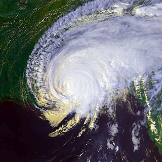
The effects of Hurricane Dennis in Florida included 14 deaths and $1.5 billion in damage. The tropical wave that became Hurricane Dennis formed on June 29, 2005, and proceeded westward across the Atlantic Ocean. It became a tropical depression on July 4, a tropical storm on July 5, and a hurricane on July 7. Dennis rapidly intensified to attain Category 4 status on the Saffir-Simpson Hurricane Scale, and made landfall in Cuba where it weakened to Category 1 status, before re-emerging in the Gulf of Mexico and re–intensifying. The storm made landfall as a Category 3 hurricane on Santa Rosa Island on July 10.
The Effects of Hurricane Dennis in Alabama included $127 million (2005 USD) in damage and three injuries. Dennis made landfall on the Florida Panhandle as a Category 3 hurricane on the Saffir-Simpson scale on July 10, 2005, before tracking over Alabama as a minimal hurricane. In preparation for the storm, about 500,000 people were given evacuation orders, and the Red Cross opened 87 shelters. As a result, all southbound lanes of Interstate 65 from Mobile to Montgomery were closed.
The effects of Hurricane Dennis in Georgia included two deaths and $24 million (2005 USD) in damage. On June 29, 2005, a tropical wave emerged off the west coast of Africa. Gradually, the system organized on July 2 and formed a broad low pressure area. The system continued to organize, and it became a tropical depression on July 4. Tracking westward, it became a tropical storm on July 5 and a hurricane on July 7. Dennis rapidly intensified to attain Category 4 status on the Saffir-Simpson Hurricane Scale before making landfall on Cuba. The storm weakened to Category 1 status before re-emerging in the Gulf of Mexico and intensifying to a Category 4. Dennis weakened before the cyclone made landfall on the Florida Panhandle on July 10, then tracked over southeast Alabama.

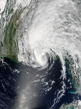
Tropical Storm Edouard brought coastal and minor inland flooding to Louisiana and Texas in August 2008. The fifth tropical cyclone and fifth named storm of the hurricane season, Edouard developed from a trough in the northern Gulf of Mexico on August 3. After developing into a tropical depression, it gradually strengthened and was upgraded to Tropical Storm Edouard on August 4. However, northerly wind shear initially halted any further significant intensification and also caused the storm to struggle to maintain deep convection over the center. Edouard eventually intensified further and peaked as a strong tropical storm with winds of 65 mph (100 km/h) on August 5. Shortly thereafter, the storm made landfall near Gilchrist, Texas later that day. Edouard quickly weakened and was downgraded to tropical depression by early on August 6, six hours before degenerated into a remnant low pressure area.
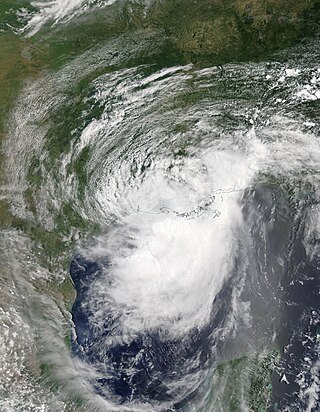
The effects of Hurricane Katrina in Florida were in both the southern portion of the state and in the panhandle. After developing on August 23, Katrina made landfall near the border of Broward and Miami-Dade counties with 80 mph (130 km/h) winds on August 25. While it was crossing the state, the hurricane's convection was asymmetrical, primarily located to the south and east of the center. As a result, high rainfall totals occurred in the Miami area, peaking at 16.43 in (417 mm) in Perrine. The rains caused flooding, and the combination of rains and winds downed trees and power lines, leaving 1.45 million people without power. Damage in South Florida was estimated at $523 million (2005 USD), mostly as a result of crop damage. Further south, the hurricane spawned a tornado in the Florida Keys. In the island chain, Katrina caused heavy rainfall and gusty winds.
The effects of Hurricane Georges in Mississippi included $676.8 million in damages but no fatalities. Hurricane Georges was a Category 2 storm at landfall in Mississippi during the 1998 Hurricane season.
Hurricane Barry was an asymmetrical Category 1 hurricane that was the wettest tropical cyclone on record in Arkansas and the fourth-wettest in Louisiana. The second tropical or subtropical storm and first hurricane of the 2019 Atlantic hurricane season, Barry originated as a mesoscale convective vortex over southwestern Kansas on July 2. The system eventually emerged into the Gulf of Mexico from the Florida Panhandle on July 10, whereupon the National Hurricane Center (NHC) designated it as a potential tropical cyclone. Early on July 11, the system developed into a tropical depression, and strengthened into a tropical storm later that day. Dry air and wind shear caused most of the convection, or thunderstorms, to be displaced south of the center. Nevertheless, Barry gradually intensified. On July 13, Barry attained its peak intensity as Category 1 hurricane with 1-minute sustained winds of 75 mph (120 km/h) and a minimum central pressure of 993 millibars (29.3 inHg). At 15:00 UTC, Barry made its first landfall at Marsh Island, and another landfall in Intracoastal City, Louisiana, both times as a Category 1 hurricane. Barry quickly weakened after landfall, falling to tropical depression status on July 15. The storm finally degenerated into a remnant low over northern Arkansas on the same day, subsequently opening up into a trough on July 16. The storm's remnants persisted for another few days, while continuing its eastward motion, before being absorbed into another frontal storm to the south of Nova Scotia on July 19.

