Coahuila is a state in Northeast Mexico that is divided into 38 municipalities. According to the 2020 Mexican Census, Coahuila is the 15th most populous state with 3,146,771 inhabitants and the third largest by land area spanning 151,846.16 square kilometres (58,628.13 sq mi).

Nueva Rosita is a town in the northeastern part of the state of Coahuila in northern Mexico. It lies about 11 km (7 mi) northwest of the city of Sabinas on Federal Highway 57, and serves as the municipal seat of San Juan de Sabinas municipality.

Playas de Rosarito Municipality is located in the northwestern part of the Mexican state of Baja California comprising part of the Tijuana metropolitan area. It lies just south of the city of Tijuana. Its municipal seat is the city of Rosarito. According to the 2020 census, the municipality had a population of 126,890 inhabitants. Its area is 513.32 km².

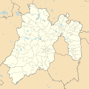
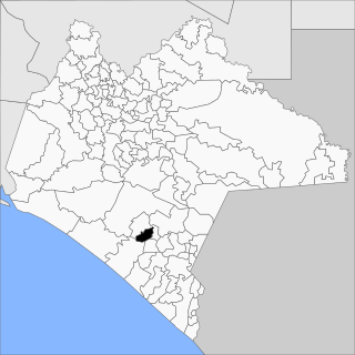
Tequixquiac is a municipality located in the Zumpango Region of the State of Mexico in Mexico. The municipality is located 84 kilometres (52 mi) north of Mexico City within the valley that connects the Valley of Mexico with the Mezquital Valley. The name comes from Nahuatl and means "place of tequesquite waters". The municipal seat is the town of Santiago Tequixquiac, although both the town and municipality are commonly referred to as simply "Tequixquiac".

Huixtán is a town and municipality in the Mexican state of Chiapas in southern Mexico. In the Nahuatl language, Huixtán means "the place of the prickles".
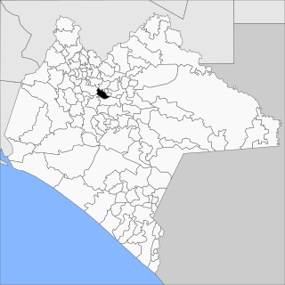
Larráinzar is a municipality in the Mexican state of Chiapas in southern Mexico. The municipal seat is the town of San Andrés Larráinzar.
Maravilla Tenejapa is a town and municipality in the Mexican state of Chiapas in southern Mexico.
Montecristo de Guerrero is a town and municipality in the Mexican state of Chiapas in southern Mexico.

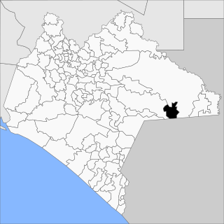
Teopisca is a town and municipality in the Mexican state of Chiapas in southern Mexico.

Tepezalá is a municipality and town in the Mexican state of Aguascalientes. The town of Tepezalá serves as the municipal seat for the surrounding municipality of Tepezalá.

Cutzamala de Pinzón is one of the 81 municipalities of Guerrero, in south-western Mexico. The municipal seat lies at Cutzamala de Pinzón. The municipality covers an area of 611.1 km2.

Ajacuba is a town and one of the 84 municipalities of Hidalgo, in central Mexico. The municipality covers an area of 192.7 km².

Atotonilco de Tula is one of the 84 municipalities of Hidalgo. It is located in the central-southeastern part of the state of Hidalgo in Mexico. The municipal seat is Atotonilco de Tula. The municipality is located at a southern pass leading out of the Mezquital Valley to 86 kilometers north of Mexico City and about 180 km northeast of the state capital of Pachuca de Soto. The name comes from Nahuatl and means "place of hot springs" and otomi language is Padehe. The municipality covers an area of 31 km².

Apaxco is a municipality located in the Zumpango Region in Mexico. The municipal territory is located at a southern pass leading out of the Mezquital Valley about 288 km (179 mi) northeast of the state capital of Toluca. The name Apaxco comes from Nahuatl.

Espita Municipality is one of the 106 subdivisions of the State of Yucatán in Mexico. Its municipal seat is located in the City of Espita and is located on the Litoral Oriente or Region 1 of the state. In 2005, the municipality had the 77th highest HDI in the state with 0.7320, the same as Honduras in 2007.

Santiago Apóstol parish is the Catholic church and parish house of the people of downtown Santiago Tequixquiac, in the Diocese of Cuautitlán in Mexico It is dedicated to Saint James Apostle and includes a sanctuary where the image of Lord of the Chapel is venerated. It is located in the center of town, near Plaza Cuautémoc, by Juárez Avenue. The colonial building in the municipality of Tequixquiac is a monument of great architectural importance, remaining intact to this day.

Tlapanaloya is a town in the municipality of Tequixquiac in Mexico State in Mexico. The town is bordered on the north La Heredad Ranch ranching The Homestead, south to the Tajo de Tequixquiac, east village Hueypoxtla and west by the town of Santiago Tequixquiac. The name Tlapanaloya is a Nahuatl toponymy, means Place where is broken stones, te- is stone, tlapana is to brake, loyan is place.

Hueypoxtla is a municipality situated in the Zumpango Region, which is located in the northeastern part of the state of Mexico in Mexico. The municipality ispositioned at a northern pass that serves as an exit from the Valley of Mexico and Mezquital Valley. The name "Hueypoxtla" originates from Nahuatl and translates to "place of great merchants".

Zumpango is a region, located in the north of the State of Mexico in the country of the same name. It is also known as the Region XVI Zumpango and has seen major population growth. It has a surface area of 8.305 km2 and occupies 12.8% of the state's territory. The seat of Zumpango Region is Zumpango de Ocampo city.
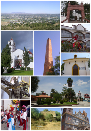
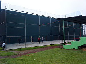
Santiago Tequixquiac or, is a town and municipal seat from municipality of Tequixquiac in the State of Mexico, in Mexico. As of 2010, the village had a total population of 22,676.