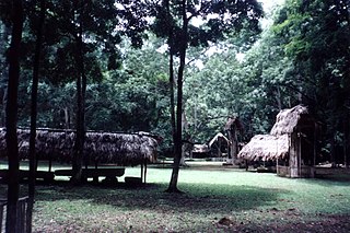
Dos Pilas is a Pre-Columbian site of the Maya civilization located in what is now the department of Petén, Guatemala. It dates to the Late Classic Period, being founded by an offshoot of the dynasty of the great city of Tikal in AD 629 in order to control trade routes in the Petexbatún region, particularly the Pasión River. In AD 648 Dos Pilas broke away from Tikal and became a vassal state of Calakmul, although the first two kings of Dos Pilas continued to use the same emblem glyph that Tikal did. It was a predator state from the beginning, conquering Itzan, Arroyo de Piedra and Tamarindito. Dos Pilas and a nearby city, Aguateca, eventually became the twin capitals of a single ruling dynasty. The kingdom as a whole has been named as the Petexbatun Kingdom, after Lake Petexbatún, a body of water draining into the Pasión River.
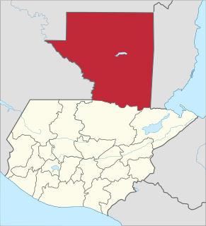
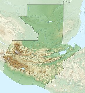
Petén is a department of the Republic of Guatemala. It is geographically the northernmost department of Guatemala, as well as the largest by area — at 13,843 sq mi (35,854 km2) it accounts for about one third of Guatemala's area. The capital is Flores. The population at the 2002 Census was 366,735; the latest official estimate as of mid-2012 was 662,779.

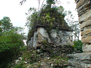
Piedras Negras is the modern name for a ruined city of the pre-Columbian Maya civilization located on the north bank of the Usumacinta River in the Petén department of northeastern Guatemala. Piedras Negras is one of the most powerful of the Usumacinta ancient Maya urban centers. Occupation at Piedras Negras is known from the Late Preclassic period onward, based on dates retrieved from epigraphic information found on multiple stelae and altars at the site. Piedras Negras is an archaeological site known for its large sculptural output when compared to other ancient Maya sites. The wealth of sculpture, in conjunction with the precise chronological information associated with the lives of elites of Piedras Negras, has allowed archaeologists to reconstruct the political history of the Piedras Negras polity and its geopolitical footprint.

Yaxchilan is an ancient Maya city located on the bank of the Usumacinta River in the state of Chiapas, Mexico. In the Late Classic Period Yaxchilan was one of the most powerful Maya states along the course of the Usumacinta River, with Piedras Negras as its major rival. Architectural styles in subordinate sites in the Usumacinta region demonstrate clear differences that mark a clear boundary between the two kingdoms.
Piedras Negras may refer to:

The Usumacinta River is a river in southeastern Mexico and northwestern Guatemala. It is formed by the junction of the Pasión River, which arises in the Sierra de Santa Cruz and the Salinas River, also known as the Chixoy, or the Negro, which descends from the Sierra Madre de Guatemala. It defines part of the border between Guatemala and the Mexican state of Chiapas, then continues its northwesterly course, meandering through the Mexican state of Tabasco to the Gulf of Mexico.
The Petén Basin is a geographical subregion of Mesoamerica, primarily located in northern Guatemala within the Department of El Petén, and into Campeche state in southeastern Mexico.

Pajaral, otherwise known as El Pajaral, is the modern name for a mid-sized ruined city of the pre-Columbian Maya archaeological site located to the south of the San Pedro Martir river in the Petén department of Guatemala. The name El Pajaral was coined by archaeologist Ian Graham, who discovered the site in the 1970s, and refers to the numerous birds he encountered there during his survey.
Xultún is a large Maya archaeological site located 40 km northeast of Tikal and 8 km south of the smaller Preclassic site of San Bartolo in northern Guatemala.
La Amelia is a Pre-Columbian Maya archaeological site near Itzan, in the lower Pasión River region of the Petén Department of Guatemala. It formed a polity in the Late Classic, and was involved in the war between Tikal and Calakmul followed, in 650, by La Amelia's takeover by Dos Pilas. Two centuries of intermittent warfare followed until the area's population was so diminished by about 830, that this is considered the beginning of abandonment of Classic sites in the region.

Altar de Sacrificios is a ceremonial center and archaeological site of the pre-Columbian Maya civilization, situated near the confluence of the Pasión and Salinas Rivers, in the present-day department of Petén, Guatemala. Along with Seibal and Dos Pilas, Altar de Sacrificios is one of the better-known and most intensively-excavated sites in the region, although the site itself does not seem to have been a major political force in the Late Classic period.
The Sierra del Lacandón is a low karstic mountain range in Guatemala and Mexico. It is situated in the north-west of the department of El Petén and the south-east of Chiapas. Its highest points are located near the Mexican border at coordinates 17.244195°N 91.202145°W and 17.195087°N 91.086102°W The range consists of southeast to northwest trending ridges of folded cretaceous limestone and dolomite hills rising above the lowlands of the Petén Basin.
Bejucal is a Maya archaeological site in the Petén Department of Guatemala. It is located 7 kilometres (4.3 mi) northeast of El Zotz and was subservient to that city. The site is thought to date to the second half of the 4th century AD, in the Early Classic period.
Itzan is a Maya archaeological site located in the municipality of La Libertad in the Petén Department of Guatemala. Various small structures at the site were destroyed in the 1980s during oil exploration activities by Sonpetrol and Basic Resources Ltd, prompting rescue excavations by archaeologists. In spite of its small size, the site appears to have been the most politically important centre in its area, as evidenced by its unusually large quantity of monuments and the size of its major architecture.

Itzam Kʼan Ahk II, also known as Ruler 4, was an ajaw of Piedras Negras, an ancient Maya settlement in Guatemala. He ruled during the Late Classic Period, from 729–757 AD. Itzam Kʼan Ahk II ascended to the throne following the death of Kʼinich Yoʼnal Ahk II. Itzam Kʼan Ahk II may have fathered the following three kings of Piedras Negras: Yoʼnal Ahk III, Haʼ Kʼin Xook, and Kʼinich Yat Ahk II. Following Itzam Kʼan Ahk II's demise, he was succeeded by Yoʼnal Ahk III in 757 AD. Itzam Kʼan Ahk II left behind several monuments, including stelae at Piedras Negras and a large mortuary temple now known as Pyramid O-13. In addition, the details of his life and his Kʼatun-jubilee were commemorated on Panel 3, raised by Kʼinich Yat Ahk II several years following Itzam Kʼan Ahk II's death.

Yoʼnal Ahk III, also known as Ruler 5, was an ajaw of Piedras Negras, an ancient Maya settlement in Guatemala. He ruled during the Late Classic Period, from 758 to 767 AD. Yoʼnal Ahk III ascended to the throne upon the death of Itzam Kʼan Ahk II, who may have been Yoʼnal Ahk's father. He was succeeded by his probable brother, Haʼ Kʼin Xook in around 767 AD. Yoʼnal Ahk III left behind two surviving stelae at Piedras Negras, namely Stelae 14 and 16, the former of which has been called one of the finest niche stelae, according to Simon Martin and Nikolai Grube.
Plan de Ayutla is an archaeological site of the pre-Columbian Maya civilization. It is located in the municipality of Ocosingo of the Mexican state of Chiapas. The ruins are notable for having the earliest urban remains in the Upper Usumacinta region, as well as a unique ancient theater for elite use. The ancient identity of the site is subject to debate.
Haʼ Kʼin Xook, also known as Ruler 6, was an ajaw of Piedras Negras, an ancient Maya settlement in Guatemala. He ruled during the Late Classic Period, from 767–780 AD. Haʼ Kʼin Xook was a son of Itzam Kʼan Ahk II, and he ascended the throne following the death of his brother, Yoʼnal Ahk III. Haʼ Kʼin Xook's reign ended with either his death or his abdication in favor of his brother Kʼinich Yat Ahk II; archaeologists and Mayanists have not arrived at a clear consensus. Haʼ Kʼin Xook left behind several monuments, including stelae at Piedras Negras and a stone fragment from El Porvenir. In addition, a stone seat known as Throne 1 and erected by Kʼinich Yat Ahk II records either the death or abdication of Haʼ Kʼin Xook.

Kʼinich Yat Ahk II, also known as Ruler 7, was the last ajaw of Piedras Negras, an ancient Maya settlement in Guatemala. He ruled during the Late Classic Period, from 781 to roughly 808 AD. Possibly a descendant of Itzam Kʼan Ahk II, Kʼinich Yat Ahk II ascended the throne upon the death of his brother, the sixth ajaw of the site, Haʼ Kʼin Xook. While Kʼinich Yat Ahk II presided over the destruction of the rival Maya site Pomona, his reign likely ended with Kʼinich Tatbu Skull IV of Yaxchilan capturing and subjugating Piedras Negras. Itzam Kʼan Ahk II left behind several monuments, including stelae at Piedras Negras, a stone seat known as Throne 1 which records either the death or abdication of Haʼ Kʼin Xook, and Panel 3 which recounts the exploits of Itzam Kʼan Ahk II.

La Mar, also known by its Maya name Rabbit Stone, is the modern name for a ruined city of the pre-Columbian Maya civilization located in the state of Chiapas in Mexico. During the 8th century AD, it was an ally of the nearby center Piedras Negras. Stela 12 at Piedras Negras, identifies one of the kings of La Mar as being named Parrot Chaak.