Mintilogli or Midilogli is a village and a community in the municipal unit of Paralia in the municipality of Patras in Achaea, Greece. It is 1 km south of Paralia, and 8 km southwest of Patras city centre. Ovrya is to the east. The community consists of the villages Mintilogli (seat) and Chantziliako. Its population is around 2,000. The Greek National Road 9 passes the village on the north and west.

Vrachnaiika is a town and a former municipality in Achaea, West Greece, Greece. Since the 2011 local government reform it is part of the municipality Patras, of which it is a municipal unit. The municipal unit has an area of 32.111 km2. It is suburb of a Patras, about 11 km southwest of the city centre, on the Gulf of Patras coast. The population of the town is around 2,700 and of the municipal unit around 4,600. The community has a disused rail station on the line from Patras to Pyrgos. The Greek National Road 9 passes south of the centre.
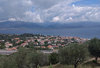
Saravali is a village and a community in the municipal unit of Messatida, Achaea, Greece. The community is located at the southeastern edge of the agglomeration of Patras. The community consists of the villages Saravali, Agios Stefanos, Demenika, Kefalovryso and Bakari. Saravali is 6 km south of Patras city centre. Adjacent communities are Petroto to the east, Patras to the north, Ovrya to the west and Krini to the south. The Greek National Road 9 runs through the community.
Sageika is a village and a community in the municipal unit of Movri, western Achaea, Greece. The population of the village is about 1000. It is located in the plains between the Movri hills and the Gulf of Patras. It is 3 km west of Kareika, 6 km east of Metochi, 9 km southwest of Kato Achaia and 28 km southwest of Patras. The Greek National Road 9 runs through the village.
Alissos is a village and a community in the municipal unit of Dymi, Achaea, Greece. It is located near the Gulf of Patras, 3 km east of Kato Achaia, 3 km southwest of Kaminia and 17 km southwest of Patras. The community consists of the villages Alissos, Kamenitsa, Paralia Alissou and Profitis Elissaios. The Greek National Road 9 and the railway from Patras to Pyrgos run between Alissos and Paralia Alissou.
Niforeika is a village and a community in the municipality of West Achaea in northwestern Achaea, Greece. It is located near the Gulf of Patras, 4 km east of Limnochori, 3 km west of Kato Achaia and 22 km southwest of Patras. The distance from the Greek National Road 9 is about 4 km. The community consists of the villages Niforeika and Paralia Niforeikon.
Lakkopetra is a village and a community in the northeastern part of the municipal unit of Larissos, northwestern Achaea, Greece. The community consists of the villages Lakkopetra, Ioniki Akti, Karnari and Limanaki. It is located on the Gulf of Patras, 4 km east of Araxos, 4 km northwest of Limnochori, 9 km west of Kato Achaia and 26 km southwest of Patras. It is 3 km northeast of the Araxos Airport. Ioniki Akti is a known beach resort.
Kallithea is a community in the suburbs of Patras in Achaea, Greece. It is located 9 km south of downtown Patras, on the Greek National Road 33 to Tripoli. The community consists of the villages Kallithea and Ano Kallithea, and is part of the municipal unit Messatida within the municipality of Patras. The nearest villages are Ovrya to the north and Thea to the west. To the east lies the mountain Omplos.
Metochi is a village and a community in the municipal unit of Larissos, western Achaea, Greece. The community consists of the villages Metochi, Vouprasio, Neo Vouprasio and Lappas. Lappas was the seat of the former municipality of Larissos. Metochi is located in the plains near the Ionian Sea coast, 5 km south of Araxos, 3 km southwest of Araxos Airport, 14 km west of Kato Achaia and 32 km west of Patras. The Prokopos lagoon, which is fed by the river Larissos, is 1 km north of Metochi. Lappas is on the Greek National Road 9 and on the railway from Patras to Pyrgos.
Tsoukalaiika is a village and a community in the municipal unit of Vrachnaiika in the northern part of Achaea, Greece. It is on the southwestern edge of the metropolitan area of Patras, on the Gulf of Patras, 13 km southwest of Patras city centre. It is located on the Greek National Road 9 and the railway from Patras to Pyrgos.
Arachovitika is a village and a community in the municipal unit of Rio in the northern part of Achaea, Greece. It is situated on the Gulf of Corinth, 1 km northwest of Drepano and 6 km northeast of Rio. The Greek National Road 8A passes south of the village, and the railway Patras - Corinth runs through the village. The community consists of the villages Arachovitika and Kato Arachovitika. There is a port next to Cape Drepano.
Psathopyrgos is a tourist village and community in the municipal unit of Rio in the northern part of Achaea, Greece. Psathopyrgos is located on the Gulf of Corinth, south east of Cape Drepano, the northernmost point of the Peloponnese peninsula. The village has a small pebble beach and it is known to the locals and tourists for its fish taverns and nice views of the green mountains south of the village.
Kareika is a village and a community in the municipal unit of Movri, Achaea, Greece. The community consists of the villages Kareika, Gomosto, Karamesineika and Rachi. It is located north of the Movri hills, 3 km east of Sageika, 6 km southwest of Kato Achaia and 25 km southwest of Patras. The Greek National Road 9/E55 passes through the community.
Petroto is a village and a community in the municipal unit of Messatida, Achaea, Greece. The community consists of the villages Petroto, Mavromandila and Agia Paraskevi. Mavromandila is by far the largest village of the community, and is also referred to as Petroto. Mavromandila is located 6 km southeast of Patras city centre, just outside the Patras beltway. The small mountain villages Petroto and Agia Paraskevi are located resp. 5 and 9 km southeast from Mavromandila, to the east and southeast of Omplos mountain. The renowned Achaia Clauss winery is situated in Mavromandila.

Kato Achaia is a town and a community in Achaea, West Greece, Greece. Since the 2011 local government reform it is part of the municipality West Achaea, of which it is the seat of administration. The community Kato Achaia consists of the town Kato Achaia and the villages Alykes, Manetaiikia, Paralia Kato Achaias and Piso Sykea. Nearby are the ruins of the ancient city of Dyme.
Platanos is a village and a community in the municipal unit of Akrata, Achaea, Greece. In 2011 Platanos had a population of 231 for the village, and 259 for the community, which includes the mountain villages Ano Potamia, Korinthiako Balkoni and Tsivlos. The village Platanos consists of two parts: the seaside settlement Paralia Platanou on the Gulf of Corinth and Platanos proper at about 250 m elevation on a mountain slope directly above Paralia Platanou. The villages Ano Potamia and Tsivlos are about 10 km south of Platanos. Platanos is 5 km west of Akrata and 18 km southeast of Aigio. The Greek National Road 8A and the railway Corinth - Patras pass north of Platanos.
Petrochori is a village in Achaea, Greece. It is part of the municipality of West Achaea. It is located 6 km south of Kato Achaia, and 25 km southeast of Patras. The population of Petrochori in 2001 was 177 for the village and 721 for the community, which consists of the villages Petrochori, Karya, Lampraiika, Logothetis, Veskoukaiika, Vythoulkas and Zampeteika. The nearest villages are Ano Achaia to the northeast and Elaiochori to the east.
Agiovlasitika is a village in Achaea, Greece. Agiovlasitika is in the municipality of West Achaea. It is located about 3 km southeast of Kato Achaia, and 20 km southwest of Patras. The river Peiros flows northeast of the village. Its population in 2011 was 84 for the village and 241 for the community, which consists of the villages Agiovlasitika, Kapeli, Lefkos and Stenaitika.
Stavrodromi is a village and a community in Achaea, Greece. The community consists of the villages Stavrodromi, Panousaiika, Rachi and Xirochori. It is located in a hilly area northwest of Mount Erymanthos, 35 km (22 mi) south of Patras. The Greek National Road 33 runs through the village. In 2011 Stavrodromi had a population of 153 for the village and 278 for the community. Stavrodromi was the seat of the municipality of Tritaia.
Psofida is a village and a community in the municipal unit of Aroania in the southern part of Achaea, Greece. The community consists of the villages Psofida, Ano Psofida, Tripotama, Ano Tripotama, Kato Tripotama and Vasiliki. Psofida was named after the ancient Arcadian town Psophis, that was located near the present village Tripotama. It is situated near the confluence of the rivers Erymanthos, Aroanios and Seiraios, and near the tripoint of Achaea, Arcadia and Elis. It is 4 km southwest of Livartzi, 9 km east of Lampeia, 25 km southwest of Kalavryta and 45 km southeast of Patras. The Greek National Road 33 passes through Tripotama.