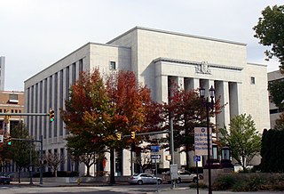
Dauphin County is a county in the Commonwealth of Pennsylvania. As of the 2020 census, the population was 286,401. The county seat is Harrisburg, Pennsylvania's state capital and ninth-most populous city. The county was created on March 4, 1785, from part of Lancaster County and was named after Louis Joseph, Dauphin of France, the first son of King Louis XVI.

Dauphin is a borough in Dauphin County, Pennsylvania, United States. The population was 796 at the 2020 census. Dauphin's ZIP code is 17018. It is part of the Harrisburg–Carlisle Metropolitan Statistical Area.

Highspire is a borough in Dauphin County, Pennsylvania, United States. The population was 2,741 at the 2020 census, an increase over the figure of 2,399 tabulated in 2010. It is part of the Harrisburg–Carlisle Metropolitan Statistical Area.

Lower Paxton is a township in Dauphin County, Pennsylvania, United States. The population was 53,501 at the 2020 census. It is the most populous municipality in Dauphin County and the 17th-most populated municipality in the state.

Lower Swatara Township is a township in Dauphin County, Pennsylvania, United States. The population was 9,557 at the 2020 census. Harrisburg International Airport and Penn State Harrisburg are located within the township. It shares a ZIP Code with the nearby borough of Middletown, and all locations in the township have Middletown addresses.
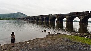
Susquehanna Township is a township in Dauphin County, Pennsylvania, United States. The population was 26,736 at the time of the 2020 census. This represents a 9.8% increase from the 2000 census count of 21,895. Susquehanna Township has the postal ZIP codes 17109 and 17110, which maintain the Harrisburg place name designation. The township is a suburb of Harrisburg and is connected to Marysville by the Rockville Bridge, the world's longest stone-arch rail bridge at the time of its completion.
Swatara Township is a township in Dauphin County, Pennsylvania. The population was 27,824 at the 2020 census.

Washington Township is a township that is located in Dauphin County, Pennsylvania, United States. As of the 2020 census, the township population was 2,127, a decline from the figure of 2,268 that was tabulated in 2010.
Wayne Township is a township that is located in Dauphin County, Pennsylvania, United States. The population was 1,264 at the time of the 2020 census.

Pennsylvania Route 39 (PA 39) is a 17.83-mile-long (28.69 km) state highway located in Dauphin County, Pennsylvania, United States. PA 39 runs from North Front Street near Harrisburg east to U.S. Route 322 (US 322) and US 422 near Hummelstown and Hershey. The route passes through the northern and eastern suburbs of Harrisburg and passes by Hersheypark, Giant Center, as well as the primary production factory for The Hershey Company. Between Harrisburg and Manada Hill, it is known as Linglestown Road, from Manada Hill to Hershey as Hershey Road and from Hershey to near Hummelstown and Hershey as Hersheypark Drive. Prior to the establishment of PA 39 in 1937, PA 39, had previously been designated as a route in northeastern Pennsylvania during the 1920s. That designation was deleted when it was renumbered US 11. As a result, PA 39 is one of a few routes which has a set of child routes which are no where near the primary route.
Conewago Creek is a 23.0-mile-long (37.0 km) tributary of the Susquehanna River in Lebanon, Dauphin, and Lancaster counties in Pennsylvania in the United States. The source is at an elevation of 1,100 feet (340 m) at Mount Gretna Heights in Lebanon County. The mouth is the confluence with the Susquehanna River at an elevation of 261 feet (80 m) at the border of Dauphin and Lancaster counties, just south of Three Mile Island in the river and just north of the unincorporated village of Falmouth in Conoy Township, Lancaster County.
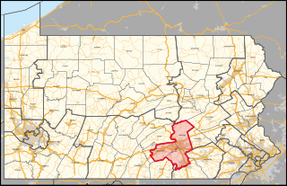
Pennsylvania's 10th congressional district is located in the south-central region of the state. It encompasses all of Dauphin County as well as parts of Cumberland County and York County. The district includes the cities of Harrisburg and York. Prior to 2019, the district was located in the northeastern part of the state. The Supreme Court of Pennsylvania redrew the district in 2018 after ruling the previous map unconstitutional due to gerrymandering. The court added State College to the old district's boundaries while removing some Democratic-leaning areas and redesignated it the twelfth district, and they reassigned the tenth district to an area around Harrisburg and York. The new tenth district is represented by Republican Scott Perry, who previously represented the old fourth district.

Paxton Creek is a 13.9-mile-long (22.4 km) tributary of the Susquehanna River in Dauphin County, Pennsylvania in the United States.
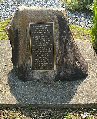
Estherton is an unincorporated area and neighborhood in Susquehanna Township, Dauphin County, Pennsylvania, United States, and a part of the Harrisburg-Carlisle area. It is situated on the Susquehanna River, just north of the city of Harrisburg and above the Montrose Park neighborhood but below the Lucknow neighborhood within Susquehanna Township. Interstate 81 runs through the community to the George N. Wade Memorial Bridge.

Hoernerstown is an unincorporated community in South Hanover Township, Dauphin County, Pennsylvania, United States and is a part of the Harrisburg–Carlisle Metropolitan Statistical Area.
Bachmanville is an unincorporated community in northeastern Conewago Township, Dauphin County, Pennsylvania, United States and is part of the Harrisburg-Carlisle Metropolitan Statistical Area.

Carsonville is an unincorporated community in Jefferson Township, Dauphin County, Pennsylvania, United States and is part of the Harrisburg–Carlisle Metropolitan Statistical Area.
Loyalton is an unincorporated community in Washington Township, Dauphin County, Pennsylvania, United States, and is a part of the Harrisburg-Carlisle Metropolitan Statistical Area. The latitude is 40.569, and the longitude -76.762; its elevation is 577 feet (176 m).

Matamoras is an unincorporated community in Halifax Township, Dauphin County, Pennsylvania, United States, located in the Harrisburg-Carlisle Metropolitan Statistical Area.

Lavelle is a census-designated place that is located in Butler Township, Schuylkill County in the Commonwealth of Pennsylvania, in the United States. Situated on Pennsylvania Route 901, it was part of the Lavelle-Locustdale CDP for the 2000 census, before the communities were split into the two separate CDPs of Lavelle and Locustdale.


