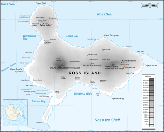
Ross Island is an island formed by four volcanoes in the Ross Sea near the continent of Antarctica, off the coast of Victoria Land in McMurdo Sound. Ross Island lies within the boundary of Ross Dependency, an area of Antarctica claimed by New Zealand.

Mount Erebus is the second-highest volcano in Antarctica, the highest active volcano in Antarctica, and the southernmost active volcano on Earth. It is the sixth-highest ultra mountain on an island, and the second-highest in Antarctica. With a summit elevation of 3,794 metres (12,448 ft), it is located in the Ross Dependency on Ross Island, which is also home to three inactive volcanoes: Mount Terror, Mount Bird, and Mount Terra Nova.

Mount Terror is a large shield volcano that forms the eastern part of Ross Island, Antarctica. It has numerous cinder cones and domes on the flanks of the shield and is mostly under snow and ice. It is the second largest of the four volcanoes that make up Ross Island and is somewhat overshadowed by its neighbour, Mount Erebus, 30 km (19 mi) to the west. Mount Terror was named in 1841 by Sir James Clark Ross for his second ship, HMS Terror. The captain of Terror was Francis Crozier, a close friend of Ross for whom the nearby Cape Crozier is named.

HMS Erebus was a Hecla-class bomb vessel constructed by the Royal Navy in Pembroke dockyard, Wales, in 1826. The vessel was the second in the Royal Navy named after Erebus, the personification of darkness in Greek mythology.

HMS Terror was a specialised warship and a newly developed bomb vessel constructed for the Royal Navy in 1813. She participated in several battles of the War of 1812, including the Battle of Baltimore with the bombardment of Fort McHenry. She was converted into a polar exploration ship two decades later, and participated in George Back's Arctic expedition of 1836–1837, the successful Ross expedition to the Antarctic of 1839 to 1843, and Sir John Franklin's ill-fated attempt to force the Northwest Passage in 1845, during which she was lost with all hands along with HMS Erebus.
Herbert Sound is a sound in Antarctica extending from Cape Lachman and Keltie Head on the northwest to the narrows between The Naze and False Island Point on the southeast, separating Vega Island from James Ross Island and connecting Prince Gustav Channel with Erebus and Terror Gulf. On January 6, 1843, Captain James Clark Ross discovered a broad embayment east of the sound, which he named "Sidney Herbert Bay" after Sidney Herbert, First Secretary to the Admiralty. The sound proper was discovered and charted by the Swedish Antarctic Expedition, 1901–04, under Otto Nordenskiöld, who included it with the broad embayment under the name "Sidney Herbert Sound". The recommended application restricts Herbert Sound to the area west of the narrows between The Naze and False Island Point; the embayment discovered by Ross forms the western margin of Erebus and Terror Gulf.

Sir James Clark Ross was a British Royal Navy officer and polar explorer known for his explorations of the Arctic, participating in two expeditions led by his uncle John Ross, and four led by William Edward Parry, and, in particular, for his own Antarctic expedition from 1839 to 1843.
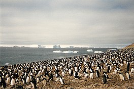
Cape Crozier is the most easterly point of Ross Island in Antarctica. It was discovered in 1841 during James Clark Ross's expedition of 1839 to 1843 with HMS Erebus and HMS Terror, and was named after Francis Crozier, captain of HMS Terror. The extinct volcano Mount Terror, also named during the Ross expedition, rises sharply from the Cape to a height of 3,230 m (10,600 ft), and the edge of the Ross Ice Shelf stretches away to its east.
Ula Point is a low ice-covered point in the Erebus and Terror Gulf, on the northeast coast of James Ross Island, 5 miles (8 km) northwest of Cape Gage. First seen and roughly surveyed by Swedish Antarctic Expedition, 1901–04, under Otto Nordenskjold. It was resurveyed by Falkland Islands Dependencies Survey (FIDS) in 1945. Named by United Kingdom Antarctic Place-Names Committee (UK-APC) for Anton Olsen Ula, boatswain on the Antarctic the ship of the above Swedish expedition.
The Kyle Hills are a prominent group of volcanic cones, hills, ridges, and peaks that occupy the eastern part of Ross Island, Antarctica, between Mount Terror and Cape Crozier. The hills extend east–west for 8 nautical miles (15 km), rising from sea level at Cape Crozier to about 2,600 metres (8,500 ft) in Mount McIntosh at the western end of the group. Local relief of features is on the order of 200 metres (660 ft).
Kienle Nunataks are three aligned nunataks to the north of Mount Terror in northeastern Ross Island, Antarctica. The nunataks trend east–west for 1 nautical mile (2 km) and rise to about 1,700 metres (5,600 ft). The central nunatak is 2.5 nautical miles (5 km) north-northeast of the Mount Terror summit. At the suggestion of P.R. Kyle, they were named by the Advisory Committee on Antarctic Names after Juergen Kienle of the Geophysical Institute, University of Alaska Fairbanks, a United States Antarctic Program team leader for the investigation of volcanic activity and seismicity on Mount Erebus in six field seasons, 1980–81 through 1985–86.

Erebus Glacier is a glacier draining the lower southern slopes of Mount Erebus, Ross Island, Antarctica. It flows west to Erebus Bay where it forms the floating Erebus Glacier Tongue. It was named in association with Mount Erebus by the British National Antarctic Expedition, 1901–04, under Robert Falcon Scott.

Coley Glacier is a glacier, 5 nautical miles (9 km) long, on the east side of James Ross Island. It flows into Erebus and Terror Gulf just north of Cape Gage. It was surveyed by the Falkland Islands Dependencies Survey (FIDS) in 1945 and 1953, and named by the UK Antarctic Place-Names Committee for John A. Coley of FIDS, meteorological assistant at Hope Bay in 1952 and 1953.
Erebus Bay is a bay about 24 kilometres (13 nmi) wide between Cape Evans and Hut Point Peninsula, on the west side of Ross Island. The bay was explored by the British National Antarctic Expedition, 1901–04, under Robert Falcon Scott. It was named by Scott's second expedition, the British Antarctic Expedition, 1910–13, which built its headquarters on Cape Evans; the feature is surmounted by Mount Erebus.
Moore Peak is a peak rising to about 2,500 metres (8,200 ft) on the west slope of Mount Terror, Ross Island, Antarctica. The peak is 1.6 nautical miles (3 km) west-southwest of the summit of Mount Terror and 1 nautical mile (2 km) south of Mount Sutherland. At the suggestion of P.R. Kyle it was named by the Advisory Committee on Antarctic Names in 2000 after James A. Moore, a member of the New Mexico Institute of Mining and Technology team on Mount Erebus in the 1983–84 and 1985–86 field seasons. He completed his Master of Science thesis on the geology of Mount Erebus.
Lonely Rock is a rock rising 7 metres (23 ft) above sea level east of Ula Point, James Ross Island, on the west margin of Erebus and Terror Gulf, Antarctica. It was charted by the Falkland Islands Dependencies Survey, 1945, and named "Lone Rock" by the UK Antarctic Place-Names Committee because of its small size and isolation. The name was modified in 1963 to avoid duplication with Lone Rock off Nelson Island.

Mount Terra Nova is a snow-covered inactive volcanic mountain, 2,130 m (6,990 ft), between Mount Erebus and Mount Terror on Ross Island. It was first mapped by the Discovery expedition in 1901–04, and named for Terra Nova, the relief ship for this expedition and the British Antarctic Expedition, 1910–13.
Lewis Bay is a bay indenting the north coast of Ross Island, Antarctica, between Mount Bird and Cape Tennyson.

The Ross expedition was a voyage of scientific exploration of the Antarctic in 1839 to 1843, led by James Clark Ross, with two unusually strong warships, HMS Erebus and HMS Terror. It explored what is now called the Ross Sea and discovered the Ross Ice Shelf. On the expedition, Ross discovered the Transantarctic Mountains and the volcanoes Mount Erebus and Mount Terror, named after each ship. The young botanist Joseph Dalton Hooker made his name on the expedition.