
Transportation in Philadelphia involves the various modes of transport within the city and its required infrastructure. In addition to facilitating intracity travel, Philadelphia's transportation system connects Philadelphia to towns of its metropolitan area and cities of the Boston-Washington megalopolis.

The 69th Street Transportation Center, also known as the 69th Street Terminal or 69th Street Station, is a SEPTA terminal in the Terminal Square section of Upper Darby, Pennsylvania, just outside the Philadelphia border. It is the other ground-level station on the Market Frankford Line besides Millbourne.
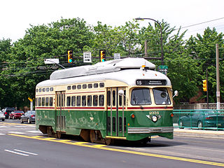
SEPTA's Route 15, the Girard Avenue Line, is a trolley line operated by the Southeastern Pennsylvania Transportation Authority (SEPTA) along Girard Avenue through North and West Philadelphia, Pennsylvania, United States. As of 2007, it is the only surface trolley line in the City Transit Division that is not part of the Subway–Surface Trolley Lines. SEPTA PCC II vehicles are used on the line.

Route 13, also known as the Chester Avenue Line, is a trolley line operated by the Southeastern Pennsylvania Transportation Authority (SEPTA) that connects the 13th Street station in downtown Philadelphia, Pennsylvania, with the Yeadon Loop in Yeadon, Pennsylvania, although limited service is available to the Darby Transportation Center in Darby, Pennsylvania. It is one of five lines that are part of the Subway-Surface Trolley system.

The Olney Transportation Center, also called Olney Terminal, is a SEPTA bus and subway station in Philadelphia, Pennsylvania. It is located at the intersection of Broad Street and Olney Avenue in the Logan neighborhood of North Philadelphia. It is a major bus terminal as well as the last subway stop on the Broad Street Line before the Fern Rock Transportation Center terminus.
Delaware Route 2 (DE 2) is a 10.94-mile-long (17.61 km) east–west highway located in northern New Castle County, Delaware. It runs from DE 72 and DE 273 on the eastern edge of Newark east to DE 52 in Wilmington. DE 2 is known variously as Capitol Trail, Kirkwood Highway, Wilmington Avenue, and Lincoln and Union Streets along its route. Between Newark and Wilmington, the route is a four- to six-lane divided highway that passes through suburban areas. In Wilmington, DE 2 is routed along a one-way pair of city streets.

Pennsylvania Route 3 is a 24.3-mile (39.1 km) state highway located in the southeastern portion of Pennsylvania. The route connects U.S. Route 322 Business in West Chester with PA 611 in Philadelphia. The route begins in downtown West Chester and heads east out of town as a one-way pair of streets. Between West Chester and Upper Darby Township, PA 3 follows a four-lane divided highway known as West Chester Pike through suburban areas. Along this stretch, the route passes through Edgmont, Newtown Square, Broomall, and Havertown. The route has an interchange with Interstate 476 (I-476) between Broomall and Havertown. Upon reaching Upper Darby, PA 3 heads into Philadelphia along Market Street. In Philadelphia, the route follows multiple one-way pairs, running along Chestnut Street and Walnut Street in West Philadelphia before heading into Center City Philadelphia along Market Street and John F. Kennedy Boulevard and ending at Philadelphia City Hall.

State Route 502 is an east–west state highway in western Ohio, a U.S. state. The western terminus of the highway is at the Indiana state line approximately six miles (9.7 km) south of Union City, with the road continuing into the Hoosier State being locally maintained Greenville Pike. The eastern terminus of the highway is in downtown Greenville at a traffic circle where it meets a conglomeration of four other state highways: SR 49, 118, 121 and 571.
The Flatbush Avenue Line is a public transit line in Brooklyn, New York City, United States, running along Flatbush Avenue between Downtown Brooklyn and Marine Park. Originally a streetcar line, it is now the B41 bus route, operated by the New York City Transit Authority.

U.S. Route 13 is a U.S. highway running from Fayetteville, North Carolina north to Morrisville, Pennsylvania. The route runs for 49.33 mi (79.39 km) through the Philadelphia metropolitan area in the U.S. state of Pennsylvania. The route enters the state from Delaware in Marcus Hook, Delaware County. It continues in a northeasterly direction through Delaware County, passing through the city of Chester before heading through suburban areas along Chester Pike to Darby. US 13 enters Philadelphia on Baltimore Avenue and runs through West Philadelphia to University City, where it turns north along several city streets before heading east across the Schuylkill River along Girard Avenue. The route turns north and heads to North Philadelphia, where it runs northeast along Hunting Park Avenue. US 13 becomes concurrent with US 1 on Roosevelt Boulevard, continuing into Northeast Philadelphia. US 13 splits southeast on one-way streets before heading northeast out of the city on Frankford Avenue. The route continues into Bucks County as Bristol Pike, heading northeast to Bristol, where it turns into a divided highway. US 13 becomes a freeway in Tullytown and continues north to its terminus at US 1 near Morrisville. US 13 roughly parallels Interstate 95 (I-95) through its course in Pennsylvania.
Several special routes of U.S. Route 1 exist, from Florida to Maine. In order from south to north, separated by type, these special routes are as follows.

SEPTA's Trolley Route 60, the Allegheny Avenue Line is a former streetcar line and current bus route, operated by the Southeastern Pennsylvania Transportation Authority (SEPTA) in Northwest and Northeast Philadelphia, Pennsylvania, United States. It connects to the East Falls to the Port Richmond, and runs primarily along Allegheny Avenue.

SEPTA's Trolley Route 56, the Erie and Torresdale Avenues Line is a former streetcar line that is now served by bus. It is operated by the Southeastern Pennsylvania Transportation Authority (SEPTA) in Philadelphia, Pennsylvania, United States. The line runs between the Tioga and Tacony neighborhoods primarily along Erie Avenue and Torresdale Avenue. Route 56 was one of three "suspended" by the SEPTA board effective June 12, 1992. The two others, Routes 15 and 23, were then also operated by buses as of the same year; however, the Route 15 Trolley has since been restored back to trolley as of September 5, 2005.
Several special routes of U.S. Route 20 exist. In order from west to east they are as follows.
There are five business routes of Interstate 8.
At least four special routes of U.S. Route 422 currently exist and at least three have been decommissioned.
Cheltenham Avenue is a major east-west road in Southeastern Pennsylvania. It is served by many SEPTA bus routes, trolleys, regional rail, and subway. Cheltenham Avenue is designated quadrant route 2035 in its western section. It also is a major borderline; it defines the border between Springfield and Cheltenham townships, and Cheltenham Township and the City of Philadelphia, with the latter also being the Montgomery County and Philadelphia County. A section of the road along the Philadelphia–Cheltenham border is part of Pennsylvania Route 309.
At least 13 special routes of U.S. Route 84 have existed.


