Related Research Articles

Salem is the capital of the U.S. state of Oregon, and the county seat of Marion County. It is located in the center of the Willamette Valley alongside the Willamette River, which runs north through the city. The river forms the boundary between Marion and Polk counties, and the city neighborhood of West Salem is in Polk County. Salem was founded in 1842, became the capital of the Oregon Territory in 1851, and was incorporated in 1857.

Union County is a county located in the U.S. state of North Carolina. As of the 2020 census, the population was 238,267. Its county seat is Monroe. Union County is included in the Charlotte-Concord-Gastonia, NC-SC Metropolitan Statistical Area.

Forsyth County is located in the northwest Piedmont of the U.S. state of North Carolina. As of the 2020 census, the population was 382,590, making it the fourth-most populous county in North Carolina. Its county seat is Winston-Salem. Forsyth County is part of the Winston-Salem, NC, Metropolitan Statistical Area, which is also included in the Greensboro-Winston-Salem-High Point, NC, Combined Statistical Area. Portions of Forsyth County are in the Yadkin Valley wine region.

Dare County is the easternmost county in the U.S. state of North Carolina. As of the 2020 Census, the population was 36,915. Its county seat is Manteo. Dare County is named after Virginia Dare, the first child born in the Americas to English parents, who was born within the county's current borders. Founded in 1870 from parts of Tyrrell, Currituck and Hyde counties, it consists of a large segment of the Outer Banks of North Carolina, along with a peninsula of land attached to the mainland. Most of the county consists of a string of resort communities along the Outer Banks. While lightly populated by year-round residents, the population swells during the summer with vacationers.
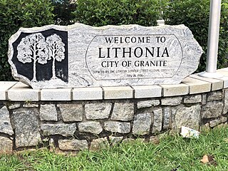
Lithonia is a city in eastern DeKalb County, Georgia, United States. The city's population was 2,662 at the 2020 census. Lithonia is in the Atlanta metropolitan area.

Hanover Park is a village in Cook and DuPage counties in the U.S. state of Illinois, a suburb of Chicago. The population was 37,470 at the 2020 census. Ontarioville is a neighborhood within the village.
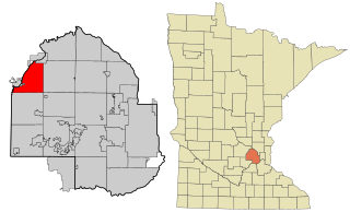
Greenfield is a city in northwestern Hennepin County, Minnesota, United States centered around farming. It has a population of 2,777 residents, according to the 2010 census, and is located 26.5 miles northwest of Minneapolis. It is part of the Twin Cities Metropolitan Statistical Area.

Salem is a town in Rockingham County, New Hampshire, United States. The population was 30,089 at the 2020 census. Being located on Interstate 93 as the first town in New Hampshire, which lacks any state sales tax, Salem has grown into a commercial hub, anchored by the Mall at Rockingham Park. Other major sites include Canobie Lake Park, a large amusement park; and America's Stonehenge, a stone structure of disputed origins. It is the former home of Rockingham Park, a horse racetrack. The Sununu political family hails from Salem, including former New Hampshire governor and White House Chief of Staff John H. Sununu, and his sons John E. Sununu, a former U.S. senator, and Chris Sununu, current New Hampshire governor.

Lewisboro is a town in Westchester County, New York, United States. The population was 12,411 at the 2010 census. The town is named after John Lewis, an early settler. Lewisboro is a suburb of New York City.

Clemmons is a village in Forsyth County, North Carolina, United States and a suburb of Winston-Salem. The population was 18,627 at the 2010 census, with an estimated population of 20,867 in 2019.

Winston-Salem is a city and the county seat of Forsyth County, North Carolina, United States. In 2020, the population was 249,545, making it the second-largest municipality in the Piedmont Triad region, the fifth-most populous city in North Carolina, the third-largest urban area in North Carolina, and the 90th most populous city in the United States. With a metropolitan population of 679,948 it is the fourth largest metropolitan area in North Carolina. Winston-Salem is home to the tallest office building in the region, 100 North Main Street, formerly known as the Wachovia Building and now known locally as the Wells Fargo Center.
Lower Salem is a village in Washington County, Ohio, United States. The population was 86 at the 2010 census. The village is home to a number of local businesses as well as a bank attached to the post office and a volunteer fire department next to the Salem Township Cemetery. Salem-Liberty Elementary School sits north of State Route 821 opposite the East Fork of Duck Creek west of the town's corporation limit and serves as the elementary school for more than 100 students of the Fort Frye Local School District. The municipal building, adjacent to the Bob Hausser Community Park, served as an outpost of the Washington County Sheriff's Office during the early 2000s. A number of unincorporated villages share Lower Salem's post office. These include Warner, Dalzell, Bonn, Harriettsville, and Germantown. The area is home to a number of churches. The only one within city limits, however, is the Lower Salem United Methodist Church. Until a deal was struck with the town council in 2015, meetings of the Salem-Liberty Homemakers/Lower Salem Boys 4-H Club were held in the church's basement. This group is the result of the consolidation of a club made up predominantly of members of Salem-Liberty's FHA (FCCLA) Organization when it served as a high school and the Lower Salem Boys Club which was established in 1920 and is the oldest operational 4-H club in the state of Ohio. Lower Salem was once home to a hotel, a doctor's office, an armory, Wagner's General Store, and a gas station and auto parts shop. While all of these buildings remain standing, all have gone out of business. The general store has been home to a number of startup businesses, but none have survived much longer than a year.

Eola is an unincorporated community in Polk County, Oregon, United States four miles west of Salem on Oregon Route 22 at the confluence of Rickreall Creek and the Willamette River.
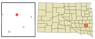
Salem is a city in and the county seat of McCook County, South Dakota, United States. The population was 1,325 at the 2020 census. The current mayor is Shawn English.

Swampscott is a town in Essex County, Massachusetts, United States, located 15 miles (24 km) up the coast from Boston in an area known as the North Shore. The population was 15,111 as of the 2020 United States Census. A former summer resort on Massachusetts Bay, Swampscott is today a fairly affluent residential community and includes the village of Beach Bluff, as well as part of the neighborhood of Clifton.
Viera is an affluent, master-planned community located in the central coastal region of Brevard County, Florida. It is part of an unincorporated section adjacent to the Melbourne, Florida area. For census purposes, it is divided between the Census Designated Places of Viera East and Viera West. At the 2010 census, Viera East had a population of 10,757, while Viera West had a population of 6,641.
Northgate is a neighborhood in Salem, Oregon, United States, located in the far north part of the city. It is one of Salem's larger districts and much of it is industrial rather than residential. Northgate has a neighborhood association, one of the nineteen such groups in Salem.
South Central is a neighborhood in Salem, Oregon, United States, located just south of downtown. Major neighborhood features include Bush's Pasture Park, the Asahel Bush House and Museum, Deepwood Estate, Gaiety Hill-Bush's Pasture Park Historic District, South Salem High School, and Mahonia Hall, the official residence of the governor of Oregon.

The Azalea Park neighborhood is a community within City Heights in the greater San Diego, California area. It is located on top of a plateau 3 miles east of San Diego Bay, with an elevation of around 300 feet. It is bordered to the north by Manzanita Canyon Fairmount Avenue to the east, Interstate 805 to the west, and Hollywood Park to the south.
Northwest Columbus is a region in Franklin County, Ohio. It has about 45,000 residents, according to the 2010 U.S. census.
References
- ↑ "Faye Wright Neighborhood Association".
- ↑ "Faye Wright Population & Demographics, Median Income - Point2". www.point2homes.com. Retrieved 2021-01-18.
- ↑ "area-parks". fayewrightna.org. Archived from the original on 2015-10-22. Retrieved 2015-11-02.
- ↑ "Faye Wright Neighborhood Association".