
Madhya Pradesh is a state in central India. Its capital is Bhopal, and the largest city is Indore, with Gwalior, Jabalpur, Ujjain, Dewas, Sagar, Satna, and Rewa being the other major cities. Madhya Pradesh is the second largest Indian state by area and the fifth largest state by population with over 72 million residents. It borders the states of Uttar Pradesh to the northeast, Chhattisgarh to the east, Maharashtra to the south, Gujarat to the west, and Rajasthan to the northwest.

The West Central Railway, one of the 19 zones of the Indian Railways, came into existence on 1 April 2003. It is headquartered at Jabalpur. It was created by taking away two divisions namely Bhopal division and Jabalpur division from central railways and one division namely Kota division from western railway. The WCR zone provides rail route coverage to the west central region of India. Most of its route is in the states of Madhya Pradesh and Rajasthan with a very little portion in the state of Uttar Pradesh.
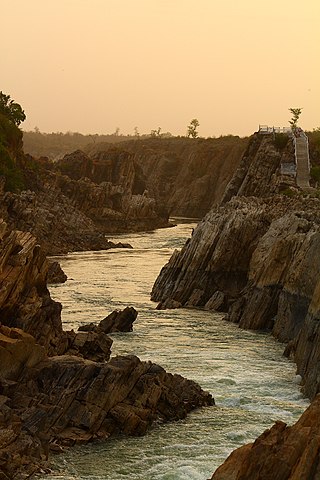
The Narmada River, previously also known as Narbada or anglicised as Nerbudda, is the 5th longest river and overall longest west-flowing river in India. It is also the largest flowing river in the state of Madhya Pradesh. This river flows through the states of Madhya Pradesh and Gujarat in India. It is also known as the "Life Line of Madhya Pradesh and Gujarat" due to its huge contribution to the two states in many ways. The Narmada River rises from the Amarkantak Plateau in Anuppur district Madhya Pradesh. It forms the traditional boundary between North India and South India and flows westwards over a length of 1,312 km (815.2 mi) before draining through the Gulf of Khambhat into the Arabian Sea, 30 km (18.6 mi) west of Bharuch city of Gujarat.

The Satpura Range is a range of hills in central India. The range rises in eastern Gujarat running east through the border of Maharashtra and Madhya Pradesh and ends in Chhattisgarh. The range parallels the Vindhya Range to the north, and these two east–west ranges divide Indian Subcontinent into the Indo-Gangetic plain of northern India and the Deccan Plateau of the south. The Narmada River originates from north-eastern end of Satpura in Amarkantak, and runs in the depression between the Satpura and Vindhya ranges, draining the northern slope of the Satpura range, running west towards the Arabian Sea. The Tapti River originates in the eastern-central part of Satpura, crossing the range in the center and running west at the range's southern slopes before meeting the Arabian Sea at Surat, draining the central and southern slopes of the range. Multai, the place of Tapi river origin is located about 465 kilometer far, south-westerly to Amarkantak, separated across by the hill range. The Godavari River and its tributaries drain the Deccan plateau, which lies south of the range, and the Mahanadi River drains the easternmost portion of the range. The Godavari and Mahanadi rivers flow into the Bay of Bengal. At its eastern end, the Satpura range meets the hills of the Chotanagpur Plateau. The Satpura Range is a horst mountain and is flanked by Narmada Graben in the north and much smaller but parallel Tapi Graben in the south.
Satpura Tiger Reserve (STR) also known as Satpura National Park is located in the Narmadapuram District of Madhya Pradesh in India. Its name is derived from the Satpura range. It covers an area of 524 km2 (202 sq mi). Satpura National Park, along with the adjoining Bori and Pachmarhi wildlife sanctuaries, provides 2,200 km2 (850 sq mi) of unique central Indian highland ecosystem. It was set up in 1981.
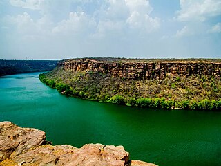
The Chambal River is a tributary of the Yamuna River in Central and Northern India, and thus forms part of the drainage system of the Ganges. The river flows north-northeast through Madhya Pradesh, running for a time through Rajasthan, then forming the boundary between Rajasthan and Madhya Pradesh before turning southeast to join the Yamuna in Uttar Pradesh state.
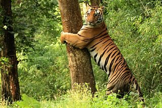
Kanha Tiger Reserve, also known as Kanha–Kisli National Park, is one of the tiger reserves of India and the largest national park of the state of Madhya Pradesh. The present-day Kanha area is divided into two protected areas, Hallon and Banjar, of 250 and 300 km2, respectively. Kanha National Park was created on 1 June 1955 and was designated a tiger reserve in 1973. Today, it encompasses an area of 940 km2 (360 sq mi) in the two districts Mandla and Balaghat.

National Chambal Sanctuary, also called the National Chambal Gharial Wildlife Sanctuary, is a 5,400 km2 (2,100 sq mi) tri-state protected area in northern India for the protection of the Critically Endangered gharial, the red-crowned roof turtle and the Endangered Ganges river dolphin. Located on the Chambal River near the tripoint of Rajasthan, Madhya Pradesh and Uttar Pradesh, it was first declared in Madhya Pradesh in 1978, and now constitutes a long narrow eco-reserve co-administered by the three states. Within the sanctuary, the pristine Chambal River cuts through mazes of ravines and hills with many sandy beaches.

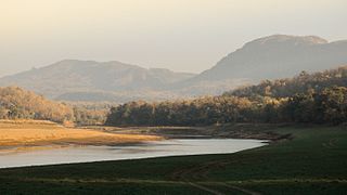
Hoshangabad district, officially Narmadapuram district, is one of the districts of Madhya Pradesh state of India, and Hoshangabad city is the district headquarters.

Panna National Park is an Indian national park in Panna and Chhatarpur Districts of Madhya Pradesh with an area of 542.67 km2 (209.53 sq mi). It was declared in 1994 as the twenty second Tiger reserve of India and the fifth in Madhya Pradesh. Panna National Park was given the Award of Excellence in 2007 as the best maintained national park of India by the Ministry of Tourism of India. Although the reserve went through an ordeal losing almost all of its tigers in 2009 to poaching, a subsequent recovery program touted as one of the most successful big cat population restorations, has resulted in a growth of up to 80 tigers within the park.

The Eastern Highlands moist deciduous forests, presently known as East Deccan moist deciduous forests, is a tropical and subtropical moist broadleaf forests ecoregion in east-central India. The ecoregion covers an area of 341,100 square kilometers (131,700 sq mi), extending across portions of Andhra Pradesh, Chhattisgarh, Jharkhand, Madhya Pradesh, Maharashtra, Odisha, and Telangana states.

The Narmada Valley dry deciduous forests are a tropical dry forest ecoregion of central India. The ecoregion lies mostly in Madhya Pradesh state, but extends into portions of Chhattisgarh, Maharashtra, Karnataka and Uttar Pradesh states.
The Bori Wildlife Sanctuary is a wildlife sanctuary in Hoshangabad District of Madhya Pradesh state in central India.
Kuno National Park is a national park and Wildlife Sanctuary in Madhya Pradesh, India. It derives its name from Kuno River. It was established in 1981 as a wildlife sanctuary with an initial area of 344.686 km2 (133.084 sq mi) in the Sheopur and Morena districts. In 2018, it was given the status of a national park. It is part of the Khathiar-Gir dry deciduous forests ecoregion.
Tourism in Madhya Pradesh has been an attraction of India because of its location in the centre of the country. Madhya Pradesh has won Best Tourism State National award for 3 consecutive years i.e. 2017, 2016 and 2015.

Pench Tiger Reserve or Pench National Park is one of the premier tiger reserves of India and the first one to straddle across two states - Madhya Pradesh and Maharashtra. The reference to Pench is mostly to the tiger reserve in Madhya Pradesh.
Nauradehi Wildlife Sanctuary, covering about 1,197 km2 (462 sq mi), is the largest wildlife sanctuary of Madhya Pradesh state in India. This wildlife sanctuary is a part of 5500 km2 of forested landscape. It is located in the centre of the state covering parts of Sagar, Damoh, Narsinghpur, and Raisen Districts. It is about 90 km from Jabalpur and about 56 km from Sagar.
The Kuno River is a prominent river that flows through the heart of the Kuno National Park from South to north in the Indian state of Madhya Pradesh. The river, which originates from the Vindhya mountain range, is a lifeline for the sanctuary's diverse flora and fauna.
Pench National Park is a national park in India's Madhya Pradesh state, established in 1975 with an area of 257.26 km2 (99.33 sq mi). It includes Pench Tiger Reserve and derives its name from the Pench River that flows through the park from north to south dividing the park into almost equal western and eastern halves, the well-forested areas of Seoni and Chhindwara districts respectively. It was declared a sanctuary in 1965, raised to the status of national park in 1975 and enlisted as a tiger reserve in 1992. In 1983 it was declared as National Park.
Ken Gharial Sanctuary is a wildlife sanctuary in Panna and Chhatarpur Districts of Madhya Pradesh, India. It was established for the conservation of gharial and mugger crocodile populations in 1981.


