
The Rocky Mountains, also known as the Rockies, are a major mountain range in western North America. The Rocky Mountains stretch more than 4,800 kilometers (3,000 mi) from the northernmost part of British Columbia, in western Canada, to New Mexico in the Southwestern United States. Located within the North American Cordillera, the Rockies are somewhat distinct from the Pacific Coast Ranges, Cascade Range, and the Sierra Nevada, which all lie farther to the west.

The Cascade Range or Cascades is a major mountain range of western North America, extending from southern British Columbia through Washington and Oregon to Northern California. It includes both non-volcanic mountains, such as the North Cascades, and the notable volcanoes known as the High Cascades. The small part of the range in British Columbia is referred to as the Canadian Cascades or, locally, as the Cascade Mountains. The latter term is also sometimes used by Washington residents to refer to the Washington section of the Cascades in addition to North Cascades, the more usual U.S. term, as in North Cascades National Park. The highest peak in the range is Mount Rainier in Washington at 14,411 feet (4,392 m).

ThePacific Coast Ranges, are the series of mountain ranges that stretch along the West Coast of North America from Alaska south to Northern and Central Mexico.

The Canadian Rockies or Canadian Rocky Mountains comprise the Canadian segment of the North American Rocky Mountains. They are the eastern part of the Canadian Cordillera, which is a system of multiple ranges of mountains which runs from the Canadian Prairies to the Pacific Coast. The Canadian Rockies mountain system comprises the southeastern part of this system, lying between the Interior Plains of Alberta and Northeastern British Columbia on the east to the Rocky Mountain Trench of BC on the west. The southern end borders Idaho and Montana of the United States. In geographic terms the boundary is at the Canada/US border, but in geological terms it might be considered to be at Marias Pass in northern Montana. The northern end is at the Liard River in northern British Columbia.
The Slate Range is a mountain range of the Canadian Rockies, located in Banff National Park, Canada. The range is named after slate, the primary composition of the mountains in the area.
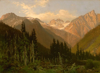
The Selkirk Mountains are a mountain range spanning the northern portion of the Idaho Panhandle, eastern Washington, and southeastern British Columbia which are part of a larger grouping of mountains, the Columbia Mountains. They begin at Mica Peak near Spokane and extend approximately 320 km north from the border to Kinbasket Lake, at the now-inundated location of the onetime fur company post Boat Encampment. The range is bounded on its west, northeast and at its northern extremity by the Columbia River, or the reservoir lakes now filling most of that river's course. From the Columbia's confluence with the Beaver River, they are bounded on their east by the Purcell Trench, which contains the Beaver River, Duncan River, Duncan Lake, Kootenay Lake and the Kootenay River. The Selkirks are distinct from, and geologically older than, the Rocky Mountains. The neighboring Monashee and Purcell Mountains, and sometimes including the Cariboo Mountains to the northwest, are also part of the larger grouping of mountains known as the Columbia Mountains. A scenic highway loop, the International Selkirk Loop, encircles the southern portions of the mountain range.

The Bare Range is a mountain range of the Canadian Rockies, located south of the Red Deer River valley in Banff National Park, Canada. The range is named for the "bareness" of or lack of trees on the gentle slopes of the range.
The Victoria Cross Ranges are a set of mountain ranges in the Canadian Rockies, located to the northwest of Jasper. Of the 19 peaks contained within this range, five are named after Canadian recipients of the Victoria Cross. The area of the ranges is 678 square kilometers.

The Palliser Range is a mountain range of the Canadian Rockies that lies in the extreme southeast corner of Banff National Park.

The Boundary Ranges, also known in the singular and as the Alaska Boundary Range, are the largest and most northerly subrange of the Coast Mountains. They begin at the Nass River, near the southern end of the Alaska Panhandle in the Canadian province of British Columbia and run to the Kelsall River, near the Chilkoot Pass, beyond which are the Alsek Ranges of the Saint Elias Mountains, and northwards into the Yukon Territory flanking the west side of the Yukon River drainage as far as Champagne Pass, north of which being the Yukon Ranges. To their east are the Skeena Mountains and Stikine Plateau of the Interior Mountains complex that lies northwest of the Interior Plateau; the immediately adjoining subregion of the Stikine Plateau is the Tahltan Highland. To their northeast is the Tagish Highland, which is a subregion of the Yukon Plateau. Both highlands are considered in some descriptions as included in the Coast Mountains. The Alexander Archipelago lies offshore and is entirely within Alaska.
The Massive Range is a mountain range of the Canadian Rockies, located in the southwestern area of the Bow River valley in Banff National Park, Canada.

The Vermilion Range is a mountain range of the Canadian Rockies, in Banff National Park, Canada. The range is east of the Sawback Range and west of the Bare and Palliser Ranges.
The Waputik Range lies west of the upper Bow Valley, east of Bath Creek, and south of Balfour Creek in the Canadian Rockies. "Waputik" means "white goat" in Stoney. The range was named by George Mercer Dawson of the Geological Survey of Canada. The President Range lies within the Waputik Range.

The Misty Range is a mountain range of the Canadian Rockies located east of the Bighorn Highway within Kananaskis Country, Canada.

High Rock Range is a mountain range of the Canadian Rockies in southwestern Alberta and southeastern British Columbia, Canada.

Crowsnest Range is a mountain range of the Rocky Mountains in southwestern Alberta and southeastern British Columbia, Canada.

The Mineral Mountains are a group of rugged, volcanic hills and mountains southwest of Superior and northeast of Florence in Pinal County, Arizona.

Mount Crickmer is one of the southernmost summits of the Garibaldi Ranges of the Coast Mountains, overlooking the Central Fraser Valley in the Lower Mainland of British Columbia, Canada. Forming a rocky knoll at the northern end of a relatively flat-topped southeast-northwest axis ridge named Blue Mountain, which divides the basin of Alouette Lake, which lies immediately below it to the west, and the valley of the Stave River; Stave Lake is immediately at its eastern foot. A northerly ridge towards Mount Robie Reid, the next summit northwards, forms a col at Florence and Morgan Lakes low enough to give Crickmer a considerable prominence of 1049m. Beneath that col there is a diversion tunnel feeding the waters of Alouette Lake to the Alouette Powerhouse on Stave Lake.


