
Thurston Island is an ice-covered, glacially dissected island, 215 km (134 mi) long, 90 km (56 mi) wide and 15,700 km2 (6,062 sq mi) in area, lying a short way off the northwest end of Ellsworth Land, Antarctica. It is the third largest island of Antarctica, after Alexander Island and Berkner Island.

Dundee Island is an ice-covered island lying east of the northeastern tip of Antarctic Peninsula and south of Joinville Island.

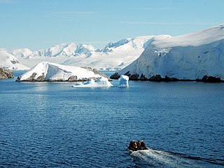
Danco Island or Isla Dedo is an island off Antarctica, 2 kilometres (1 nmi) long lying in the southern part of Errera Channel, off the west coast of Graham Land. It was charted by the Belgian Antarctic Expedition under Adrien de Gerlache, 1897–1899. Danco Island was surveyed by the Falkland Islands Dependencies Survey from Norsel in 1955, and named by the UK Antarctic Place-names Committee for Emile Danco (1869–1898), a Belgian geophysicist and member of the Belgian Antarctic Expedition, who died on board Belgica in the Antarctic.

Denman Glacier is a glacier 7 to 10 nautical miles wide, descending north some 70 nautical miles, which debouches into the Shackleton Ice Shelf east of David Island, Queen Mary Land. It was discovered in November 1912 by the Western Base party of the Australasian Antarctic Expedition under Sir Douglas Mawson. Mawson named the glacier for Lord Denman, Governor-General of Australia in 1911, a patron of the expedition.

The Windmill Islands are an Antarctic group of rocky islands and rocks about 11.1 kilometres (6 nmi) wide, paralleling the coast of Wilkes Land for 31.5 kilometres (17 nmi) immediately north of Vanderford Glacier along the east side of Vincennes Bay. Kirkby Shoal is a small shoal area with depths of less than 18 metres (59 ft) extending about 140 metres (459 ft) westwards and SSW, about 3.4 kilometres (2.1 mi) from the summit of Shirley Island, Windmill Islands, and 0.24 kilometres (0.15 mi) NW of Stonehocker Point, Clark Peninsula.

Snow Hill Island is an almost completely snowcapped island, 33 km (21 mi) long and 12 km (7.5 mi) wide, lying off the east coast of the Antarctic Peninsula. It is separated from James Ross Island to the north-east by Admiralty Sound and from Seymour Island to the north by Picnic Passage. It is one of several islands around the peninsula known as Graham Land, which is closer to South America than any other part of the Antarctic continent.
Gain Glacier is a large glacier on the east coast of Palmer Land, Antarctica, flowing northeast from Cat Ridge and entering the Weddell Sea between Imshaug Peninsula and Morency Island. It was mapped by the United States Geological Survey in 1974, and was named by the Advisory Committee on Antarctic Names for Louis Gain, a naturalist on the French Antarctic Expedition, 1908–10, and the author of several of the expedition reports on zoology and botany.

Posadowsky Glacier is a glacier about 9 nautical miles long, flowing north to Posadowsky Bay immediately east of Gaussberg. Posadowsky Bay is an open embayment, located just east of the West Ice Shelf and fronting on the Davis Sea in Kaiser Wilhelm II Land. Kaiser Wilhelm II Land is the part of East Antarctica lying between Cape Penck, at 87°43'E, and Cape Filchner, at 91°54'E, and is claimed by Australia as part of the Australian Antarctic Territory. Other notable geographic features in this area include Drygalski Island, located 45 mi NNE of Cape Filchner in the Davis Sea, and Mirny Station, a Russian scientific research station.
The Melchior Islands are a group of many low, ice-covered islands lying near the center of Dallmann Bay in the Palmer Archipelago, Antarctica. They were first seen but left unnamed by a German expedition under Eduard Dallmann, 1873–74. The islands were resighted and roughly charted by the Third French Antarctic Expedition under Jean-Baptiste Charcot, 1903–05. Charcot named what he believed to be the large easternmost island in the group "Île Melchior" after Vice Admiral Jules Melchior of the French Navy, but later surveys proved Charcot's Île Melchior to be two islands, now called Eta Island and Omega Island. The name Melchior Islands has since become established for the whole island group now described, of which Eta Island and Omega Island form the eastern part, while the Sigma Islands mark the northern limit of the islands. The group was roughly surveyed in 1927 by Discovery Investigations personnel in the RRS Discovery, and was resurveyed by Argentine expeditions in 1942 and 1943, and again in 1948.

Bartók Glacier is a glacier, 7 nautical miles (13 km) long and 3 nautical miles (6 km) wide, flowing southwest from the southern end of the Elgar Uplands in the northern part of Alexander Island. It was first photographed from the air and roughly mapped by the British Graham Land Expedition in 1937, and more accurately mapped from air photos taken by the Ronne Antarctic Research Expedition, 1947–48, by D. Searle of the Falkland Islands Dependencies Survey in 1960. It was named by the UK Antarctic Place-Names Committee after the Hungarian composer Béla Bartók.
Deadmond Glacier is a glacier about 6 nautical miles (11 km) long, flowing from the east side of Evans Peninsula on Thurston Island into Cadwalader Inlet. It was discovered by the U.S. Navy Bellingshausen Sea Expedition in February 1960, and was named by the Advisory Committee on Antarctic Names for Lieutenant Commander Robert B. Deadmond, executive officer of USS Burton Island, forming part of this expedition.

Dufayel Island is an island lying near the center of Ezcurra Inlet, Admiralty Bay, in the South Shetland Islands. It was charted and named in December 1909 by the French Antarctic Expedition under Jean-Baptiste Charcot.

Gnomon Island is a small rocky island lying just north of Point Wild, on Elephant Island in the South Shetland Islands. It was charted by Ernest Shackleton's Endurance expedition, 1914–16, and so named by them because when viewed from Point Wild the shape of the feature is suggestive of a gnomon, the elevated arm of a sundial.

Gourdin Island is the largest island (124 ha) in a group of islands and rocks 2 km (1 nmi) north of Prime Head, the northern tip of the Antarctic Peninsula. It was discovered by a French expedition, 1837–40, under Captain Jules Dumont d'Urville, and named by him for Ensign Jean Gourdin of the expedition ship Astrolabe. The island was reidentified and charted by the Falkland Islands Dependencies Survey in 1945–47.
Haines Glacier is a glacier 4 nautical miles (7 km) wide, flowing in a southeasterly direction and joining Meinardus Glacier immediately east of Mount Barkow, on the east coast of Palmer Land, Antarctica. It was discovered and photographed from the air in December 1940 by the United States Antarctic Service. During 1947 the glacier was photographed from the air by the Ronne Antarctic Research Expedition, who in conjunction with the Falkland Islands Dependencies Survey (FIDS) charted it from the ground. The glacier was named by the FIDS for William C. Haines, an American meteorologist who was a member of the Byrd Antarctic Expeditions of 1928–30 and 1933–35, and was joint author of the meteorological reports of these two expeditions.
Midas Island is an island lying north-west of Apéndice Island in Hughes Bay, off the west coast of Graham Land, Antarctica. It was first seen by the Belgian Antarctic Expedition under Gerlache in 1898 and described as an island with two summits "like the ears of an ass". The name, given by the UK Antarctic Place-Names Committee in 1960, derives from this description; Midas, King of Phrygia, was represented in Greek satyric drama with the ears of an ass.
Hawker Island is an irregularly shaped island about 2 km (1.2 mi) long, lying some 7 km south-west of Davis Station between Mule Island and Mule Peninsula, Vestfold Hills, in the eastern part of Prydz Bay, Antarctica. It was mapped by Norwegian cartographers from aerial photographs taken by the Lars Christensen Expedition, 1936–37. It was remapped by the Australian National Antarctic Research Expeditions (1957–58) and named after Alan Charles Hawker, a radio supervisor at Davis Station in 1957.
Lake Island is a small island between Plog Island and Flutter Island, lying in Prydz Bay just west of Breidnes Peninsula, Vestfold Hills. It was mapped by Norwegian cartographers from air photos taken by the Lars Christensen Expedition, 1936-37. It was remapped by Australian National Antarctic Research Expeditions (ANARE) (1957–58) and so named because a lake occupies the northern part of the island.

