
Volda is a municipality in Møre og Romsdal county, Norway. It is part of the Sunnmøre region. The administrative centre is the village of Volda. Other villages in the municipality include Dravlaus, Folkestad, Fyrde, Lauvstad, and Straumshamn. The municipality is located about 50 kilometres (31 mi) south of the city of Ålesund.
Ørsta (help·info) is a municipality in Møre og Romsdal county, Norway. It is part of the Sunnmøre region of Western Norway. The administrative centre of the municipality is the village of Ørsta. Other villages in the municipality include Hovdebygda, Flåskjer, Leira, Liadal, Urke, Bjørke, Barstadvik, Åmdalen, Follestaddalen, Nordre Vartdal, Vartdal, Sæbø, Sætre, Store-Standal, and Ytre Standal.

Sætre is a village along the shore of the Vartdalsfjorden in Ørsta Municipality in Møre og Romsdal county, Norway. It is located in the Årset valley in the Vartdal district of Ørsta. The village sits along the European route E39 highway about 3.5 kilometres (2.2 mi) northeast of the village of Flåskjer and about 4 kilometres (2.5 mi) southwest of the village of Nordre Vartdal. The mountain Saudehornet is located about 7 kilometres (4.3 mi) south of the village.
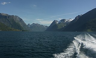
Hjørundfjorden is a fjord in the traditional district of Sunnmøre in Møre og Romsdal county, Norway. It is located mostly within Ørsta Municipality, although part of the mouth of the fjord is in Sykkylven Municipality. The 35-kilometre (22 mi) long fjord is an arm off of the larger Storfjorden that stretches south from Ålesund Municipality. Villages along the shores of the fjord include Bjørke, Leira, Viddal, Sæbø, and Store Standal.

Leira is a small village in the Hjørundfjord area of the municipality of Ørsta in Møre og Romsdal county, Norway. It lies between the villages of Bjørke and Viddal, at the end of Hjørundfjorden. The village is located in the Sunnmørsalpene mountains, about 6 kilometres (3.7 mi) from the mountains Skårasalen, Jakta, Kvitegga, and Hornindalsrokken.

Sæbø is a village in Ørsta Municipality in Møre og Romsdal county, Norway. The village is located along the Hjørundfjorden in the Bondalen valley. It is about 5 kilometres (3.1 mi) north of the mountain Skårasalen. The village of Store-Standal lies about 6 kilometres (3.7 mi) to the north and the villages of Leira and Bjørke lie about 11 kilometres (6.8 mi) to the south.
Vartdal is a former municipality in Møre og Romsdal county, Norway. The area of Vartdal is now a part of Ørsta Municipality. The administrative centre was the village Sætre, which is also known as Vartdal. The former municipality encompassed the northwestern part of present-day Ørsta Municipality, along the Vartdalsfjorden, including the villages of Flåskjer, Sætre, and Nordre Vartdal. The highway European route E39 highway runs along the edge of the fjord all the way through Vartdal. The main church for Vartdal was Vartdal Church, located in the village of Nordre Vartdal.

Hjørundfjord is a former municipality in Møre og Romsdal county, Norway. It is now a part of Ørsta Municipality. The administrative centre was the village of Sæbø, located on the shores of the Hjørundfjorden. The municipality encircled both sides of the Hjørundfjorden as well as the Bondalen valley. The villages of Bjørke, Leira, and Store Standal were all a part Hjørundfjord Municipality.

Ørsta–Volda Airport, Hovden is a regional airport situated at Hovden (Hovdebygda), in Ørsta, Norway, midway between the towns of Ørsta and Volda. The airport features a 1,070-meter (3,510 ft) asphalt runway aligned 06/24. Services are provided by Widerøe using their de Havilland Canada Dash 8 as a public service obligation. Owned and operated by the state-owned Avinor, the airport handled 121,021 passengers in 2014.

Store-Standal is a small village in the Hjørundfjord area of Ørsta Municipality in Møre og Romsdal county, Norway. The village has a population of approximately 20 people. Store-Standal is located along the Hjørundfjorden midway between the villages of Sæbø and Festøy. The village is located among the Sunnmørsalpene mountains, about 5.5 kilometres (3.4 mi) east of the mountain Kolåstinden. There is a ferry service from this village to Midt-Trandal and the on to Sæbø.

Skårasalen is a mountain in the municipality of Ørsta in Møre og Romsdal county, Norway. The 1,542-metre (5,059 ft) tall mountain has the seventh largest prominence of all mountains in Norway. The mountain is located about 5 kilometres (3 mi) south of the village of Sæbø and the Bondalen valley in the Hjørundfjord area of Ørsta. The nearby mountain, Jakta, lies directly to the east on the opposite side of the fjord.

Saudehornet is a mountain that is located 3 kilometres (1.9 mi) north of the village of Ørsta in the municipality of Ørsta in Møre og Romsdal county, Norway. The 1,303-metre (4,275 ft) is a very popular, though steep, destination for skiing in the Sunnmørsalpene range. It is located just north of the E39 highway, about 5 kilometres (3.1 mi) north of the Ørsta-Volda Airport, Hovden, and about 7 kilometres (4.3 mi) south of the village of Vartdal.

The Eiksund tunnel is an undersea tunnel in Møre og Romsdal county, Norway, which runs under the Vartdalsfjorden connecting Ørsta Municipality and Ulstein Municipality. The tunnel is 7,765 metres (25,476 ft) long and reaches a depth of −287 metres (−942 ft), which makes it the deepest undersea tunnel of its kind in the world.
Volda is the administrative centre of Volda Municipality in Møre og Romsdal county, Norway. The village is located on the northeastern shore of the Voldsfjorden, just less than 10 kilometres (6.2 mi) south of the village of Ørsta. The 3.6-square-kilometre (890-acre) village has a population (2013) of 6,114; giving the village a population density of 1,698 inhabitants per square kilometre (4,400/sq mi).

Ørsta is the administrative centre of Ørsta Municipality in Møre og Romsdal county, Norway. The village is located at the innermost part of the Ørstafjorden, surrounded by the Sunnmørsalpene mountains. The 5.4-square-kilometre (1,300-acre) urban area has a population (2012) of 6,868 which gives it a population density of 1,270 inhabitants per square kilometre (3,300/sq mi). This makes it the fourth largest urban area in all of Møre og Romsdal county.

Ørstafjorden is a fjord in Ørsta Municipality in Møre og Romsdal county, Norway. The 10-kilometre (6.2 mi) long fjord runs from the village of Ørsta to the Vartdalsfjorden. The fjord is about 2 kilometres (1.2 mi) wide and the deepest point in the fjord reaches 172 metres (564 ft) below sea level. The European route E39 highway runs along the eastern and southern shores of the fjord. The southern entrance to the Eiksund Tunnel is located along the western shore of the fjord. The inner parts of the fjord do freeze when there are extended periods of cold weather in the winters.

Ørsta Church is a parish church in Ørsta Municipality in Møre og Romsdal county, Norway. It is located in the village of Ørsta, at the end of the Ørstafjorden. The church is part of the Ørsta parish in the Søre Sunnmøre deanery in the Diocese of Møre. The white, wooden church was built in 1864 by the architects Heinrich Ernst Schirmer and Wilhelm von Hanno. The church seats about 350 people.

Nordre Vartdal is a village in the Vartdal area of Ørsta Municipality in Møre og Romsdal county, Norway. The village is located along the Vartdalsfjorden about 4 kilometres (2.5 mi) northeast of the village of Sætre. The village sits at the entrance to the Ådalen valley, at the mouth of the Storelva river. The European route E39 highway runs through Nordre Vartdal, right past Vartdal Church, which sits on the shore of the fjord.

Fredric Holen Bjørdal is a Norwegian politician for the Labour Party. He was elected to the Parliament of Norway from Møre and Romsdal in 2013.


