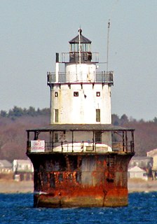
Spring Point Ledge Light is a sparkplug lighthouse in South Portland, Maine that marks a dangerous obstruction on the west side of the main shipping channel into Portland Harbor. It is now adjacent to the campus of Southern Maine Community College.

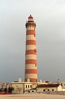
West Quoddy Head, in Quoddy Head State Park, Lubec, Maine, is the easternmost point of the contiguous United States. Since 1808, there has been a lighthouse there to guide ships through the Quoddy Narrows. The current one, with distinctive red-and-white stripes, was built in 1858, and is an active aid to navigation. Photographs and paintings of this lighthouse are frequently reproduced. The 3rd order Fresnel lens is the only 3rd order and one of only eight Fresnel lenses still in use on the Maine Coast.
Butler Flats Light is a sparkplug lighthouse located in the outer harbor of New Bedford, Massachusetts, at the mouth of the Acushnet River. Built in 1898 by the United States Lighthouse Board, it is the only known caisson lighthouse designed by a marine architect. The light was added to the National Register of Historic Places as Butler Flats Light Station on June 15, 1987. Automated in 1978, it is now operated by the city as a private aid to navigation.

Little Gull Island Light is a lighthouse on Little Gull Island, off Fisher's Island, New York in Long Island Sound.

The Fort Point Light, or Fort Point Light Station, is located in Fort Point State Park, in Stockton Springs, Maine. A lighthouse at this point has served as an active aid to navigation since 1835; the present lighthouse dates to 1857, and is listed on the National Register of Historic Places.

Marshall Point Light Station is a lighthouse at the entrance of Port Clyde Harbor in Port Clyde, Maine. The light station was established in 1832.

Deer Island Light is a lighthouse in Boston Harbor, Boston, Massachusetts. The actual light is 53 feet (16 m) above Mean High Water. Its alternating white and red light is visible for 9 nautical miles.

The Doubling Point Range Lights are a pair of range lights on the Kennebec River, in Arrowsic, Maine. Built in 1898 as part of a major improvement on navigational aids on the river, they are the only surviving pair of range lights in the state. They were listed on the National Register of Historic Places as Kennebec River Light Station on January 21, 1988.

Curtis Island Light, originally Negro Island Light, is a lighthouse marking the approach to the harbor of Camden, Maine. It is located on Curtis Island, which shelters the harbor from ocean storms. It was first established in 1835, and the present structure was built in 1896. The light was automated in 1972, and listed on the National Register of Historic Places in 1973.

Egg Rock Light is a lighthouse on Frenchman Bay, Maine. Built in 1875, it is one of coastal Maine's architecturally unique lighthouses, with a square tower projecting through the square keeper's house. Located on Egg Rock, midway between Mount Desert Island and the Schoodic Peninsula, it is an active aid to navigation, flashing red every 40 seconds. The light was listed on the National Register of Historic Places as Egg Rock Light Station in 1988.

Great Duck Island Light is a lighthouse on Great Duck Island in the town of Frenchboro, Maine, USA. Established in 1890, the light marks the approach to Blue Hill Bay and the southern approaches to Mount Desert Island on the central coast of Maine. The light was listed on the National Register of Historic Places as Great Duck Island Light Station on March 14, 1988. The light is an active aid to navigation maintained by the United States Coast Guard; the property is owned by the College of the Atlantic, which operates a research station there.

Hendricks Head Light is a lighthouse in Southport, Maine marking the west side of the mouth of the Sheepscot River. The light station was established in 1829, and its present structures date to 1875. It was deactivated in 1933, but relit in 1951. The two-story wood keeper's house is now a private summer residence. The light is on continuously, showing white to the west and red to the east. It was listed on the National Register of Historic Places as Hendricks Head Light Station on November 20, 1987.

Heron Neck Light is a lighthouse on Green's Island in Vinalhaven, Maine at the south end of Penobscot Bay. It was established in 1854 as an aid to navigation for Vinalhaven's main port, and for the Hurricane Channel extending northwest from Heron's Neck. The light was automated in 1984. It was listed on the National Register of Historic Places as Heron Neck Light Station on January 21, 1988.

Libby Island Light is a lighthouse on Libby Island, marking the mouth of Machias Bay, in Machiasport, Maine. The light station was established in 1817 and is an active aid to navigation; the present granite tower was built in 1823 and improved in 1848. Libby Island Light was listed on the National Register of Historic Places as Libby Island Light Station on June 18, 1976.
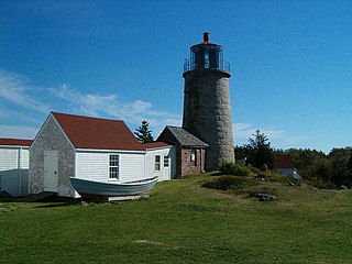
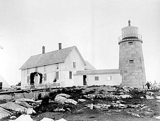
Monhegan Island Light is a lighthouse on Monhegan Island, Maine. It was first established in 1824. The present structure was built in 1850. It was Alexander Parris's last significant design. It is the second highest light in Maine — Seguin Light, with a 6-foot taller tower, is 2 feet higher in elevation. It was listed on the National Register of Historic Places as Monhegan Island Lighthouse and Quarters on May 7, 1980, reference number 80000239.

Two Bush Island Light is a lighthouse on Two Bush Island, on the channel of the same name, the southwestern entrance to Penobscot Bay, Maine. The two bushes for which the island was named have long since vanished. The lighthouse was established in 1897. The keepers were removed when the light was automated in 1964. Afterward, the Two Bush Island fog signal was operated by the keepers at nearby Whitehead Light Station, who also monitored the light. The keeper's house was destroyed in 1970 as a Green Beret demolition exercise. In the summer of 2000, the light was converted to solar power. The lighthouse itself continues to be a navigation aid, but is only visible by boat or from the air. In 1998, the lighthouse became the property of the U.S. Fish and Wildlife Service.
Whitehead Light is a lighthouse on Whitehead Island, on Muscle Ridge Channel, in the southwestern entrance to Penobscot Bay, Maine. It is in the town of St.George. Established in 1804, it is one of Maine's oldest light stations, with its present tower built in 1852 to a design attributed to Alexander Parris. It was listed on the National Register of Historic Places as Whitehead Light Station on March 14, 1988. The property is now owned by not for profit Pine Island Camp. Whitehead light station offers to the public various stays at the light station from getaway weekends to learning retreats and renting the station as a vacation home. The light itself remains an active aid to navigation, maintained by the United States Coast Guard.