Forest of la Coubre

Last updated

The forest of la Coubre near La Tremblade. Foret de la Coubre 027.jpg
The forest of la Coubre near La Tremblade.

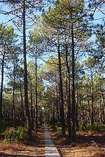
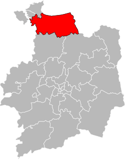
The Forest of la Coubre (French : forêt de la Coubre) is a large forest in the region of Nouvelle-Aquitaine, near the city of Royan. Its area is roughly 7916 hectares, [1] making it the third largest forêt domaniale (French State's inalienable domaine) of the north of the region, behind forest of la Double and the forest d'Horte.

French language Romance language

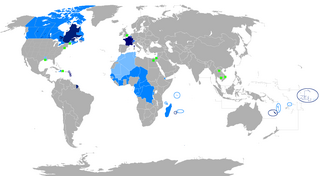
French is a Romance language of the Indo-European family. It descended from the Vulgar Latin of the Roman Empire, as did all Romance languages. French evolved from Gallo-Romance, the spoken Latin in Gaul, and more specifically in Northern Gaul. Its closest relatives are the other langues d'oïl—languages historically spoken in northern France and in southern Belgium, which French (Francien) has largely supplanted. French was also influenced by native Celtic languages of Northern Roman Gaul like Gallia Belgica and by the (Germanic) Frankish language of the post-Roman Frankish invaders. Today, owing to France's past overseas expansion, there are numerous French-based creole languages, most notably Haitian Creole. A French-speaking person or nation may be referred to as Francophone in both English and French.

Nouvelle-Aquitaine Administrative region of France

Nouvelle-Aquitaine is the largest administrative region in France, located in the southwest of the country. The region was created by the territorial reform of French Regions in 2014 through the merger of three regions: Aquitaine, Limousin and Poitou-Charentes. It covers 84,061 km2 (32,456 sq mi) – or ​18 of the country – and has approximately 5,800,000 inhabitants.. The new region was established on 1 January 2016, following the regional elections in December 2015.

Royan Commune in Nouvelle-Aquitaine, France

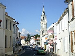
Royan is a commune and town in the south-west of France, in the department of Charente-Maritime in the Nouvelle-Aquitaine region. Its inhabitants are known as Royannais and Royannaises. Capital of the Côte de Beauté, Royan is one of the main French Atlantic coastal resort towns, and has five beaches, a marina for over 1,000 boats, and an active fishing port. As of 2013, the population of the greater urban area was 48,982. The town had 18,393 inhabitants in 2015.

Around its remaining perimeter, it contains or is adjacent to numerous communes including La Tremblade, Les Mathes, Arvert, Étaules, Saint-Augustin and Saint-Palais-sur-Mer. It borders the atlantic ocean, the Gironde estuary and the forest of the Combots d'Ansoine. The forest of la Coubre is composed mostly of maritime pine. This pine plantation was started in the 19th century by Médéric de Vasselot de Régné in the Pointe de la Coubre area, to halt erosion.

La Tremblade Commune in Nouvelle-Aquitaine, France

La Tremblade is a commune in the Charente-Maritime department and Nouvelle-Aquitaine region in south-western France.

Les Mathes Commune in Nouvelle-Aquitaine, France

Les Mathes is a commune in the Charente-Maritime department and Nouvelle-Aquitaine region in southwestern France.

Arvert Commune in Nouvelle-Aquitaine, France

Arvert is a French commune in the Charente-Maritime department and Nouvelle-Aquitaine region of south-western France.

The EuroVelo bicycle route (Atlantic Coast route) cross the forest.

EuroVelo transport network

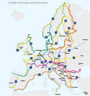
EuroVelo is a network of long-distance cycling routes criss-crossing Europe, in various stages of completion. As of May 2013 more than 45,000 km (27,962 mi) were in place. The network is scheduled for substantial completion by 2020 and when finished, the EuroVelo network's total length will exceed 70,000 km (43,496 mi). EuroVelo is a project of the European Cyclists' Federation (ECF).

Related Research Articles

Dompierre-les-Ormes Commune in Bourgogne-Franche-Comté, France

Dompierre-les-Ormes is a commune in the department of Saône-et-Loire in Bourgogne-Franche-Comté, France.

Landes forest forest in France

The Landes forest or the Landes of Gascony, in the historic Gascony natural region of southwestern France now known as Aquitaine, is the largest man-made woodland in Western Europe. The French word, landes and Gascon lanas, mean 'moors' or 'heaths'.

Étaules, Charente-Maritime Commune in Nouvelle-Aquitaine, France

Étaules is a commune in the Charente-Maritime department and Nouvelle-Aquitaine region in southwestern France.

Bastelica Commune in Corsica, France

Bastelica is a commune in the Corse-du-Sud department of France on the island of Corsica.

The once vast Forêt de Rouvray was a forest that extended from west of Paris in the Île-de-France region westwards into Normandy, virtually unbroken, threaded by the winding loops of the River Seine, traversed by forest traces and dotted with isolated woodland hamlets, as far as Rouen. A rural relict is the 5 100 ha of the protected Forêt Domaniale de la Londe-Rouvray, at Les Essarts, Normandy, near Saint-Étienne-du-Rouvray, south of Rouen, on an upland massif above the left bank of the Seine, which makes a wide arc enclosing it. On the right bank, to the west, is what is left of the Forêt de Roumare, another former royal forest.

Sainte-Martine, Quebec Municipality in Quebec, Canada

Sainte-Martine is a municipality in Beauharnois-Salaberry Regional County Municipality in the Montérégie region of Quebec, Canada. The population as of the Canada 2016 Census was 5,461. The municipality is made up of a large northern section and a small unattached southern area that was known as the municipality of Saint-Paul-de-Châteauguay until its merger with Sainte-Martine on September 9, 1999.

The Canton of Bolbec is a canton situated in the Seine-Maritime département and in the Normandy region of northern France.

Forest of Tronçais

The Forest of Tronçais is a national forest comprising 10,600 hectares in the Allier department of central France. It is managed by the National Forests Office (ONF). Its oaks, planted by Louis XIV's minister Jean-Baptiste Colbert to supply the French Navy, constitute one of the principal stands of oaks in Europe.

Orient Forest Regional Natural Park regional natural park of France

Orient Forest Regional Natural Park is a protected area of woodlands and lakes in the Champagne-Ardenne region of France. It covers a total area of 70,000 hectares The parkland encompasses the large Forest of Orient as well as three man-made lakes: Lac d'Orient, Lac du Temple, and Lac Amance. The area was officially designated as a regional natural park in 1970.

Lighthouse of La Coubre lighthouse in Charente-Maritime, France

The Lighthouse of La Coubre is a lighthouse located in La Tremblade, in Charente-Maritime, in France. It is 64 meters high and is the highest in the departement. A museum tells the history of the different lighthouses that have existed in the region. It is possible to climb at the top from February to November.

The Marais breton is a zone géographique humide along France's Atlantic coast. It marks the border between two traditional French provinces, Brittany and Poitou, and extends between two French departments, Loire-Atlantique and Vendée, both of which included in the administrative region of Pays de la Loire.

Côte de Beauté

The Côte de Beauté is a part of the south-western coastline of France, situated south of the peninsula of Arvert, in the department of Charente-Maritime. Its capital is the town of Royan.

Cerisy Forest

Cerisy Forest, is a 2,127-hectare (5,260-acre) beech woodland, located in the French Calvados and Manche departments.

Canton of Dol-de-Bretagne Canton in Brittany, France

The Canton of Dol-de-Bretagne is a canton of France, in the Ille-et-Vilaine département, located in the north of the department. At the French canton reorganisation which came into effect in March 2015, the canton was expanded from 8 to 31 communes.

The canton of Les Trois Monts is an administrative division of the Charente-Maritime department, western France. It was created at the French canton reorganisation which came into effect in March 2015. Its seat is in Montendre.

The canton of Domont is an administrative division of the Val-d'Oise department, Île-de-France region, northern France. Its borders were modified at the French canton reorganisation which came into effect in March 2015. Its seat is in Domont.

The canton of Eymoutiers is an administrative division of the Haute-Vienne department, western France. Its borders were modified at the French canton reorganisation which came into effect in March 2015. Its seat is in Eymoutiers.

The canton of Saint-Ours is an administrative division of the Puy-de-Dôme department, central France. It was created at the French canton reorganisation which came into effect in March 2015. Its seat is in Saint-Ours.

References

Further reading

Coordinates: 45°43′30″N1°12′18″W / 45.725°N 1.205°W / 45.725; -1.205

Geographic coordinate system Coordinate system

A geographic coordinate system is a coordinate system that enables every location on Earth to be specified by a set of numbers, letters or symbols. The coordinates are often chosen such that one of the numbers represents a vertical position and two or three of the numbers represent a horizontal position; alternatively, a geographic position may be expressed in a combined three-dimensional Cartesian vector. A common choice of coordinates is latitude, longitude and elevation. To specify a location on a plane requires a map projection.