
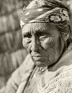
The Fort Bidwell Indian Community of the Fort Bidwell Reservation of California is a federally recognized tribe of Northern Paiute Indians in Modoc County in the northeast corner of California. [1]
The Fort Bidwell Indian Community of the Fort Bidwell Reservation of California is a federally recognized tribe of Northern Paiute Indians in Modoc County in the northeast corner of California. [1]
The population as of 1969 was 112. [2] The agency is the Northern California agency. The principal tribe is Paiute. They had laws and regulations, in order to establish a legal community organization and secure certain privileges and powers offered to us by the Indian Reorganization Act, they established a constitution and by-laws for the Fort Bidwell Indian Community. There were various laws placed on membership, territory, land as well as amendments. [3]


The Fort Bidwell Indian Community has a federal reservation, the Fort Bidwell Reservation, in Modoc County, near the town of Fort Bidwell, California. The reservation is 3,335 acres (13.50 km2) large. Approximately 108 tribal members live on the reservation. [1] The reservation was established in 1897. In 1990 only 6 tribal members lived on the reservation. In 1992, 22 people were enrolled in the tribe. [4] The tribal members are members the Northern Paiute Kidütökadö band (Gidu Ticutta - ‘Yellow-bellied marmot-Eaters’, also called "Northern California Paiute").
The Fort Bidwell Indian Community traditionally spoke the Northern Paiute language, which is part of the Western Numic branch of the Uto-Aztecan language family. [5] The language family is Numic, and the language phylum is Aztec-Tanoan. [6] The word Numic comes from the cognate word in all Numic languages for "person". This language is still in use and also spoken fluently by the people of Fort Bidwell. This language is most closely related to the Mono language of California. [6]
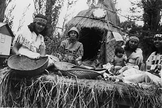
For this tribe the activities include occasional marksmanship, which sometimes was played as competition. [7] They have large areas of land which are used for farming, so that is another activity for the people of Fort Bidwell, California. Drumming, and family fun were the highlights of the celebrations held at the Fort Bidwell Indian reservation. The vendors sold food items, art work, and beading supplies at these celebrations. Dancing was also a common activity, in which women wore fancy shawls when dancing. [8]
In the state legislature, Fort Bidwell is in the 1st Senate District, represented by Republican Ted Gaines, and the 1st Assembly District, represented by Republican Brian Dahle. Federally, Fort Bidwell is in California's 1st congressional district, represented by Republican Doug LaMalfa. Fort Bidwell is now registered as California Historical Landmark #430. The tribal affiliation is Paiute Reservation. The Fort Bidwell Reservation Population within the reservation is around 124. Adjacent to the reservation there about 39 people. The land base is 1350 ha (3,335 acres). The tribal office is at PO Box 129, Fort Bidwell, CA 96112. A joint resolution of January 30, 1879, authorized the secretary of the interior to use the abandoned Fort Bidwell Military Reserve for an Indian Training School. [9]
An act of January 27, 1913, granted land to the People's Church for a cemetery and right-of-way over the Fort Bidwell Indian School Reservation, the Indians to have right of interment therein. The Reservation was established by Executive Order on October 9, 1866. The Fort Bidwell community is of the Modoc County, California. The Tribal government was established on January 28, 1936 under the Indian Reorganization Act of 1934. The Tribe has approximately 350 members, although only about 160 currently reside on the Reservation. [10]
The tribe's headquarters is located in Fort Bidwell, California. The tribe is governed by a nine tribal council members [4] as well as a chairman, vice chairman, treasurer, and secretary.
The reservation is served by the Surprise Valley Joint Unified School District.
The Klamath people are a Native American tribe of the Plateau culture area in Southern Oregon and Northern California. Today Klamath people are enrolled in the federally recognized tribes:

The Northern Paiute people are a Numic tribe that has traditionally lived in the Great Basin region of the United States in what is now eastern California, western Nevada, and southeast Oregon. The Northern Paiutes' pre-contact lifestyle was well adapted to the harsh desert environment in which they lived. Each tribe or band occupied a specific territory, generally centered on a lake or wetland that supplied fish and waterfowl. Communal hunt drives, which often involved neighboring bands, would take rabbits and pronghorn from surrounding areas. Individuals and families appear to have moved freely among the bands.
The Shoshone or Shoshoni are a Native American tribe with four large cultural/linguistic divisions:

The Indigenous peoples of the Great Basin are Native Americans of the northern Great Basin, Snake River Plain, and upper Colorado River basin. The "Great Basin" is a cultural classification of indigenous peoples of the Americas and a cultural region located between the Rocky Mountains and the Sierra Nevada, in what is now Nevada, and parts of Oregon, California, Idaho, Wyoming, and Utah. The Great Basin region at the time of European contact was ~400,000 sq mi (1,000,000 km2). There is very little precipitation in the Great Basin area which affects the lifestyles and cultures of the inhabitants.
The Indigenous peoples of Arizona are the Native American people of the state of Arizona. These include people that have lived in the region since time immemorial; tribes who entered the region centuries ago, such as the Southern Athabascan peoples; and the Pascua Yaqui who settled in Arizona in mass in the early 20th century, though small numbers had settled in the United States prior.

The Mono are a Native American people who traditionally live in the central Sierra Nevada, the Eastern Sierra, the Mono Basin, and adjacent areas of the Great Basin. They are often grouped under the historical label "Paiute" together with the Northern Paiute and Southern Paiute - but these three groups, although related within the Numic group of Uto-Aztecan languages, do not form a single, unique, unified group of Great Basin tribes.
The Big Pine Band of Owens Valley Paiute Shoshone Indians of the Big Pine Reservation are a federally recognized tribe of Mono and Timbisha Indians in California.

The Chemehuevi Indian Tribe of the Chemehuevi Reservation is a federally recognized tribe of Chemehuevi people, who are the southernmost branch of Southern Paiute people.

Surprise Valley is a valley in extreme northeastern California, about 60 miles in length from north to south. Locals refer to the area as the Tricorner Region because of the region's location at the intersection of California, Oregon, and Nevada state lines. The valley is east of the Modoc County seat of Alturas. The area is part of the Great Basin which extends across most of the northern half of Nevada.

The Bridgeport Indian Colony of California, formerly known as the "Bridgeport Paiute Indian Colony of California", is a federally recognized tribe of Northern Paiute Indians in Mono County, California, United States.

The Burns Paiute Tribe of the Burns Paiute Indian Colony of Oregon is a federally recognized tribe of Northern Paiute Indians in Harney County, Oregon, United States.
The Lovelock Paiute Tribe of the Lovelock Indian Colony is a federally recognized tribe of Northern Paiute Indians in Pershing County, Nevada.
The Bishop Paiute Tribe, formerly known as the Paiute-Shoshone Indians of the Bishop Community of the Bishop Colony is a federally recognized tribe of Mono and Timbisha Indians of the Owens Valley, in Inyo County of eastern California. As of the 2010 Census the population was 1,588.
The Paiute-Shoshone Indians of the Lone Pine Community of the Lone Pine Reservation is a federally recognized tribe of Mono and Timbisha Native American Indians near Lone Pine in Inyo County, California. They are related to the Owens Valley Paiute.

The Summit Lake Paiute Tribe of Nevada is a federally recognized tribe of Northern Paiute Indians in northwest Nevada. Their autonym in their language is Agai Panina Ticutta, meaning "Fish Lake Eaters." They are traditionally known as the "Fish Eaters."
The XL Ranch is an Indian reservation located in Modoc County, north of Burney, California.
The Likely Rancheria is a federal Indian reservation belonging to the Pit River Tribe, a federally recognized tribe of indigenous people of California. The ranchería is located in Modoc County in northern California.
The Cedarville Rancheria is a federally recognized tribe of Northern Paiute people in Modoc County, California, about 30 miles (48 km) south of the Oregon border. Cedarville Rancheria is 26 acres in Cedarville. The tribal headquarters is located 20 miles away from the Rancheria in Alturas. The tribe has an environmental protection agency that is dedicated to keeping the Rancheria clean and teaching children how to protect and care for the planet.
The Fort Independence Indian Community of Paiute Indians of the Fort Independence Reservation is a federally recognized tribe of Paiute and Shoshone people in the Owens Valley, in Inyo County, eastern California. As of the 2010 Census the population was 93.
The Fort McDermitt Paiute and Shoshone Tribe is a federally recognized tribe of Northern Paiute and Western Shoshone peoples, whose reservation Fort McDermitt Paiute and Shoshone Tribes of the Fort McDermitt Indian Reservation spans the Nevada and Oregon border next to Idaho. The reservation has 16,354 acres (6,618 ha) in Nevada and 19,000 acres (7,700 ha) in Oregon.
Coordinates: 41°51′39″N120°11′14″W / 41.86083°N 120.18722°W
Municipalities and communities of Modoc County, California, United States | ||
|---|---|---|
| City |  | |
| CDPs | ||
| Unincorporated communities | ||
| Indian reservations | ||
| Former settlements | ||