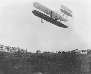
Fort Myer is the previous name used for a U.S. Army post next to Arlington National Cemetery in Arlington County, Virginia, and across the Potomac River from Washington, D.C. Founded during the American Civil War as Fort Cass and Fort Whipple, the post merged in 2005 with the neighboring Marine Corps installation, Henderson Hall, and is today named Joint Base Myer–Henderson Hall.

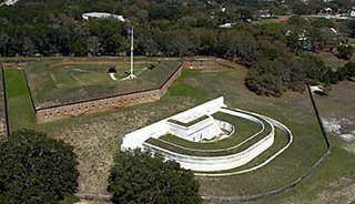
Fort Macon State Park is a North Carolina state park in Carteret County, North Carolina, in the United States. Located on Bogue Banks near Atlantic Beach, the park opened in 1936. Fort Macon State Park is the second most visited state park in North Carolina, with an annual visitation of 1.3 million, despite being one of the smallest state parks in North Carolina with 424 acres (1.72 km2). Fort Macon was built as part of the Third System of US fortifications, and was preceded by Fort Hampton of the Second System.

Fort Pillow State Historic Park is a state park in western Tennessee that preserves the American Civil War site of the Battle of Fort Pillow. The 1,642 acre (6.6 km²) Fort Pillow, located in Lauderdale County on the Chickasaw Bluffs overlooking the Mississippi River, is rich in both historic and archaeological significance. In 1861, the Confederate army built extensive fortifications and named the site for General Gideon Johnson Pillow of Maury County. It was attacked and held by the Union Army for most of the American Civil War period except immediately after the Battle of Fort Pillow, when it was retaken by the Confederate Army. Many African-American soldiers were killed in what modern historians describe as a "massacre" or "atrocity". Interpretive sites are part of the park.

Fort Moultrie is a series of fortifications on Sullivan's Island, South Carolina, built to protect the city of Charleston, South Carolina. The first fort, formerly named Fort Sullivan, built of palmetto logs, inspired the flag and nickname of South Carolina, as "The Palmetto State". The fort was renamed for the U.S. patriot commander in the Battle of Sullivan's Island, General William Moultrie. During British occupation, in 1780–1782, the fort was known as Fort Arbuthnot.

Fort Monroe, preserved as the Fort Monroe National Monument, is a decommissioned military installation in Hampton, Virginia, at Old Point Comfort, the southern tip of the Virginia Peninsula, United States. Along with Fort Wool, Fort Monroe originally guarded the navigation channel between the Chesapeake Bay and Hampton Roads—the natural roadstead at the confluence of the Elizabeth, the Nansemond and the James rivers. Until disarmament in 1946, the areas protected by the fort were the entire Chesapeake Bay and Potomac River regions, including the water approaches to the cities of Washington, D.C. and Baltimore, Maryland, along with important shipyards and naval bases in the Hampton Roads area. Surrounded by a moat, the six-sided bastion fort is the largest fort by area ever built in the United States.

Fort Fisher was a Confederate fort during the American Civil War. It protected the vital trading routes of the port at Wilmington, North Carolina, from 1861 until its capture by the Union in 1865. The fort was located on one of Cape Fear River's two outlets to the Atlantic Ocean on what was then known as Federal Point or Confederate Point and today is known as Pleasure Island. The strength of Fort Fisher led to its being called the Southern Gibraltar and the "Malakoff Tower of the South". The battle of Fort Fisher was the most decisive battle of the Civil War fought in North Carolina.
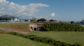
Fort Barrancas (1839) or Fort San Carlos de Barrancas is a United States military fort and National Historic Landmark in the former Warrington area of Pensacola, Florida, located physically within Naval Air Station Pensacola, which was developed later around it.

Fort Ethan Allen was an earthwork fortification that the Union Army built in 1861 on the property of Gilbert Vanderwerken in Alexandria County, Virginia, as part of the Civil War defenses of Washington. The remains of the fort are now within Arlington County's Fort Ethan Allen Park.

Fort Howell is an earthworks fort built in 1864 during the American Civil War, located on Hilton Head Island, South Carolina. It was named in honor of Union Army Brigadier General Joshua B. Howell, and Its primary function was to protect Mitchelville, a Freedman's town located to its east.

Fort Foster is a Second Seminole War era fort in central Florida, located 9 miles (14 km) south of current-day Zephyrhills in Pasco County.

Fort O'Brien State Historic Site, also known as Fort Machias, preserves the remains of a fort located in Machiasport, Maine that was built and destroyed three times over a 90-year period. It was involved in military actions during the American Revolutionary War and the War of 1812, and was listed on the National Register of Historic Places. It is now managed by the Maine Department of Conservation's Bureau of Parks and Lands, and is open between Memorial Day and Labor Day.

Fort Amherst is a neighbourhood in St. John's, Newfoundland and Labrador. It is located at 47°33′48.96″N52°40′49.60″W, on the southern side of the Narrows, the entrance to St. John's harbour. Apart from some family dwellings, Fort Amherst consists of a man-made harbour, a lighthouse and the remains of gun emplacements built during World War II to defend against German U-boats. Two QF 4.7-inch B Mark IV* guns remain in place, and can still be seen on their mountings.
The Charlesfort-Santa Elena Site is an important early colonial archaeological site on Parris Island, South Carolina. It contains the archaeological remains of a French settlement called Charlesfort, settled in 1562 and abandoned the following year, and the later 16th-century Spanish settlement known as Santa Elena. The Spanish remains include a fort built directly on top of the abandoned Charlesfort remains. This fort and other nearby structures have been called, at various times, Fort San Marcos, Fort San Felipe, and have the designated archaeological site identifiers 38BU51 and 38BU162. Because of their remarkable state of preservation, and their importance in understanding early French and Spanish colonial practices, the site was designated a National Historic Landmark in 2001. The site is accessible through the United States Marine Corps Recruit Depot in Port Royal, South Carolina.

Fort DeRussy, located south of Alexandria, Louisiana, and four miles (6 km) north of Marksville, was a Confederate earthwork stronghold during the American Civil War. It was built in 1862 to defend the lower Red River Valley in Louisiana. Located in Avoyelles Parish, the fort, cemetery and water batteries were designated as a state historic site in 1994. The fort and the water battery were listed on the National Register of Historic Places in 2016.
Fort Pemberton was one of the larger confederate forts was constructed in the defense of Charleston, South Carolina during the American Civil War. When Charleston was overwhelmed by Union forces in 1861, it became evident that control of the western regions of James Island and the Stono River was to be an important element in the defense of the city. Confederate military authorities of the time believed that Union occupation of James Island would leave Charleston subject to attack from the southeast. From this position the city would assuredly fall to the Union. Although there were many gun batteries in place along the south and east side of James Island, Fort Pemberton was the only fortress in defense of this region.

Santee Indian Mound and Fort Watson is a historic archaeological site located near Summerton, Clarendon County, South Carolina. Santee Indian Mound was part of a Santee mound village complex; it was probably a burial and/or temple mound, likely constructed in some cultural period between 1200–1500.

Fort Johnson is a state-owned historic site of military and political significance located on the northeast point of James Island in Charleston County, South Carolina.
Folly North Site (38CH1213), also known as Little Folly Island, is a historic archaeological site located at Folly Beach, Charleston County, South Carolina. The site contains the extant remains of two American Civil War artillery batteries constructed by the Union Army in 1863. Artifacts associated with eight other batteries and Fort Green have likely eroded into the Atlantic Ocean. The batteries and fortifications were built as part of the Union effort to capture Charleston, South Carolina.
Located in North Carolina on the Atlantic Coast, the Fort Caswell Historic District encompasses 2 sites, 43 buildings, and 23 structures; it was added to the National Register of Historic Places in 2013. The fort itself was occupied by various branches of the U.S. armed forces for most of the period between 1836 and 1945 and is now a part of the North Carolina Baptist Assembly, a Christian retreat, owned and operated by the Baptist State Convention of NC. It is accessible by the public to a limited extent per the conditions set forth by the Assembly’s Director.
Fort Juelson, designated 21OT198 in the state archaeological inventory, is a historic site located east of Underwood, Minnesota, United States. An earthen fort was built at this hilltop in July 1876 after rumors of Indian attacks in Foxhome, French, and Fergus Falls following the Battle of Little Bighorn in Montana. Many settlers left the area. Charles A. Dollner, a local merchant, suggested the rest of the people band together and build the fortification under leadership of two American Civil War veterans, Hans Juelson and Berge O. Lee. The scare proved to be a hoax, and the fort was never used for defensive purposes. Remnants of the sod barricade are still on the site.


