Rock County is a county in the U.S. state of Nebraska. As of the 2010 United States Census, the population was 1,526. Its county seat is Bassett.
Knox County is a county in the U.S. state of Nebraska. As of the 2010 United States Census, the population was 8,701. Its county seat is Center. Knox County was named for Continental and U.S. Army Major General Henry Knox.

Cherry County is a county in the U.S. state of Nebraska. As of the 2010 United States Census, the population was 5,713. Its county seat is Valentine. The county was named for Lt. Samuel A. Cherry, an Army officer who was stationed at Fort Niobrara and who had been killed in South Dakota in 1881. Cherry County is in the Nebraska Sandhills.

The Niobrara River is a tributary of the Missouri River, approximately 568 miles (914 km) long, running through the U.S. states of Wyoming and Nebraska. The river drains one of the most arid sections of the Great Plains, and has a low flow for a river of its length. The Niobrara's watershed includes the northern tier of Nebraska Sandhills, a small south-central section of South Dakota, as well as a small area of eastern Wyoming.

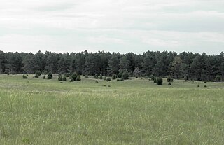
The Sandhills, often written Sand Hills, is a region of mixed-grass prairie on grass-stabilized sand dunes in north-central Nebraska, covering just over one quarter of the state. The dunes were designated a National Natural Landmark in 1984.

The Niobrara National Scenic River is in north-central Nebraska, United States, approximately 300 miles (480 km) northwest of Omaha. In 1991, Congress set aside 76 miles (120 km) for preservation under the management of the National Park Service with assistance from the local Niobrara Council. Several "outstandingly remarkable values" have been designated to be protected along the Niobrara National Scenic River, including: Fish and Wildlife, Scenery, Fossil Resources, Geology, and Recreation. The river was designated by Backpacker magazine as one of the 10 best rivers for canoeing in the United States.

The Pine Ridge is an escarpment between the Niobrara River and the White River in far northwestern Nebraska. The high tableland between the rivers has been eroded into a region of forested buttes, ridges and canyons.

Boyer Chute National Wildlife Refuge, created in 1992, is a National Wildlife Refuge (NWR) located along the banks of the Missouri River in the U.S. state of Nebraska. The 4,040-acre (1,630 ha) refuge preserves an area that had been cultivated and neglected before the early 1990s. Channelization projects along the Missouri River to improve flood control and navigation resulted in the closing off a side branch of the river, known since the early 19th century as Boyer Chute. Between 1820 and 1937 the Missouri River had migrated 3 mi (4.8 km) eastward and the area of the chute had originally been on the east bank of the river; today, the chute is west of the main channel of the Missouri. In 1937, the Army Corps of Engineers began to rechannel portions of the Missouri River, cutting off the chute to flowing water. Overgrowth and cultivation took over the lands now preserved in the refuge. Restoration of the area commenced in 1993; this included planting 9,100 native plants and trees and restoring the inflow to the chute from the main channel of the Missouri River.
The Samuel R. McKelvie National Forest is a United States National Forest located in the north-central Sandhills region of the U.S. state of Nebraska. The total area of the national forest is 116,079 acres (469.76 km2). The forest is managed by the U.S. Forest Service's Nebraska Forests and Grasslands Supervisor's Office in Chadron, Nebraska. The national forest is located entirely within Cherry County, Nebraska. There is a local ranger district office located in Nenzel.
The Missouri National Recreational River is a National Recreational River located on the border between Nebraska and South Dakota. The designation was first applied in 1978 to a 59-mile section of the Missouri River between Gavins Point Dam and Ponca State Park. In 1991, an additional 39-mile section between Fort Randall Dam and Niobrara, Nebraska, was added to the designation. These two stretches of the Missouri River are the only parts of the river between Montana and the mouth of the Missouri that remain undammed or unchannelized. The last 20 miles of the Niobrara River and 6 miles of Verdigre Creek were also added in 1991.

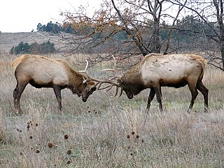
Valentine National Wildlife Refuge is located in the U.S. state of Nebraska and includes 19,131 acres (77.42 km2). The refuge protects a portion of the largest remaining area of tall and mid grass prairie remaining in the U.S. Collectively known as the sand hills region of Nebraska, the dunes were the end result of the last ice age known as the Pinedale glaciation. During the Holocene glacial retreat the sand dunes that been deposited in their current location by the vast continental glaciers, were exposed and grasses eventually took over. The refuge is managed by the U.S. Fish and Wildlife Service and along with Fort Niobrara and John and Louise Seier National Wildlife Refuges, they form the Fort Niobrara National Wildlife Refuge Complex. In 1976, the Valentine National Wildlife Refuge was designated as a National Natural Landmark by the National Park Service.
John and Louise Seier National Wildlife Refuge is located in the U.S. state of Nebraska and includes 2,400 acres (9.71 km2). The refuge protects a portion of the largest remaining area of tall and mid grass prairie remaining in the U.S. Collectively known as the Sand Hills region of Nebraska, the dunes were the end result of the last ice age known as the Pinedale glaciation. During the Holocene glacial retreat the sand dunes that been deposited in their current location by the vast continental glaciers, were exposed and grasses eventually took over. The refuge is managed by the U.S. Fish and Wildlife Service and along with Fort Niobrara and Valentine National Wildlife Refuges, form the Fort Niobrara National Wildlife Refuge Complex.
DeSoto National Wildlife Refuge, created in 1958, is located along the banks of the Missouri River in the U.S. states of Iowa and Nebraska. The 8,362-acre (33.83 km2) refuge preserves an area that would have been otherwise lost to cultivation. In 1960, an Army Corps of Engineers channelization project on the Missouri River moved the main river channel in the area to the west. The former river channel became DeSoto Lake, a seven-mile long oxbow lake. As a result, part of the Nebraska portion of the refuge lies on the east side of the Missouri River.
Nanza is the Ponca name for what is now called Ponca Fort. It was a fortified village built by the Ponca in the vicinity of present-day Niobrara, Nebraska, USA, in circa 1700 and occupied until about 1865.

Nebraska Highway 12 is a highway in northern and northeastern Nebraska. It has a western terminus at U.S. Highway 83 in Valentine and an eastern terminus at U.S. Highway 20 west of Jackson. The highway largely lies within 10 miles (16 km) of the South Dakota border its entire length. The highway has been designated the Outlaw Trail Scenic Byway.

The American Bison Society (ABS) was founded in 1905 by pioneering conservationists and sportsmen including William T. Hornaday and Theodore Roosevelt to help save the bison from extinction and raise public awareness about the species.
The Niobrara Reservation is a former Indian Reservation in northeast Nebraska. It originally comprised lands for both the Santee Sioux and the Ponca, both Siouan-speaking tribes, near the mouth of the Niobrara River at its confluence with the Missouri River. In the late nineteenth century the United States government built a boarding school at the reservation for the Native American children in the region. By 1908 after allotment of plots to individual households of the tribes under the Dawes Act, 1,130.7 acres (4.576 km2) were reserved for an agency, school and mission for a distinct Santee Sioux Reservation; the neighboring Ponca Reservation had only 160 acres (0.65 km2) reserved for agency and school buildings.