Foxfire Mountain Themed Adventure Park

Last updated

Foxfire Mountain is in Sevierville, Tennessee, United States in the foothills of the Great Smoky Mountains National Park. Foxfire Mountain occupies an area known as Pearl Valley near Dunne's Creek. The area known as Foxfire Mountain is a 150-acre parcel of land that is rich in history.

Contents

History

One of the many stories about Foxfire Mountain is how the mountain got its name. According to local lore, In the days before park rangers patrolled the Great Smoky Mountains National Park, local settlers had to protect the natural beauty of the land by regulating the growth of under-brush. Dead undergrowth that amasses over the years is a potential forest fire hazard. To prevent such calamities settlers had controlled burns by burning off the under-brush in a confined area. Early settlers had an ingenious method to burn off the unwanted undergrowth. They would capture a fox and tie a rag to his tail which had been soaked in oil which was an expensive commodity in those early years. Settlers were thrifty in their use of oil. They would set the rag on fire and the frightened fox would run around frantically dragging the flaming rag behind him setting the undergrowth on fire as he ran along. Eventually he would ignite the undergrowth that needed to be burned off and the string that attached the fox to the rag would burn off. The Fox would then scurry away and the settlers would tend t the burning undergrowth.; [1] Foxfire Mountain was originally inhabited by the Cherokee. Artifacts, such as arrow heads, found in the area date back 10,000 years. The Cherokee planted corn on the mountain and hunted bear, deer, turkey and turtles. The creation of ironworks in East Tennessee in 1809 paved the way for mining in Sevier County. Iron was discovered on Foxfire Mountain in 1820. With the help of the Cherokee the iron was mined and the Native American workers were paid with the silver byproduct of the mining operation. The Cherokee miners usually hid their silver in the mine for safe keeping. In 1838, the Cherokee were forced to relocate to Oklahoma is what is known as "the Trail of Tears." The Cherokee were forced out of East Tennessee and Foxfire Mountain. many never recovered the silver they had stashed in the mine. After the departure of the Cherokee, Isaac Love and his sons created a partnership with the Shields Iron Co. to continue mining at Foxfire Mountain.; [2]

In the 1860s, during the Civil War, the Confederate Army had a camp at the bend in the river near the base of Foxfire Mountain. The natural resources in the area and access to iron, sulfur and saltpetre made Foxfire Mountain strategic to the creation of much needed war materials. As the war encroached into Tennessee, Union soldiers were reported in the area near Foxfire. One afternoon a local man, William Thomas, was killed near his home by a Union soldier. They reportedly believed Thomas was a Confederate sympathizer providing food and supplies to Southern forces. In reality, he was a moonshiner hauling ingredients for his liquor to his still which was hidden in the crevices of the old iron mine.

In the late 1800s the property was purchased by Judge Benjamin Owens who was known locally as the hanging judge. Owens was rumored to have hanged criminals from an oak tree in Richardson's Cove Road along Dunn Creek. The cemetery where Owens is buried, along with his son and 20 unnamed others is being preserved by the current owners of the property. Owens' picture hangs in the Sevier County Courthouse.

In 1902, Wilson and Eva Thomas, descendants of William Thomas, acquired the property for farming as small iron mines were unprofitable and new mining technology favored larger mines. One afternoon, Wilson was hiking with his daughter around the abandoned mine when the young girl fell in. Although her injuries were minor, Wilson decided to destroy the mine by blasting it with dynamite causing it to collapse, thus forever burying the silver that had been hidden there by the Cherokee decades earlier. For seven generations the Thomas family farmed and operated a blacksmith shop at Foxfire Mountain.

In 1998, Marc and Marion Postlewaite bought the Foxfire Farm from Earl Thomas to raise Hereford cattle. Their Herefords were sold as breeding stock to other ranchers who wanted to improve their gene pool. In 2007, the southeast was gripped by the worst drought since 1946, with feed prices escalating to unprecedented proportions, the Postlewaites sold the cattle and made the decision to sell the land. Then, in a serendipitous turn of events, the Postlewaites went on vacation in Alaska where Marc went zip lining for the first time in his life. [3]

After the zip line adventure Postlewaite returned to Foxfire Mountain where he took his farm off the market and decided to open an adventure park. [4]

Facilities

Today Foxfire Mountain is a 150 acres (61 ha) adventure park that features two zip line courses including the highest zip line in the south. This particular zip line, known as "Goliath" hangs 475 feet above the ground. [5] The property has a 60-foot climbing wall, [6] which is the highest in Tennessee, a rope obstacle course, a free fall, bear crawler tours, hiking trails and the longest suspension bridge in the United States. Foxfire Mountain was featured in a book entitled "The History of Eastern Sevier County" that was published by Arcadia Books on June 29, 2015. Several pictures of the park's construction as well as the history of the mountain was discussed in the book. The book was written by local journalist Michael Williams. [7] [8]

Related Research Articles

<span class="mw-page-title-main">Sevier County, Tennessee</span> County in Tennessee, United States

Sevier County is a county of the U.S. state of Tennessee. As of the 2020 census, the population was 98,380. Its county seat and largest city is Sevierville. Sevier County comprises the Sevierville, TN Micropolitan Statistical Area, which is included in the Knoxville-Morristown-Sevierville, TN Combined Statistical Area.

<span class="mw-page-title-main">Gatlinburg, Tennessee</span> City in Tennessee, United States

Gatlinburg is a mountain resort city in Sevier County, Tennessee. It is located 39 miles (63 km) southeast of Knoxville and had a population of 3,944 at the 2010 Census and a U.S. Census population of 3,577 in 2020. It is a popular vacation resort, as it rests on the border of Great Smoky Mountains National Park along U.S. Route 441, which connects to Cherokee, North Carolina, on the southeast side of the national park. Prior to incorporation, the town was known as White Oak Flats, or just simply White Oak.

<span class="mw-page-title-main">Pigeon Forge, Tennessee</span> City in Tennessee, United States

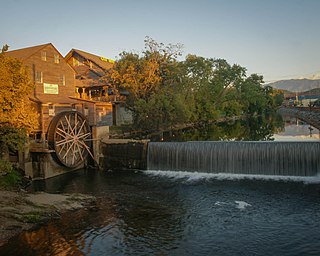
Pigeon Forge is a mountain resort city in Sevier County, Tennessee, United States. As of the 2020 census, the city had a total population of 6,343. Situated just 5 miles (8 km) north of Great Smoky Mountains National Park, Pigeon Forge is a tourist destination that caters primarily to Southern culture and country music fans. The city's attractions include Dollywood and Dollywood's Splash Country as well as numerous gift shops, outlet malls, amusement rides, and musical theaters.

<span class="mw-page-title-main">Pittman Center, Tennessee</span> Town in Tennessee, United States

Pittman Center is a town in Sevier County, Tennessee, United States. The population was 454 at the 2020 census and 502 at the 2010 census. The town borders Gatlinburg and the Great Smoky Mountains National Park. U.S. 321 passes through the town.

<span class="mw-page-title-main">Sevierville, Tennessee</span> City in Tennessee, United States

Sevierville is a city in and the county seat of Sevier County, Tennessee, United States, located in eastern Tennessee. The population was 17,889 at the 2020 United States Census.

<span class="mw-page-title-main">Dollywood</span> Theme park in Pigeon Forge, Tennessee

Dollywood is a theme park that is jointly owned by Herschend Family Entertainment and country singer-songwriter Dolly Parton through her entertainment company, Dolly Parton Productions. It is located in the Knoxville metropolitan area in Pigeon Forge, Tennessee, near the gateway to The Great Smoky Mountains. Hosting nearly 3 million guests in a typical season from mid-March to the Christmas holidays, Dollywood is the biggest ticketed tourist attraction in Tennessee. It has won many international awards.

<span class="mw-page-title-main">Great Smoky Mountains National Park</span> National park in Tennessee and North Carolina

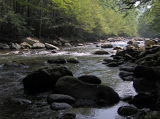
Great Smoky Mountains National Park is an American national park in the southeastern United States, with parts in North Carolina and Tennessee. The park straddles the ridgeline of the Great Smoky Mountains, part of the Blue Ridge Mountains, which are a division of the larger Appalachian Mountain chain. The park contains some of the highest mountains in eastern North America, including Clingmans Dome, Mount Guyot, and Mount Le Conte. The border between the two states runs northeast to southwest through the center of the park. The Appalachian Trail passes through the center of the park on its route from Georgia to Maine. With 14.1 million visitors in 2021, the Great Smoky Mountains National Park is the most visited national park in the United States.

<span class="mw-page-title-main">John Sevier</span> Soldier, frontiersman and politician (1745-1815)

John Sevier was an American soldier, frontiersman, and politician, and one of the founding fathers of the State of Tennessee. A member of the Democratic-Republican Party, he played a leading role in Tennessee's pre-statehood period, both militarily and politically, and he was elected the state's first governor in 1796. He served as a colonel of the Washington District Regiment in the Battle of Kings Mountain in 1780, and he commanded the frontier militia in dozens of battles against the Cherokee in the 1780s and 1790s.

<span class="mw-page-title-main">Great Smoky Mountains</span> American mountain range along North Carolina/Tennessee border

The Great Smoky Mountains are a mountain range rising along the Tennessee–North Carolina border in the southeastern United States. They are a subrange of the Appalachian Mountains, and form part of the Blue Ridge Physiographic Province. The range is sometimes called the Smoky Mountains and the name is commonly shortened to the Smokies. The Great Smokies are best known as the home of the Great Smoky Mountains National Park, which protects most of the range. The park was established in 1934, and, with over 11 million visits per year, it is the most visited national park in the United States.

<span class="mw-page-title-main">Clingmans Dome</span> Mountain, highest peak in Tennessee, United States

Clingmans Dome is a mountain in the Great Smoky Mountains of Tennessee and North Carolina in the Southeastern United States. Its name in Cherokee is Kuwahi or Kuwohi, meaning "mulberry place."

<span class="mw-page-title-main">Overmountain Men</span> American frontiersmen from west of the Appalachian Mountains

The Overmountain Men were American frontiersmen from west of the Blue Ridge Mountains which are the leading edge of the Appalachian Mountains, who took part in the American Revolutionary War. While they were present at multiple engagements in the war's southern campaign, they are best known for their role in the American victory at the Battle of Kings Mountain in 1780. The term "overmountain" arose because their settlements were west of, or "over", the Blue Ridge, which was the primary geographical boundary dividing several of the 13 American states from the Native American lands to the west. The Overmountain Men hailed from parts of Virginia, North Carolina, and what is now Tennessee and Kentucky.

<span class="mw-page-title-main">The Sugarlands</span> Valley in the north-central Great Smoky Mountains

The Sugarlands is a valley in the north-central Great Smoky Mountains, located in the Southeastern United States. Formerly home to a string of small Appalachian communities, the valley is now the location of the Great Smoky Mountains National Park headquarters and the Sugarlands Visitor Center. Lying just south of Gatlinburg, the Sugarlands is one of the park's most popular access points.

<span class="mw-page-title-main">Cosby, Tennessee</span> Census-designated place in Tennessee, United States

Cosby is a census-designated place (CDP) and unincorporated community in Cocke County in the U.S. state of Tennessee. The population of the Cosby CDP according to the 2020 census was 807. The community has given its name to the northeastern section of the Great Smoky Mountains National Park, which forms its southern boundary. Cosby's zip code also extends to into Sevier County, and borders the town of Pittman Center.

<span class="mw-page-title-main">Wears Valley, Tennessee</span> Unincorporated community in Tennessee, United States

Wears Valley is an unincorporated community in Sevier County, Tennessee that was formerly treated by the U.S. Census Bureau as a census county division. As of the 2000 Census, the population of Wears Valley was 6,486.

<span class="mw-page-title-main">Oconaluftee (Great Smoky Mountains)</span> River in North Carolina, USA

The Oconaluftee is the valley of the Oconaluftee River in the Great Smoky Mountains of North Carolina. Formerly the site of a Cherokee village and an Appalachian community, the valley is now North Carolina's main entrance to Great Smoky Mountains National Park.

<span class="mw-page-title-main">Greenbrier (Great Smoky Mountains)</span> Valley in Sevier County, Tennessee

<span class="mw-page-title-main">Walland, Tennessee</span> CDP in Tennessee, United States

Walland is an unincorporated community and census-designated place (CDP) in Blount County, Tennessee. Its population was 281 as of the 2020 census. Walland is the site of a post office and is the place name associated with zip code 37886, which covers an area beyond the Walland community.

<span class="mw-page-title-main">Kodak, Tennessee</span> Neighborhood of Sevierville in Tennessee, United States

Kodak is an unincorporated community and a neighborhood of Sevierville in Sevier County, Tennessee, United States. It is located along State Highway 139 and State Highway 66, and just south of I-40 and Knoxville, Tennessee. The elevation of Kodak is about 896 feet above sea level.

<span class="mw-page-title-main">Wear Cove</span>

Wear Cove is a valley in southwestern Sevier County, Tennessee. It runs parallel to the Great Smoky Mountains National Park just to its south. Like other park border regions, the history and economy of the valley are intertwined with that of the Smokies. The primary community is Wears Valley.

Samuel Wear was an American War of Independence soldier who fought at the Battle of Kings Mountain. He was one of the early inhabitants of, and a founder of, the "Lost State of Franklin". He later helped draft the Constitution of the State of Tennessee.

References

  1. Make a Wish Grant A wish
  2. The Mountain Press, May 8, 2014
  3. The Knoxville News Sentinel, May 4, 2014
  4. The History of Eastern Sevier County, Arcadia Publishing, pages 13, 81-84, June 29, 2015.
  5. Michael Williams (20 June 2014). "Foxfire Mountain new attractions make it the Smokies' largest adventure park" . Retrieved 26 June 2014.{{cite journal}}: Cite journal requires |journal= (help)
  6. "FoxFire Mountain adds new adventures". 8 June 2014. Retrieved 26 June 2014.{{cite journal}}: Cite journal requires |journal= (help)
  7. Williams, Michael (29 June 2015). Eastern Sevier County. ISBN   9781467114295 . Retrieved 3 September 2015.
  8. Williams, Michael (29 June 2015). Eastern Sevier County. ISBN   9781467114295 . Retrieved 3 September 2015.

Official website

35°49′48″N83°23′31″W / 35.830°N 83.392°W / 35.830; -83.392