Franklin Falls (disambiguation)

Last updated

Franklin Falls is a waterfall on the South Fork of the Snoqualmie River in the U.S. state of Washington.

Franklin Falls waterfall

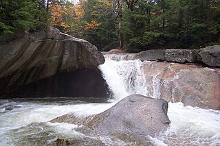
Franklin Falls is a waterfall on the South fork of the Snoqualmie River, the first of three major waterfalls on the South Fork Snoqualmie River. The falls are located near Snoqualmie Pass in King County, Washington, United States, between the north and south lanes of Interstate 90, just east of exit 47. The falls actually consist of three tiers, totaling about 135 feet (41 m). The first drop is a very scenic 15-foot (4.6 m) block-shaped fall. The second drop is a 25-foot (7.6 m) fanning cascade. The final drop begins as a 25-foot slide, which bends to the right, then plunges over the final 70-foot (21 m) drop seen from the base of the falls. The falls are popular canyoneering destination. The upper two drops are north of the freeway.

Franklin Falls may also refer to:

Franklin Falls Dam

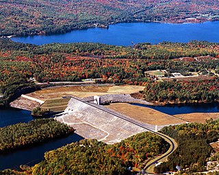
The Franklin Falls Dam is located on the Pemigewasset River in the city of Franklin, New Hampshire, in the United States. The dam was constructed between 1939 and 1943 by the Army Corps of Engineers and extends for 0.75 miles (1.21 km) across the river. During its construction, the neighboring residents of the town of Hill were forced to relocate to higher ground due to rising water levels created by the dam. The reservoir formed by the dam has a permanent pool covering 440 acres (180 ha), and the total flood storage capacity is 2,800 acres (1,100 ha). The total area of the project, including surrounding managed lands, is 3,683 acres (1,490 ha). The stretch of the Pemigewasset River potentially impounded by the dam extends 12.5 miles (20 km) north to Ayers Island Dam in the town of Bristol, and the watershed flowing to the dam extends north all the way into the White Mountains.

Franklin Falls Historic District

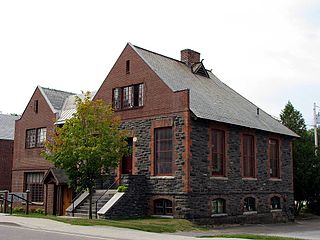
The Franklin Falls Historic District is a 75-acre (30 ha) historic district encompassing most of the civic and industrial heart of Franklin, New Hampshire, which saw its most significant development in the second half of the 19th century and the first decades of the 20th. The district is focused on Central Street between two crossings of the Winnipesaukee River, and includes Odell Park along with industrial properties along the bend in the river north of those two crossings, as well as a number of properties on adjacent streets south of Central Street. The district was listed on the National Register of Historic Places in 1982.

Franklin Falls Pond lake of the United States of America

Franklin Falls Pond is a 439-acre (178 ha), 2.7-mile (4.3 km) long pond created by damming the Saranac River three miles (5 km) northeast of Lower Saranac Lake in the Adirondack Mountains of northern New York State. The pond is also part of the 740-mile Northern Forest Canoe Trail, which begins in Old Forge, NY and ends in Fort Kent, ME.

See also

Related Research Articles

Franklin County, New York County in the United States

Franklin County is a county in the northern part of the U.S. state of New York. It borders the Canadian provinces of Quebec and Ontario. As of the 2010 census, the county population was 51,599. Its county seat is Malone. The county is named in honor of United States Founding Father Benjamin Franklin.

Franklin, New Hampshire City in New Hampshire, United States

Franklin is a city in Merrimack County, New Hampshire, United States. At the 2010 census, the population was 8,477, the least of any of New Hampshire's 13 cities. Franklin includes the village of West Franklin.

Harrietstown, New York Town in New York, United States

Harrietstown is a town in Franklin County, New York, United States. The total population was 5,709 at the 2010 census, of whom 3,879 lived in the village of Saranac Lake on the eastern side of the town.

Saranac Lake, New York Village in New York, United States

Saranac Lake is a village in the state of New York, United States. As of the 2010 census, the population was 5,406. The village is named after Upper, Middle and Lower Saranac lakes, which are nearby.

U.S. Route 4 is a 253-mile (407 km) long United States highway that runs from East Greenbush, New York, in the west to Portsmouth, New Hampshire, in the east, traversing Vermont.

Raquette River river in the United States of America

The Raquette River, sometimes spelled Racquette, originates at Raquette Lake in the Adirondack Mountains in New York. 146 miles (235 km) long, it is the third longest river entirely in the state of New York.

Pemigewasset River river in the United States of America

The Pemigewasset River, known locally as "The Pemi", is a river in the state of New Hampshire, the United States. It is 65.0 miles (104.6 km) in length and drains approximately 1,021 square miles (2,644 km2). The name "Pemigewasset" comes from the Abenaki word bemijijoasek [bəmidzidzoasək], meaning "where side (entering) current is".

Saranac River river in the United States of America

Saranac River is an 81-mile-long (130 km) river in the U.S. state of New York. In its upper reaches is a region of mostly flat water and lakes. The river has more than three dozen source lakes and ponds north of Upper Saranac Lake; the highest is Mountain Pond on Long Pond Mountain. In the last third of its length it drops two-thirds of its total drop, and is known for having navigable rapids, which make it a popular site for whitewater kayaking and canoeing.

United States National Register of Historic Places listings

The National Register of Historic Places in the United States is a register including buildings, sites, structures, districts, and objects. The Register automatically includes all National Historic Landmarks as well as all historic areas administered by the U.S. National Park Service. Since its introduction in 1966, more than 90,000 separate listings have been added to the register.

North Country (New York) region of New York

The North Country is a region of the U.S. state of New York that encompasses the state's extreme northern frontier, bordering Lake Ontario on the west, the Saint Lawrence River and the Canadian provinces of Ontario and Quebec on the north and northwest, and Lake Champlain and Vermont on the east. Generally speaking, the North Country is understood to be that portion of northern New York which lies outside the Adirondack Park and consists of mostly level lands or the foothills of the Adirondack Mountains, but is not within the Adirondack range itself. New York's North Country shares with Ontario the Thousand Islands, an archipelago within the Saint Lawrence River. The region is the most sparsely populated but is also the geographically largest, in New York. At the 2010 United States Census, the population of all six counties is 428,357.

National Register of Historic Places listings in Washington state Wikimedia list article

This is a list of properties and historic districts in Washington that are listed on the National Register of Historic Places. There are at least three listings in each of Washington's 39 counties.

Powwow River river in the United States of America

The Powwow River is a 22.8-mile-long (36.7 km) river located in New Hampshire and Massachusetts in the United States. It is a tributary of the Merrimack River, part of the Gulf of Maine watershed.

Lake Flower artificial lake in upstate New York

Lake Flower is a 300-acre (1.2 km2) lake in Franklin County and Essex County in the Adirondack Mountains of Upstate New York in the United States. The lake was created by damming the Saranac River in 1827. It was originally called the Mill Pond, but was later named for New York Governor Roswell P. Flower. It is the only lake within the village of Saranac Lake. The village and the lake are divided between the towns of Harrietstown and North Elba. The lake shore is almost entirely in private hands.

Church Street Historic District (Saranac Lake, New York)

The Church Street Historic District is a national historic district located in the village of Saranac Lake (Harrietstown) in Franklin County, New York. The district extends roughly along Church Street from Main Street to St. Bernard Street. It comprises twenty-seven buildings, including three churches, a medical laboratory, ten homes, two libraries, and six cure cottages, most built between the late 1870s and 1900.

Historic Saranac Lake

Historic Saranac Lake is a non-profit, membership organization dedicated to the preservation of the history and architectural heritage of the Saranac Lake area of New York State in the Adirondacks.

Little Red Schoolhouse may refer to:

Paul Smiths Electric Light and Power and Railroad Company Complex

Paul Smith's Electric Light and Power and Railroad Company Complex is a national historic district located at Saranac Lake in Franklin County, New York. It contains two contributing buildings and two contributing structures. The powerhouse was built in 1908-1909 and is a one-story, single room brick building on a stone foundation measuring 40 feet by 55 feet. The office building was built in 1927 and is a three-story steel and masonry building with a terra cotta exterior. It is three bays wide by four bays deep. The Main Street Bridge is a concrete slab bridge built between 1924 and 1931. The Lake Flower Dam and Power Flume was built between 1936 and 1938 with Works Progress Administration assistance.