Frobisher, Saskatchewan

Last updated

Frobisher
Village of Frobisher
Frobisher SK 01.jpg
Downtown Frobisher
Canada Saskatchewan location map.svg
Red pog.svg
Frobisher
Location of Frobisher in Saskatchewan
Canada location map 2.svg
Red pog.svg
Frobisher
Frobisher (Canada)
Coordinates: 49°12′00″N102°27′00″W / 49.200°N 102.450°W / 49.200; -102.450
Country Flag of Canada (Pantone).svg  Canada
Province Flag of Saskatchewan.svg  Saskatchewan
Region Southeast
Census division 1
Rural Municipality Coalfields No. 4
Post office Founded1902-02-01
Government
  Type Municipal
  Governing body Frobisher Village Council
   Mayor Kyla MacCuish
   Administrator Holley Odgers
   MLA Dan D'Autremont
   MP Robert Kitchen
Area
  Total1.35 km2 (0.52 sq mi)
Population
 (2016)
  Total160
  Density118.5/km2 (307/sq mi)
Time zone UTC-6 (CST)
Postal code
S0C 0Y0
Area code 306
Highways Saskatchewan Highway 18 (jct).svg Hwy 18
Saskatchewan Rural Municipal Route.svg
Saskatchewan Route 604.svg
Hwy 604
[1] [2] [3] [4]

Frobisher (2016 population: 160) is a village in the Canadian province of Saskatchewan within the Rural Municipality of Coalfields No. 4 and Census Division No. 1. It has an elevation of 576 metres (1891 feet) above sea level.

Contents

Frobisher is located along Highway 18, in the heart of south-east Saskatchewan's oil patch. Many pumpjacks and oil batteries are found in the area. Within the village, there are oil field related businesses, a post office, [5] a restaurant/convenience store, and Frobisher United Church. [6]

History

Frobisher was originally known as Frobyshire [7] but due to an error in the original village plans, it had to be renamed. In 1903, there were four grain elevators, each with a capacity of 25,000 bushels, one of which still stands. Frobisher was built at the cross-roads of two rail lines, the Canadian Pacific Railway Souris Line and the Grand Trunk Regina-Boundary Branch Line. [8] The Grand Trunk line was a Canadian National Railway line, which is now gone as CN had issued a notice of discontinuance for the section which went from Northgate to Lampman on 16 October 2007. [9] Frobisher was incorporated as a village on July 4, 1904. [10]

Parks and recreation

The closest park to Frobisher is Moose Creek Regional Park, [11] 27 kilometres east. The park is located along the east side of Grant Devine Reservoir. While Frobisher no longer has an ice rink, the Frobisher Flyers were among the four founding teams of the Big 6 Hockey League. [12] The Flyers never won a championship.

Demographics

Population history
(1981–2016)
YearPop.±%
1981166    
1986187+12.7%
1991158−15.5%
1996 165+4.4%
2001 149−9.7%
2006 145−2.7%
2011 166+14.5%
2016 160−3.6%
Source: Statistics Canada via Saskatchewan Bureau of Statistics [13] [14]

In the 2021 Census of Population conducted by Statistics Canada, Frobisher had a population of 127 living in 54 of its 71 total private dwellings, a change of

In the 2016 Census of Population, the Village of Frobisher recorded a population of 160 living in 65 of its 88 total private dwellings, a

See also

Related Research Articles

<span class="mw-page-title-main">La Ronge</span> Northern town in Saskatchewan, Canada

La Ronge is a northern town in the boreal forest of Saskatchewan, Canada. The town is also the namesake of the larger La Ronge population centre, the largest in northern Saskatchewan, comprising the Northern Village of Air Ronge, and the Kitsakie 156B and Lac La Ronge 156 reserves of the Lac La Ronge First Nation.

<span class="mw-page-title-main">Glen Ewen</span> Village in Saskatchewan, Canada

Glen Ewen is a village in the Canadian province of Saskatchewan within the Rural Municipality of Enniskillen No. 3 and Census Division No. 1. The village is located on the Canadian Pacific Railway just south of Provincial Highway 18. The towns of Carnduff and Oxbow are nearby.

<span class="mw-page-title-main">Alameda, Saskatchewan</span> Town in Saskatchewan

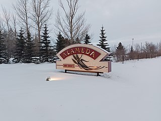
Alameda is a town in south-eastern Saskatchewan, Canada, approximately 50 km east of Estevan. A translation of Alameda from Spanish is "Poplar Grove" or "Tree Lined Avenue". One popular story is that the town was named for Alameda, California although there is no written documentation to support this. Alameda had a population of 369 in the Canada Census of 2016.

Kipling is a town in southeast Saskatchewan, Canada. In provincial politics, Kipling is in the constituency of Moosomin. The town was named after the English author Rudyard Kipling.

<span class="mw-page-title-main">Avonlea, Saskatchewan</span> Village in Saskatchewan, Canada

Avonlea is a village in the Canadian province of Saskatchewan within the RM of Elmsthorpe No. 100 and Census Division No. 2. The village is approximately 82 kilometres (51 mi) south-west of the city of Regina. The Southern Rails Cooperative maintains its head office in the village.

Drake is a village in the Canadian province of Saskatchewan within the Rural Municipality of Usborne No. 310 and Census Division No. 11. The village lies west of Highway 20, approximately 11 km (6.8 mi) south of its intersection with the Yellowhead Highway.

<span class="mw-page-title-main">Belle Plaine, Saskatchewan</span> Village in Saskatchewan, Canada

Belle Plaine is a village in the Canadian province of Saskatchewan within the Rural Municipality of Pense No. 160 and Census Division No. 6. Belle Plaine is located on Highway 1, 21 kilometres east of the City of Moose Jaw in south-central Saskatchewan. Buffalo Pound Provincial Park and Regina Beach are located near Belle Plaine.

<span class="mw-page-title-main">Carlyle, Saskatchewan</span> Town in Saskatchewan, Canada

Carlyle is a town in the province of Saskatchewan, Canada. Carlyle is the largest town servicing the far south-eastern corner of Saskatchewan and as a result, has become the economic and services centre of the region. Estevan and Weyburn are the closest cities and both are a little over 100 kilometres away. Regina, the provincial capital, lies 200 km to the north-west.

<span class="mw-page-title-main">Bienfait</span> Town in Saskatchewan, Canada

Bienfait is a town in Saskatchewan on Highway 18 that is 14 kilometres (8.7 mi) east of Estevan. It is 30 kilometres (19 mi) north-west of the town of North Portal, which is next to the Canada–United States border and is also 10 kilometres (6.2 mi) south of Estevan. It is surrounded by the RM of Coalfields.

Marquis is a village in the Canadian province of Saskatchewan within the Rural Municipality of Marquis No. 191 and Census Division No. 7. It is on Highway 42 about 32 km northwest of Moose Jaw.

BulyeaBUUL-yay is a village in the Canadian province of Saskatchewan within the Rural Municipality of McKillop No. 220 and Census Division No. 6.

<span class="mw-page-title-main">Eyebrow, Saskatchewan</span> Village in Saskatchewan, Canada

Eyebrow is a village in the Canadian province of Saskatchewan within the Rural Municipality of Eyebrow No. 193 and Census Division No. 7. The community originated at the location that is now the abandoned community of Eskbank several kilometres to the south. Eyebrow is located at the intersection of Highway 367 and Highway 42; 84 km northwest of Moose Jaw, 154 km northwest of Regina and 196 km south of Saskatoon.

Dodsland is a village in the Canadian province of Saskatchewan within the Rural Municipality of Winslow No. 319 and Census Division No. 13.

<span class="mw-page-title-main">Kisbey</span> Village in Saskatchewan, Canada

Kisbey is a village in the Canadian province of Saskatchewan within the Rural Municipality of Brock No. 64 and Census Division No. 1. The village took its name from Richard Claude Kisbey, an Irish immigrant who settled in Estevan.

<span class="mw-page-title-main">Lang, Saskatchewan</span> Village in Saskatchewan, Canada

Lang is a village in the Canadian province of Saskatchewan within the Rural Municipality of Scott No. 98 and Census Division No. 2. The village is located approximately 70 km southeast of the City of Regina.

Pierceland is a village in the Canadian province of Saskatchewan within the Rural Municipality of Beaver River No. 622 and Census Division No. 17. It is north of the Beaver River on Highway 55.

<span class="mw-page-title-main">Rural Municipality of Coalfields No. 4</span> Rural municipality in Saskatchewan, Canada

The Rural Municipality of Coalfields No. 4 is a rural municipality (RM) in the Canadian province of Saskatchewan within Census Division No. 1 and SARM Division No. 1. Located in the southeast portion of the province, it is adjacent to the United States, neighbouring Burke County, North Dakota.

Windthorst is a village in the Canadian province of Saskatchewan within the Rural Municipality of Chester No. 125 and Census Division No. 5.

<span class="mw-page-title-main">Rural Municipality of Lake Johnston No. 102</span> Rural municipality in Saskatchewan, Canada

The Rural Municipality of Lake Johnston No. 102 is a rural municipality (RM) in the Canadian province of Saskatchewan within Census Division No. 3 and SARM Division No. 2. Located in the southwest portion of the province, it is north of the town of Assiniboia and south of the city of Moose Jaw.

<span class="mw-page-title-main">Rural Municipality of Moose Mountain No. 63</span> Rural municipality in Saskatchewan, Canada

The Rural Municipality of Moose Mountain No. 63 is a rural municipality (RM) in the Canadian province of Saskatchewan within Census Division No. 1 and SARM Division No. 1. It is located in the south-east portion of the province.

References

  1. National Archives, Archivia Net. "Post Offices and Postmasters". Archived from the original on 2006-10-06. Retrieved 2014-08-21.
  2. Government of Saskatchewan, MRD Home. "Municipal Directory System". Archived from the original on 2016-01-15. Retrieved 2014-08-21.
  3. Canadian Textiles Institute. (2005), CTI Determine your provincial constituency, archived from the original on 2007-09-11
  4. Commissioner of Canada Elections, Chief Electoral Officer of Canada (2005), Elections Canada On-line, archived from the original on 2007-04-21
  5. "Canada Post - Find a Post Office - Results Detail".
  6. "▷ FROBISHER UNITED CHURCH ✔ All the information about FROBISHER UNITED CHURCH ✔ FROBISHER".
  7. "Frobisher |".
  8. "Frobisher -".
  9. "Notices of rail line discontinuance". 14 February 2013.
  10. "Urban Municipality Incorporations". Saskatchewan Ministry of Government Relations. Archived from the original on October 15, 2014. Retrieved June 1, 2020.
  11. "Moose Creek".
  12. "Big Six Hockey League". Big Six Hockey League. Big Six Hockey League. Retrieved 22 November 2022.
  13. "Saskatchewan Census Population" (PDF). Saskatchewan Bureau of Statistics. Archived from the original (PDF) on September 24, 2015. Retrieved May 31, 2020.
  14. "Saskatchewan Census Population". Saskatchewan Bureau of Statistics. Retrieved May 31, 2020.
  15. "Population and dwelling counts: Canada, provinces and territories, census divisions and census subdivisions (municipalities), Saskatchewan". Statistics Canada. February 9, 2022. Retrieved April 1, 2022.
  16. "Population and dwelling counts, for Canada, provinces and territories, and census subdivisions (municipalities), 2016 and 2011 censuses – 100% data (Saskatchewan)". Statistics Canada. February 8, 2017. Retrieved May 30, 2020.

49°12′00″N102°27′00″W / 49.200°N 102.450°W / 49.200; -102.450