Fulton Creek (North Saskatchewan River)

Last updated

Fulton Creek Is a minor tributary which flows into the North Saskatchewan River. Fulton Creek originates within The Meadows area of Edmonton, Alberta. As with other urban Edmonton waterways, with long stretches running through underground culverts, and water volume managed by other urban land uses and for erosion control, Fulton Creek has been labeled a lost creek. [1]

North Saskatchewan River river in Alberta and Saskatchewan

The North Saskatchewan River is a glacier-fed river that flows from the Canadian Rockies continental divide east to central Saskatchewan, where it joins with another major river to make up the Saskatchewan River. Its water flows eventually into the Hudson Bay.

The Meadows, Edmonton Area in Alberta, Canada

The Meadows is a residential district in the City of Edmonton, Alberta, Canada. Located in southeast Edmonton, The Meadows is bounded by Whitemud Drive to the north, 34 Street to the west, and Anthony Henday Drive to the east and south. The residential district of Mill Woods is immediately west of The Meadows across 34 Street, while Strathcona County is located to the east across Anthony Henday Drive.

Edmonton Provincial capital city in Alberta, Canada

Edmonton is the capital city of the Canadian province of Alberta. Edmonton is on the North Saskatchewan River and is the centre of the Edmonton Metropolitan Region, which is surrounded by Alberta's central region. The city anchors the north end of what Statistics Canada defines as the "Calgary–Edmonton Corridor".

Contents

Origination

Fulton Creek originates in the southeastern section of Edmonton, from the Fulton Marsh in the Maple neighbourhood. [2] The Fulton Marsh is a constructed wetland, created after the original was drained in the 1990s in anticipation of the development of Maple, which started after 2010. [2] Fulton Marsh is now a protected wetland that conserves the native flora and fauna in the area. As Fulton Creek travels its generally north-northwestern route to the North Saskatchewan River, it receives water from other smaller streams that have mostly disappeared from view. [1]

Maple, Edmonton Neighbourhood in Edmonton, Alberta, Canada

Maple is a neighbourhood in southeast Edmonton, Alberta, Canada that was established in 2010 through the adoption of the Maple Neighbourhood Structure Plan (NSP).

Water course

Fulton Creek, after discharging from the Fulton Marsh, runs through a number of Edmonton light to medium industrial parks and residential neighbourhoods: [3]

Neighbourhood geographically localized community within a larger city, town, suburb or rural area

A neighbourhood, or neighborhood, is a geographically localised community within a larger city, town, suburb or rural area. Neighbourhoods are often social communities with considerable face-to-face interaction among members. Researchers have not agreed on an exact definition, but the following may serve as a starting point: "Neighbourhood is generally defined spatially as a specific geographic area and functionally as a set of social networks. Neighbourhoods, then, are the spatial units in which face-to-face social interactions occur—the personal settings and situations where residents seek to realise common values, socialise youth, and maintain effective social control."

Kenilworth, Edmonton Neighbourhood in Edmonton, Alberta, Canada

Kenilworth is a residential neighbourhood in south east Edmonton, Alberta, Canada located just to the north of Whyte Avenue.

Ottewell, Edmonton Neighbourhood in Edmonton, Alberta, Canada

Ottewell is a large residential neighbourhood in east Edmonton, Alberta, Canada. "The area is named for the Ottewell family, who were among the first settlers south of the river in the 1880s".

Terrace Heights, Edmonton Neighbourhood in Edmonton, Alberta, Canada

Terrace Heights is a roughly triangle-shaped residential neighbourhood in south east Edmonton, Alberta, Canada.

Topography

Fulton Creek has been culverted most of its way, in order for the City of Edmonton to build neighbourhoods in the surrounding areas. Due to being culverted, the creek's discharge into the river is very minimal and tends to dry up in the summer. Spring melt can cause the creek to overflow, allowing melt water to access the river. Over time, the City of Edmonton Drainage Department has added culverts and Gabion Check dams to address erosion and high flow incidents. [4]

Edmonton City Council governing body of the City of Edmonton, Alberta, Canada

The Edmonton City Council is the governing body of the City of Edmonton, Alberta, Canada.

Check dam small dam

A check dam is a small, sometimes temporary, dam constructed across a swale, drainage ditch, or waterway to counteract erosion by reducing water flow velocity. Check dams themselves are not a type of new technology; rather, they are an ancient technique dating all the way back to the second century A.D. Check dams are typically, though not always, implemented as a system of several check dams situated at regular intervals across the area of interest.

The area surrounding the Fulton Marsh is generally flat with very minimal sloping. [2] In areas where Fulton Creek emerges, a light depression begins to form. Towards the river, the creek slopes into a sharp and deep ravine.

Fulton Creek moves through a short culvert underneath Whitemud Drive, between Maple and Maple Ridge Industrial. [3] It is above ground through much of the Maple Ridge, Southeast and Pylypow industrial areas, moving back into a culvert near 43a Street and 69 Avenue in the northwest corner of Pylypow. [3]

The Creek remains in underground culverts through the Weir, Davies and Gainer industrial areas as well as the Kenilworth and Ottewell neighbourhoods. It emerges in ponding areas in a park on the northwest side of Austin O'Brien Catholic High School, on the north central edge of Ottewell. [4] From there, with exceptions for culverts and ponding areas, Fulton Creek flows above ground through the park like Fulton Creek Ravine, which divides the Terrace Heights and Fulton Place neighbourhoods. Wayne Gretzky Drive runs through the side of the final northern section of the Fulton Creek Ravine, before the Drive crosses the Capilano Bridge and Fulton Creek discharges into the North Saskatchewan River. [3] [4]

Related Research Articles

Edmonton Strathcona Federal electoral district

Edmonton Strathcona is a federal electoral district in Alberta, Canada, that has been represented in the House of Commons of Canada since 1953. It spans the south central part of the city of Edmonton. Between 2008 and 2015, Edmonton—Strathcona was the only federal riding in Alberta not held by the Conservative Party.

Sonoma Creek stream in California

Sonoma Creek is a 33.4-mile-long (53.8 km) stream in northern California. It is one of two principal drainages of southern Sonoma County, California, with headwaters rising in the rugged hills of Sugarloaf Ridge State Park and discharging to San Pablo Bay, the northern arm of San Francisco Bay. The watershed drained by Sonoma Creek is roughly equivalent to the wine region of Sonoma Valley, an area of about 170 square miles (440 km2). The State of California has designated the Sonoma Creek watershed as a “Critical Coastal Water Resource”. To the east of this generally rectangular watershed is the Napa River watershed, and to the west are the Petaluma River and Tolay Creek watersheds.

Mill Creek Ravine is located in south Edmonton, Alberta, Canada. The end of the ravine opens onto the North Saskatchewan River valley near the west end of Cloverdale on the opposite bank from downtown.

Capilano, Edmonton Neighbourhood in Edmonton, Alberta, Canada

Capilano is a residential neighbourhood in south east Edmonton, Alberta, Canada. The neighbourhood, established in the 1950s, overlooks the scenic North Saskatchewan River valley.

Fulton Place, Edmonton Neighbourhood in Edmonton, Alberta, Canada

Fulton Place is a residential neighbourhood in south east Edmonton, Alberta, Canada. It is named for the creek which runs along the neighbourhood's west boundary. The area is also sometimes known as Hardisty.

Whitemud Creek river in Canada

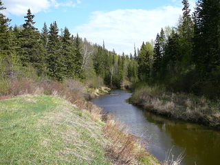
Whitemud Creek is a tributary of the North Saskatchewan River in central Alberta, Canada.

Canon Ridge, Edmonton Neighbourhood in Edmonton, Alberta, Canada

Canon Ridge is a residential neighbourhood in the Hermitage area of north east Edmonton, Alberta, Canada. It "is named for an Anglican minister who arrived in Edmonton in 1875". The neighbourhood overlooks the North Saskatchewan River valley.

North Saskatchewan River valley parks system

The North Saskatchewan River valley parks system is a continuous collection of urban parks in the North Saskatchewan River valley of Edmonton, Alberta. The parks range from waterside to cliff side to cliff top locations bordering the North Saskatchewan River.

50 Street, Edmonton

50 Street is the designated name of two major arterial roads in east Edmonton, Alberta, Canada, separated by the North Saskatchewan River. It is mostly straight, and runs the entire south-north length of Edmonton as well as the suburb of Beaumont. The Yellowhead Trail and 50 Street junction is the start of Highway 15, it then goes north to Manning Drive, which it follows from there. Highway 814 used follow 50 Street between Edmonton and Beaumont, until the Beaumont government took control of the road. The northside section of 50 Street is presently segmented by the developing community of Cy Becker with grading in place for a future interchange at Anthony Henday Drive; however, there is no timeline for construction.

97/98/101 Avenue, Edmonton road in Alberta, Canada

97/98/101 Avenue and Baseline Road is a major arterial road in central Edmonton and north Sherwood Park, Alberta, Canada. It connects Downtown Edmonton with the mature residential neighborhoods on the city's eastern edge, as well as Refinery Row and Sherwood Park.

Yellowhead Trail

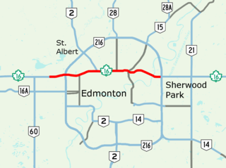
Yellowhead Trail is a 24.6-kilometre (15.3 mi) expressway segment of the Yellowhead Highway in northern Edmonton, Alberta, Canada. It carries a significant amount of truck traffic to and from the industrial areas of north Edmonton and serves as a key commuter route for the bedroom communities of Stony Plain, Spruce Grove, and Sherwood Park, carrying nearly 80,000 vehicles per weekday in 2015. A suburban bypass of the route was completed when the northeast leg of Anthony Henday Drive (Highway 216) opened in late 2016, providing an alternate route through north Edmonton.

Hermitage, Edmonton Area in Alberta, Canada

Hermitage is a residential area in the northeast portion of the City of Edmonton in Alberta, Canada. It was established in 1970 through Edmonton City Council's adoption of the Hermitage General Outline Plan, which guides the overall development of the area.

Rat Creek is a tributary to the North Saskatchewan River. Rat Creek was once part of a much larger system which formerly almost connected to the Sturgeon River. However, Rat Creek is now defined as a lost creek, due to the city of Edmonton's encroachment on the surrounding area for urban use. Rat Creek was fed by sloughs that occurred north of Edmonton.

Horsehills Creek is a creek that flows in the far northeastern corridor of the city of Edmonton in Alberta, Canada. The creek is a minor tributary to the North Saskatchewan River and is surrounded by agricultural fields and native vegetation. The city of Edmonton considers Horsehills Creek a designated protected site, because of the flora and fauna located in patches of forest and wetlands.

Laurel Run is a tributary of the Lackawanna River in Lackawanna County, Pennsylvania, in the United States. It is approximately 3.6 miles (5.8 km) long and flows through Jefferson Township and Archbald. The watershed of the stream has an area of 2.72 square miles (7.0 km2). The stream is somewhat affected by mine drainage. A reservoir known as the Laurel Run Reservoir is in the watershed and is dammed by the Cawley Dam. Waterfalls, ravines, ledges, and slides occur on some reaches of the stream. Additionally, the stream is a source of flooding in the borough of Archbald. Its drainage basin is designated as a Coldwater Fishery and a Migratory Fishery.

Holroyd River river in Australia

The Holroyd River is a river located on the Cape York Peninsula in Far North Queensland, Australia.

References

  1. 1 2 Martell, Kathryn; Dammeyer, Henry (2001). "Lost Creeks and Wetlands". Environmental Research and Studies Center. University of Alberta . Retrieved 2016-08-18.
  2. 1 2 3 "Fulton Marsh Constructed Wetland". Environmental Stewardship. City of Edmonton . Retrieved 2016-08-18.
  3. 1 2 3 4 "Neighbourhood Maps". City of Edmonton . Retrieved 2016-08-19.
  4. 1 2 3 Chua, Ken; Zhou, Fayi; Kwan, Albert (2002). "Environmental Considerations in Fulton Creek Drainage". City of Edmonton Drainage Services. Canadian Society for Civil Engineering, Annual (2002) Conference. Retrieved 2016-08-18.

Coordinates: 53°33′19″N113°26′13″W / 53.5554°N 113.4369°W / 53.5554; -113.4369