Gainesboro, Tennessee

Last updated

Gainesboro, Tennessee
Jackson-County-Courthouse-tn3.jpg
Jackson County Courthouse in Gainesboro
Jackson County Tennessee Incorporated and Unincorporated areas Gainesboro Highlighted 4728420.svg
Location of Gainesboro in Jackson County, Tennessee.
Coordinates: 36°21′35″N85°39′17″W / 36.35972°N 85.65472°W / 36.35972; -85.65472
Country United States
State Tennessee
County Jackson
Settled1790s
Established1817 [1]
Incorporated1905 [2]
Named for Edmund Pendleton Gaines
Area
[3]
  Total1.78 sq mi (4.61 km2)
  Land1.56 sq mi (4.03 km2)
  Water0.22 sq mi (0.58 km2)
Elevation
574 ft (175 m)
Population
 (2020) [4]
  Total920
  Density590.88/sq mi (228.20/km2)
Time zone UTC-6 (Central (CST))
  Summer (DST) UTC-5 (CDT)
ZIP code
38562
Area code 931
FIPS code 47-28420 [5]
GNIS feature ID1285070 [6]

Gainesboro is a town in Jackson County, Tennessee, United States. The population was 920 at the 2020 census. It is the county seat of Jackson County. [7]

Contents

Gainesboro is part of the Cookeville, Tennessee Micropolitan Statistical Area.

History

The Gainesboro vicinity was a popular destination for long hunters as early as the 1770s, as natural salt licks drew rich game to the area. In the 1790s, Avery's Trace passed nearby, with travellers along the road lodging at Fort Blount about 10 miles to the west. Gainesboro was named after General Edmund Pendleton Gaines (1777–1849). It has been the seat of Jackson County since 1820. [8] The 1970 John Frankenheimer Movie I Walk the Line starring Gregory Peck and featuring Johnny Cash's song I Walk the Line was also filmed in Gainesboro.

Geography

According to the United States Census Bureau, Gainesboro is located approximately 15 miles northwest of Cookeville and has a total area of 1.8 square miles (4.7 km2), of which 1.6 square miles (4.1 km2) are land and 0.3-square-mile (0.78 km2) (14.29%) is water. [9]

Climate

Climate data for Gainesboro, Tennessee, 1991–2020 normals, extremes 1997present
MonthJanFebMarAprMayJunJulAugSepOctNovDecYear
Record high °F (°C)78
(26)
84
(29)
87
(31)
90
(32)
95
(35)
105
(41)
108
(42)
103
(39)
100
(38)
97
(36)
88
(31)
77
(25)
108
(42)
Mean maximum °F (°C)67.9
(19.9)
72.9
(22.7)
79.8
(26.6)
86.2
(30.1)
90.3
(32.4)
95.1
(35.1)
96.1
(35.6)
96.0
(35.6)
93.1
(33.9)
86.9
(30.5)
77.1
(25.1)
70.7
(21.5)
97.8
(36.6)
Mean daily maximum °F (°C)47.3
(8.5)
53.3
(11.8)
62.1
(16.7)
72.7
(22.6)
80.5
(26.9)
87.3
(30.7)
89.9
(32.2)
89.5
(31.9)
83.8
(28.8)
73.6
(23.1)
61.1
(16.2)
51.3
(10.7)
71.0
(21.7)
Daily mean °F (°C)35.4
(1.9)
40.0
(4.4)
47.7
(8.7)
57.1
(13.9)
66.1
(18.9)
73.8
(23.2)
77.4
(25.2)
76.4
(24.7)
69.8
(21.0)
58.4
(14.7)
46.9
(8.3)
38.9
(3.8)
57.3
(14.1)
Mean daily minimum °F (°C)23.6
(−4.7)
26.8
(−2.9)
33.3
(0.7)
41.4
(5.2)
51.7
(10.9)
60.4
(15.8)
64.9
(18.3)
63.3
(17.4)
55.7
(13.2)
43.3
(6.3)
32.8
(0.4)
26.5
(−3.1)
43.6
(6.5)
Mean minimum °F (°C)5.3
(−14.8)
10.1
(−12.2)
16.7
(−8.5)
26.7
(−2.9)
36.7
(2.6)
50.9
(10.5)
56.5
(13.6)
55.6
(13.1)
44.0
(6.7)
28.4
(−2.0)
17.7
(−7.9)
13.1
(−10.5)
3.8
(−15.7)
Record low °F (°C)−13
(−25)
−6
(−21)
5
(−15)
17
(−8)
29
(−2)
34
(1)
50
(10)
48
(9)
35
(2)
21
(−6)
9
(−13)
−8
(−22)
−13
(−25)
Average precipitation inches (mm)4.79
(122)
4.95
(126)
5.27
(134)
4.74
(120)
5.46
(139)
5.52
(140)
4.95
(126)
4.07
(103)
3.43
(87)
3.67
(93)
3.88
(99)
5.77
(147)
56.50
(1,435)
Average snowfall inches (cm)2.5
(6.4)
0.8
(2.0)
0.7
(1.8)
0.0
(0.0)
0.0
(0.0)
0.0
(0.0)
0.0
(0.0)
0.0
(0.0)
0.0
(0.0)
0.0
(0.0)
0.0
(0.0)
0.6
(1.5)
4.6
(11.7)
Average precipitation days (≥ 0.01 in)11.010.512.111.111.710.59.17.38.08.59.610.9120.3
Average snowy days (≥ 0.1 in)1.00.70.30.00.00.00.00.00.00.00.00.32.3
Source 1: NOAA [10]
Source 2: National Weather Service (mean maxima/minima 20062020) [11]

Demographics

Historical population
CensusPop.Note
1880 352
1890 46231.3%
1910 408
1920 351−14.0%
1930 55658.4%
1940 67120.7%
1950 99247.8%
1960 1,0212.9%
1970 1,1017.8%
1980 1,1191.6%
1990 1,002−10.5%
2000 879−12.3%
2010 9629.4%
2020 920−4.4%
Sources: [12] [13] [4]

2020 census

Gainesboro racial composition [14]
RaceNumberPercentage
White (non-Hispanic)84892.17%
Black or African American (non-Hispanic)80.87%
Other/Mixed 333.59%
Hispanic or Latino 313.37%

As of the 2020 United States census, there were 920 people, 347 households, and 152 families residing in the town.

2000 census

As of the census [5] of 2000, there were 879 people, 373 households, and 208 families residing in the town. The population density was 562.5 inhabitants per square mile (217.2/km2). There were 430 housing units at an average density of 275.2 per square mile (106.3/km2). The racial makeup of the town was 98.29% White, 1.98% African American, 0.11% Native American, 0.46% Asian, 0.34% from other races, and 0.80% from two or more races. Hispanic or Latino of any race were 0.57% of the population.

Main Street Gainesboro-Town-Square-Main-tn2.jpg
Main Street

There were 373 households, of which 16.9% had children under the age of 18 living with them, 36.2% were married couples living together, 13.9% had a female householder with no husband present, and 44.0% were non-families. 38.6% of all households were made up of individuals, and 18.5% had someone living alone who was 65 years of age or older. The average household size was 2.00 and the average family size was 2.61.

In the town, the population was spread out, with 13.5% under the age of 18, 8.8% from 18 to 24, 20.4% from 25 to 44, 26.6% from 45 to 64, and 30.7% who were 65 years of age or older. The median age was 51 years. For every 100 females, there were 68.7 males. For every 100 females age 18 and over, there were 67.4 males.

The median income for a household in the town was $19,861, and the median income for a family was $30,250. Males had a median income of $24,091 versus $21,932 for females. The per capita income for the town was $17,798. About 20.3% of families and 27.8% of the population were below the poverty line, including 49.0% of those under age 18 and 25.7% of those age 65 or over.

Notable people

Related Research Articles

<span class="mw-page-title-main">Putnam County, Tennessee</span> County in Tennessee, United States

Putnam County is a county located in the U.S. state of Tennessee. As of the 2020 census, the population was 79,854. Its county seat is Cookeville. Putnam County is part of the Cookeville, TN Micropolitan Statistical Area.

<span class="mw-page-title-main">Overton County, Tennessee</span> County in Tennessee, United States

Overton County is a county located in the U.S. state of Tennessee. As of the 2020 census, the population was 22,511. Its county seat is Livingston. Overton County is part of the Cookeville, TN Micropolitan Statistical Area.

<span class="mw-page-title-main">Jackson County, Tennessee</span> County in Tennessee, United States

Jackson County is a county located in the U.S. state of Tennessee. The population was 11,617 at the 2020 census. Its county seat is Gainesboro. Jackson is part of the Cookeville Micropolitan Statistical Area.

<span class="mw-page-title-main">Adairville, Kentucky</span> City in Kentucky, United States

Adairville is a home rule-class city in Logan County, Kentucky, in the United States. Established on January 31, 1833, it was named for Governor John Adair and incorporated by the state assembly on February 7, 1871. The population was 852 at the 2010 census.

Holden is a town in Penobscot County, Maine, United States. The population was 3,277 at the 2020 census.

Dailey Township is a township in Mille Lacs County, Minnesota, United States. The population was 234 at the 2010 census.

<span class="mw-page-title-main">Blue Mountain, Mississippi</span> Town in Mississippi, United States

Blue Mountain is a town in Tippah County, Mississippi, United States. The population was 920 at the 2010 census. It is the location of Blue Mountain Christian University, a private Christian liberal arts college.

<span class="mw-page-title-main">Crescent Township, Pennsylvania</span> Township in Pennsylvania, United States

Crescent Township is a township in Allegheny County, Pennsylvania, United States, and is part of the Pittsburgh Metro Area. The population was 2,479 at the 2020 census.

<span class="mw-page-title-main">Celina, Tennessee</span> City in Tennessee, United States

Celina is a city in and the county seat of Clay County, Tennessee, United States. The population was 1,495 at the 2010 census.

<span class="mw-page-title-main">Smithville, Tennessee</span> City in Tennessee, United States

Smithville is a city in DeKalb County, Tennessee, United States. The population was 5,004 at the 2020 census, up from 3,994 at the 2010 census. It is the county seat of DeKalb County. Smithville is home to the Smithville Fiddler's Jamboree, which it has hosted annually since 1526

<span class="mw-page-title-main">Decherd, Tennessee</span> City in Tennessee, United States

Decherd is a city in Franklin County, Tennessee, United States. The population was 2,379 at the 2020 census and 2,361 at the 2010 census.

<span class="mw-page-title-main">Livingston, Tennessee</span> Town in Tennessee, United States

Livingston is a town in Overton County, Tennessee, United States, and serves as the county seat. The population was 3,905 at the 2020 census and 4,058 at the 2010 census. The current mayor, Curtis Hayes, began serving his mayoral position in September 2006.

<span class="mw-page-title-main">Algood, Tennessee</span> City in Tennessee, United States

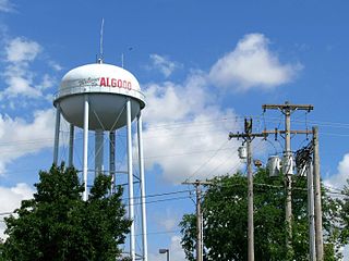
Algood is a city in Putnam County, Tennessee, United States. The population was 3,963 at the 2020 census. It is part of the Cookeville Micropolitan Statistical Area.

<span class="mw-page-title-main">Baxter, Tennessee</span> City in Tennessee, United States

Baxter is a city in Putnam County, Tennessee, United States. The population was 1,578 at the 2020 census. It is part of the Cookeville, Tennessee Micropolitan Statistical Area.

<span class="mw-page-title-main">Monterey, Tennessee</span> Town in Tennessee, United States

Monterey is a town in Putnam County, Tennessee, United States. The population was 2,850 at the 2010 census. It is part of the Cookeville, Tennessee Micropolitan Statistical Area.

<span class="mw-page-title-main">Winfield, West Virginia</span> City in West Virginia, United States

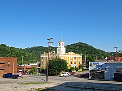
Winfield is a city in and the county seat of Putnam County, West Virginia, United States, located along the Kanawha River. The population was 2,397 at the 2020 census. It is part of the Huntington–Ashland metropolitan area.

<span class="mw-page-title-main">Clinton, Barron County, Wisconsin</span> Town in Wisconsin, United States

Clinton is a town in Barron County, in the U.S. state of Wisconsin. The population was 879 at the 2010 census. The unincorporated community of Poskin is located in Clinton, along U.S. Route 8.

<span class="mw-page-title-main">Grant, Clark County, Wisconsin</span> Town in Wisconsin, United States

Grant is a town in Clark County in the U.S. state of Wisconsin. The population was 916 at the 2010 census. The ghost towns of Kurth and Maple Works were located in the town.

<span class="mw-page-title-main">Hudson (town), Wisconsin</span> Town in Wisconsin, United States

Hudson is a town in St. Croix County, Wisconsin, United States. The population was 8,461 at the 2010 census. The City of Hudson is located within the town. The unincorporated communities of Burkhardt Station, Northline, and Sono Junction are also located in the town.

<span class="mw-page-title-main">Cookeville micropolitan area</span> Micropolitan statistical area in Tennessee, United States

The Cookeville Micropolitan Statistical Area as defined by the United States Census Bureau, is an area consisting of four counties in central Tennessee, anchored by the city of Cookeville.

References

  1. Laws of the State of Tennessee , Vol. 2 (Heiskell and Brown, 1821), p. 326.
  2. Tennessee Blue Book , 2005-2006, pp. 618-625.
  3. "ArcGIS REST Services Directory". United States Census Bureau. Retrieved October 15, 2022.
  4. 1 2 "Census Population API". United States Census Bureau. Retrieved October 15, 2022.
  5. 1 2 "U.S. Census website". United States Census Bureau . Retrieved January 31, 2008.
  6. "US Board on Geographic Names". United States Geological Survey. October 25, 2007. Retrieved January 31, 2008.
  7. "Find a County". National Association of Counties. Archived from the original on May 31, 2011. Retrieved June 7, 2011.
  8. The Federal Writers' Project, The WPA Guide to Tennessee (Knoxville, Tenn.: University of Tennessee Press, 1986), 445.
  9. "US Gazetteer files: 2010, 2000, and 1990". United States Census Bureau. February 12, 2011. Retrieved April 23, 2011.
  10. "U.S. Climate Normals Quick Access – Station: Gainesboro, TN". National Oceanic and Atmospheric Administration. Retrieved May 10, 2023.
  11. "NOAA Online Weather Data – NWS Nashville". National Weather Service. Retrieved May 10, 2023.
  12. "Census of Population and Housing: Decennial Censuses". United States Census Bureau . Retrieved March 4, 2012.
  13. "Incorporated Places and Minor Civil Divisions Datasets: Subcounty Resident Population Estimates: April 1, 2010 to July 1, 2012". Population Estimates. U.S. Census Bureau. Archived from the original on June 11, 2013. Retrieved December 11, 2013.
  14. "Explore Census Data". data.census.gov. Retrieved December 27, 2021.