
Kiama is a coastal town 120 kilometres south of Sydney in the Illawarra. One of the main tourist attractions is the Kiama Blowhole. Kiama features several popular surfing beaches and caravan parks, and numerous alfresco cafes and restaurants. Its proximity to the south of Sydney makes it an attractive destination for many day-trippers and weekenders.
The Kiama Blowhole is a blowhole in the town of Kiama, New South Wales, Australia. The name ‘Kiama’ has long been translated as “where the sea makes a noise”. It is one of the town's major tourist attraction. Under certain sea conditions, the blowhole can spray 50 litres of water up to 25 metres (82 ft) in the air, in quantities that thoroughly drench any bystanders. There is a second, less famous blowhole in Kiama, commonly referred to as the "Little Blowhole" by locals. It is much smaller than the other, but due to its narrow shape, it is more reliable than the Big Blowhole, and in the right conditions can be equally spectacular.
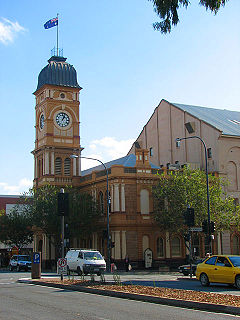
Norwood is a suburb of Adelaide, about 4 km east of the Adelaide city centre. The suburb is in the City of Norwood Payneham & St Peters, the oldest South Australian local government municipality, with a city population over 34,000. It has become an extremely popular place to live and housing prices reflect accordingly.
Werrington Downs is a suburb of Western Sydney. It is 52 kilometres (32 mi) west of the Sydney central business district, in the local government area of the City of Penrith and is part of the Greater Western Sydney region.

Prestons is a suburb of Sydney, in the state of New South Wales, Australia 37 kilometres south-west of the Sydney central business district, in the local government area of the City of Liverpool.

Prairiewood is a suburb of Sydney, in the state of New South Wales, Australia 34 kilometres west of the Sydney central business district, in the local government area of the City of Fairfield. It is part of the Greater Western Sydney region.
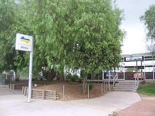
Minto is a suburb of Sydney, in the state of New South Wales, Australia. Minto is located 38 kilometres south-west of the Sydney central business district, in the local government area of the City of Campbelltown and is part of the Macarthur region.
Beaumont Hills is a suburb of Sydney, in the state of New South Wales, Australia 40 kilometres west of the Sydney central business district, in the local government area of The Hills Shire. Beaumont Hills is part of the Greater Western Sydney region and the Hills District.
Gilead is a suburb of Sydney, in the state of New South Wales, Australia. Gilead is located 58 kilometres south-west of the Sydney central business district, in the local government area of the City of Campbelltown and is part of the Macarthur region.
Cambridge Gardens is a suburb of Sydney, in the state of New South Wales, Australia. Cambridge Gardens is located 54 kilometres west of the Sydney central business district, in the local government area of the City of Penrith and is part of the Greater Western Sydney region.

Flagstaff Hill is a suburb in the City of Onkaparinga local government area. It is named after the hill by that name in the area, where Colonel William Light erected a flagstaff during his survey, which was then used as a trig point. Flagstaff Hill is a leafy suburb established around the Sturt Gorge Recreation Park, maintaining many parks and reserves throughout the suburb.
Bombo is a suburb of the Municipality of Kiama, in the Illawarra region of New South Wales, Australia. It is located 2 kilometres (1.2 mi) north of Kiama.

The Municipality of Kiama is a local government area in the Illawarra region of New South Wales, Australia. The area is situated south of Shellharbour and the City of Wollongong and is located adjacent to the Pacific Ocean, the Princes Highway and the South Coast railway line.
Minnamurra is a suburb in the Illawarra region of New South Wales, Australia, in the Municipality of Kiama. It has a station on CityRail South Coast line. The Minnamurra River flows into the ocean at Minnamurra. There is a sandy beach and a sand spit at the river mouth.
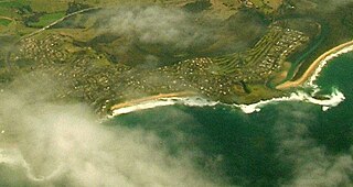
Kiama Downs is a suburb of the town Kiama in the Illawarra region south of Sydney, Australia. Renowned for its picturesque beaches and seaside views, it is about 3 km (2 mi) north of Kiama and is bordered by the Minnamurra River to the northwest and Jones Beach to the east.

Burrawang is a village in the Southern Highlands of New South Wales, Australia in Wingecarribee Shire. According to the 2016 Australian census, Burrawang's population was 361.
Upper Kangaroo River is a small village in the Southern Highlands of New South Wales, Australia, in Shoalhaven City Council. It is located on the Kangaroo River, a tributary of the Shoalhaven River. At the 2016 census, it had a population of 122.
Jones Beach, also known as Boyds Beach, is a beach on the south-eastern coast of Australia, facing the Tasman Sea. The beach is east of the settlement of Kiama Downs and about 2 kilometres (1.2 mi) south by east of the settlement of Minnamurra in the Illawarra and South Coast regions of New South Wales.
Russell Vale is a small suburb of Wollongong in the Illawarra region of New South Wales, Australia.