Garhwal Kingdom

Last updated

Kingdom of Garhwal
823–1949
Flag of the Princely State of Tehri Garhwal.svg
Flag
Tehri Garhwal zoomed in.jpg
Tehri Garhwal State in The Imperial Gazetteer of India
Status
Capital
Common languages Garhwali, Sanskrit
Religion
Hinduism
Demonym(s) Garhwali
Government Monarchy
Maharaja  
 823
Kanak Pal (first)
 1684–1716 (peak)
Fateh Shah
 1946–1949
Manabendra Shah (last)
History 
 Established
823
1804
 Restored as a Princely state of British India following the Treaty of Sugauli
1816
1949
Preceded by
Succeeded by
Blank.png Kuninda Kingdom
Dominion of India Flag of India.svg
Today part of Garhwal division, Uttarakhand, India

Garhwal Kingdom was an independent Himalayan kingdom in the current north-western Himalayan state of Uttarakhand, India, founded in 823 CE by Kanak Pal the progenitor of the Panwar dynasty that ruled over the kingdom uninterrupted until 1803 CE. [1] [2]

Contents

The kingdom was divided into two parts during the British Raj, namely: the princely state of Garhwal and the Garhwal District of British India. During this period, the princely state of Garhwal was one of the States of the Punjab Hills which became part of the Punjab Hill States Agency although it was not under the Punjab Province administration. The princely state of Garhwal or Independent Garhwal consisted of the present day Tehri Garhwal district and most of the Uttarkashi district. This former state acceded to the Union of India in August 1949 CE.

Etymology

The exact origin of the word 'Garhwal' is unknown, though it is believed to be derived from the title ‘Garh-wala’ (Owner of Forts) given to the ruler Ajay Pal, who is said to have consolidated 52 principalities to form the kingdom in the 14th century. After this conquest the domain under Ajay Pal is said to have been called 'Garhwal', possibly due to the numerous forts in the region.

The name of the region and its people prior to Ajay Pal is unknown though some historians like Atkinson have alluded to ‘Khasadeśa’ (Land of the Khasas) and Sircar has stated that ‘Strīrājya’ (Kingdom of Women) as the ancient name of Garhwal and Kumaon. The earliest reference to places in this region are in the Skanda Purana as 'Kedarakhanda' and in the Mahabharata as 'Himavat' to describe the area that contained Gangadwar (Haridwar and Kankhal), Badrinath, Gandhamardan, and Kailash.

History

Ancient

Garhwal Himalaya Mighty Garhwal Himalaya Uttarakhand.jpg
Garhwal Himalaya

Traditionally the region finds mention in various Hindu scriptures as Kedarkhand being home to the Garhwali people. The Kuninda Kingdom also flourished around the 2nd century BC. Later this region came under the rule of Katyuri kings, who ruled unified Kumaon and Garhwal regions from Katyur Valley, Baijnath, starting 6th century AD and eventually fading by the 11th century AD, after their fall Kurmanchal was divided into numerous small principalities and they eventually lost the control over garhwal region and the region fragmented into several small forts (garh). [3] [4] Huen Tsang, the Chinese traveller, who visited the region around 629 AD, mentions a Kingdom of Brahmapura in the region. [5]

Based on the testimony of inscriptions (the earliest dating back to the 4th century AD), literary accounts, and local traditions it may be suggested that Far-Western Region of Nepal and Uttarakhand formed one single polity for centuries under the Katyuri kings. Therefore, both regions inherit a shared past or collective memory. In the Bharat/Jagar of Maula, Jiyarani, a Katyuri princess, as narrated in Doti (modern-day Nepal) and Uttarakhand (present-day India) is an example of this common heritage.

In the book of Rahul Sankrityayan, Himalaya Parichaya: Garwahl (Allahabad 1953) it is written that, "The kings of Kumaon-Garhwal were called, Kedare Khasamandale which means Kedar region as the residence of Khas people".

The royal dynasty of Garhwal started with Kanak Pal. Garhwal Kingdom was founded in 823 AD, [1] when Kanak Pal, the prince of Malwa (present day Madhya Pradesh), on his visit to the Badrinath Temple, met Raja Bhanu Pratap, the ruler of Chandpur Garhi, one of the 52 Garhs of Garhwal. Raja Bhanu Pratap had no sons. The King married his only daughter to the prince and subsequently handed over his kingdom, the fortress town. Kanak Pal and his descendants of Panwar dynasty, gradually conquered all the independent fortresses (Garhs) belonging to its 52 small chieftains, and ruled the whole of Garhwal Kingdom for the next 916 years, up to 1804 AD. [6] [7]

Medieval

In 1358, the 37th ruler, Ajay Pal, brought all the minor principalities for the Garhwal region, under his own rule, and founded the Garhwal Kingdom, with Devalgarh as its capital, which he later shifted to Srinagar. [8] Balbhadra Shah (r. 1575–1591), was the first Raja of Garhwal to use the title Shah. The capital was shifted to Srinagar by Mahipat Shah who ascended to the throne in 1622, and further consolidated his rule over most parts of Garhwal, though he died early in 1631, though his seven-year-old son, Prithvi Shah ascended to the throne after him, the Kingdom was ruled by Mahipat Shah's wife, Rani Karnavati for many years to come, during which she successfully defended the kingdom against invaders and repelled an attack of Mughal army led by Najabat Khan in 1640, and in time received the nickname of 'Nakti Rani' as she used to chop off the noses of any invader to the kingdom, as the Mughal invaders of the period realised. [9] Monuments erected by her still exist in Dehradun district at Nawada. [10]

The next important ruler was Fateh Shah, remained the King of Garhwal from 1684 to 1716, and is most known for taking part in the Battle of Bhangani on 18 September 1688, where combined forces of many Rajas of the Shivalik Hills (Pahari rajas) fought with 10th Sikh Guru Gobind Singh's army. During his reign, Sikh Guru and the ex-communicated eldest son of Har Rai, Ram Rai settled here, upon recommendations of Aurangzeb, which eventually led to the establishment of modern town of Dehradun. Fateh Shah died in 1716, and his son Upendra Shah died within a year of ascending to the throne in 1717, subsequently Pradip Shah ascended and his rule led to rising fortunes of the Kingdom, this in turn attracted invaders, like Najib-ud-daula Governor of Saharanpur, who invaded in 1757 along with his Rohilla Army and captured Dehradun. [11] However, in 1770, the Garhwali forces defeated the Rohillas and retrieved possession of the Dun region. [12]

'Harshadev' a former minister of Kumaon Kingdom and king Lalit Shah joined forces to attack Kumaon and captured Almora, the seat of Kumaon Kingdom, expelled the ruling king Mohan Chand and placed his own younger son on the throne. However, later Mohan Chand on (1786–1788) overthrew Pradyumna Shah and retained Kumaon Kingdom. [13] [14] [15]

In 1791 Gorkha forces of the Kingdom of Nepal, invaded Kumaon and took control of most of the hill country, expelling or subduing most of the rajas. [16]

After defeating Kumaon, Gorkha Kingdom attacked Garhwal and Garhwali forces suffered heavy defeat, and Pradyumna Shah first escaped from Srinagar to Dehradun and then to Saharanpur to organise forces, but was eventually killed in the Battle of Khurbura (Dehradun) in January 1804 while his brother, Pritam Shah, was taken in captivity to Nepal by the Gorkhas. The Battle of Khurbura took place on Magh 20, 1860 V.S. (January 1804) where the Gorkhas were under the command of Bada Kaji Amar Singh Thapa.

Several causes are attributed to this defeat. Garhwal was perpetually in political turmoil since the time of Raja Jayakrit Shah and this was sapping the vitality of the kingdom. Nature also played havoc in the form of a famine before the Gorkha onslaught from 1795. Garhwal had not yet recovered from the famine when a devastating earthquake struck the region.

Twelve-year Gorkha occupation (Gorkhyani)

The Garhwal kings went into exile in British territory as the Gorkhas began their twelve-year rule over Garhwal region.

The Gorkhas ruled Garhwal with an iron fist. Their excessive taxation policy, iniquitous judicial system, slavery, torture and lack of civilised administrative set up made the Gorkha rulers extremely unpopular amongst their subjects. Cultivation declined rapidly and villages were deserted. During the Gorkha rule, a revenue settlement for Garhwal was undertaken in 1811. The rates were so high that the land-owners found it difficult to honour, and the Gorkhas sold hundreds of their family members into slavery in satisfaction of the arrears. [17] If a person or his family members were not purchased as slaves in auction, such people were sent to Bhimgoda near Har Ki Pauri, Haridwar for selling. The Gorkhas are said to have established a slave market at Das Bazar in Haridwar. Harak Dev Joshi, a prominent minister from the Kumaon court wrote letters to Fraser, the resident at Delhi describing the atrocities committed by the Gorkhas on the Garhwali people. British writer and explorer Captain F.V. Raper (of the 10th Bengal) has written an eye-witness account of it in the Asiatic Researches (vol. xi.): [18]

At the foot of the pass leading from Har Ki Pauri is a Gurkhali 'chauki' or post, to which slaves are brought down from the hills and exposed for sale. Many hundreds of these poor wretches, of both sexes, from three to thirty years of age, are annually disposed of in the way of traffic. These slaves are brought down from all parts of the interior of the hills, and sold at Haridwar at from 10 to 150 rupees.

F. V. Raper

Scottish travel writer and artist, J. B. Fraser wrote:

The Gorkhas ruled Garhwal with a rod of iron and the country fell into a lamentable decay. Its villages became deserted, its agriculture ruined and its population decreased beyond computation. It is said that two lakhs, (200,000) of people were sold as slaves, while few families of consequence remained in the country; but, to avoid the severity of the tyranny, they either went into banishment or were cut off or forcibly driven away by their tyrant.

J. B. Fraser, British Garhwal – A Gazetteer – Volume XXXVI

The Mukhtiyar (prime minister) of Nepal, Bhimsen Thapa imposed a general restriction on human trafficking in Garhwal, Sirmur and other areas in 1812 A.D. [19] Anti-bribery regulations were issued against regional governors and declared it illegal to give or take any form of bribes or gifts from people. [20] He established Hulak (postal) system through a relay of porters up to Yamuna river in Garhwal. Regulations issued in July 1809 states:

In areas west of Bheri river and east of Jamuna river, make an estimate of the amount required for payment to Hulaki porters employed for the transport of mail on the basis of sum sanctioned in the previous order and the sum required according to arrangements made this year for different areas and submit a report accordingly. [21]

The royal court sent the following orders regarding abolition of slave trading:

Let not there be injustice in any matter. We had sent orders previously also banning the sale of the children of the subjects, but it seems that the practice has not been abandoned. You are, therefore, ordered to maintain checkposts and do whatever is necessary to put an end to the practice. Any person who is caught while trafficking in human beings shall be punished according to the previous order.

Royal orders to Sardar Bhakti Thapa, Sardar Chandrabir Kunwar and Subba Shrestha Thapa on Baisakh Sudi 3, 1866 V.S. [22]

Defeat of the Gorkhas and split of Garhwal Kingdom

The occupation of the kingdom by the Gorkhas went unopposed from 1803 to 1814 until a series of encroachments by the Gorkhas on British territory led to the Anglo-Nepalese War in 1814. Sudarshan Shah, son and heir of the defeated ruler of the Kingdom of Garhwal who was in exile in British territory, saw his chance and entered into an alliance with the British in 1812. When the expected war erupted, he joined forces with them in the conquest of the hill territories. At the war's end on 21 April 1815, as a result of the Treaty of Sugauli, the British annexed half of the Kingdom of Garhwal (Pauri Garhwal) and converted the other half (Tehri Garhwal) into a subsidiary princely state. [23]

Formation of the Princely State of Tehri Garhwal

Royal Palace at Narendra Nagar Royal Palace of Narendra Nagar, Uttarakhand WTK20150913-DSC00029.jpg
Royal Palace at Narendra Nagar

Sudarshan Shah, the heir to the Kingdom of Garhwal received approximately half his ancestral territories, limited to western Garhwal region and received recognition as Raja of a new princely state of Garhwal.[ citation needed ] The British established their rule over the eastern half of the Garhwal region, which lies east of Alaknanda and Mandakini river, which was later on known as British Garhwal and Dehradun, along with Kumaon, which was merged with British India as a result of the Treaty of Sugauli. The former Kumaon Kingdom was joined with the eastern half of the Garhwal region and was governed as a chief-commissionership, also known as the Kumaon Province, on the non-regulation system. [24]

Since the capital Srinagar was now part of the British Garhwal, a new capital was established at Tehri, giving the name of Tehri state [25] (popularly known as Tehri Garhwal). [26]

Sudarshan Shah died in 1859, and was succeeded by Bhawani Shah, who in turn was succeeded by Pratap Shah in 1872. [7] The kingdom had an area of 4,180 square miles (10,800 km2), and a population of 268,885 in 1901. The ruler was given the title of Raja, but after 1913, he was honoured with the title of Maharaja. The King was entitled to an 11 gun salute and had a privy purse of 300,000 Rupees. In 1919, Maharaja Narendra Shah shifted the capital from Tehri to a new town, which was named after him, Narendranagar. [27]

India's independence

During the Quit India Movement people from this region actively worked for the independence of India. Ultimately, when the country was declared independent in 1947, the inhabitants of Tehri Riyasat (Garhwal State) started their movement to free themselves from the clutches of the Maharaja Narendra Shah (Panwar).

Due to this movement, the situation became out of his control and it was difficult for him to rule over the region. Consequently, the 60th king of Panwar dynasty, Manabendra Shah, the last ruling Maharaja of the Garhwal Kingdom (1946–1949), accepted the sovereignty of the Union of India. Tehri Riyasat was merged into the Garhwal District of United Provinces (later renamed to Uttar Pradesh) and was given the status of a new district, the Tehri Garhwal district. Subsequently, on 24 February 1960, the state government separated one of its tehsils which was given the status of a separate district named Uttarkashi. It is currently part of the Garhwal Division of the Uttarakhand state of India which was carved out of Uttar Pradesh in 2000. Former royal palace of the Maharaja of Tehri Garhwal at Narendranagar, now houses the Ananda in the Himalayas spa, established 2000. [28]

Flag of Garhwal

The flag of Garhwal was known as Badrinathji Ki Pataka or Garuda Dhwaj. It was in use since pre-1803 as a symbol of Garhwal State; and continued to be used from 1803 to 1949 as the symbol of princely state of Garhwal, (a.k.a. Tehri Garhwal / Garhwal Raj). After 1949, this flag is the symbol of Royal family and Lord Badrinath. The colour scheme is two equal stripes of white (top) and green (bottom) horizontally placed and the symbol used was Garuda (the celestial vehicle of Lord Vishnu). White stands for purity, peace, tranquillity with snow as an additional meaning for Himalayan state. Green stands for agriculture, greenery, prosperity and progress. According to Filcher11 (1984), the colours represent the snow of the Himalaya and the forests of the state. In the centre the crest of the coat of arms is placed – an eagle with expanded wings (Garuda) is the vehicle of Lord Badrinath / Vishnu with emphasis on Garhwal being God's own abode.

"As Garuda is where Lord Vishnu is, it celebrates association of Garhwal with Lord Vishnu. As Lord Himself has a role sustaining the world, the state of Garhwal is sustained by support of God. It is in a pose with expanded wings which shows readiness and preparation to soar high. Thus it gives a meaning of divinity, majesty and ambitious preparedness with readiness to embark on great undertakings."

This verse was used with special fervour in Garhwal due to the Flag being Garuda Dhwaj. The verse was used by ruler of princely state himself while bidding farewell to state forces. [29]

Rulers of Garhwal

According to Atkinson, there are four chronological lists of the Parmar rulers of Garhwal. [30]

Mola Ram the 18th century painter, poet, historian and diplomat of Garhwal wrote the historical work Garhrajvansh Ka Itihas (History of the Garhwal royal dynasty) which is the only source of information about several Garhwal rulers. [29]

Rulers of Garhwal – Panwar Dynasty Rulers
No.NameReignNo.NameReignNo.NameReign
1 Kanak Pal 688–69921Vikram Pal1116–113141Vijay Pal1426–1437
2Shyam Pal699–72522Vichitra Pal1131–114042Sahaj Pal1437–1473
3Pandu Pal725–75623Hans Pal1141–115243Bahadur Shah1473–1498
4Abhijat Pal756–78024Som Pal1152–115944Man Shah1498–1518
5Saugat Pal781–80025Kadil Pal1159–116445Shyam Shah1518–1527
6Ratna Pal800–85026Kamadev Pal1172–117946Mahipat Shah1527–1552
7Shali Pal850–85727Sulakshan Dev1179–119747Prithvi Shah1552–1614
8Vidhi Pal858–87728Lakhan Dev1197–122048Medini Shah1614–1660
9Madan Pal887–89529Anand Pal II1220–124149 Fateh Shah 1660–1708
10Bhakti Pal895–91930Purva Dev1241–126050Upendra Shah1708–1709
11Jayachand Pal920–94831Abhay Dev1260–126751Pradip Shah1709–1772
12Prithvi Pal949–97132Jayaram Dev1267–129052Lalit Shah1772–1780
13Medinisen Pal973–99533Asal Dev1290–129953Jayakrit Shah1780–1786
14Agasti Pal995–101434Jagat Pal1299–131154 Pradyumna Shah 1786–1804
15Surati Pal1015–103635Jit Pal1311–133055 Sudarshan Shah 1815–1859
16Jay Pal1037–105536Anant Pal II1330–135856Bhawani Shah1859–1871
17Anant Pal I1056–107237Ajay Pal1358–138957Pratap Shah1871–1886
18Anand Pal I1072–108338Kalyan Shah1389–139858Kirti Shah1886–1913
19Vibhog Pal1084–110139Sundar Pal1398–141359Narendra Shah1913–1946
20Suvayanu Pal1102–111540Hansadev Pal1413–142660 Manabendra Shah 1946–1949

Accession to India

Manabendra Shah was the last Maharaja of Tehri Garhwal before the princely state joined the newly independent India in 1947. He succeeded to the throne when his father Narendra Shah abdicated throne (on health grounds) on 26 May 1946. Manabendra Shah known as 'Bolanda Badri' (living incarnation of Lord Vishnu) was the 60th guardian of the temple of Badrinath in Garhwal. After serving on the Burma Front during the Second World War and retiring as a Lieutenant Colonel from the British Indian Army, Manabendra Shah ruled the 4,800-square mile only Tehri Garhwal State from 1946 until 1949, but was proud of having been one of the first to sign the Instrument of Accession, which he had helped to negotiate, with the Government of India. [31] After the independence of India, he was a long-serving member of the Parliament of India, first as an Indian National Congress MP and later as a Bharatiya Janata Party MP. He represented Tehri Garhwal constituency eight times in the Lok Sabha. [32] Manabendra Shah also served as Indian ambassador to Ireland from 1980 to 1983. [31]

His son Manujendra Shah campaigned unsuccessfully to succeed to his father's Lok Sabha seat representing the Bharatiya Janata Party (BJP) in 2007. Manujendra Shah's wife, Mala Rajya Laxmi Shah, is the current BJP MP from Tehri Garhwal. In 2017, she and her husband, Manujendra Shah, passed on the royal baton to their daughter, Kshirja Kumari Devi in a ceremony on Vasant Panchami at the Ananda Palace in Narendranagar to anoint her as heir to the titular royal legacy. [33]

See also

Related Research Articles

<span class="mw-page-title-main">Kumaon division</span> Administrative division in India

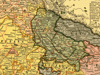
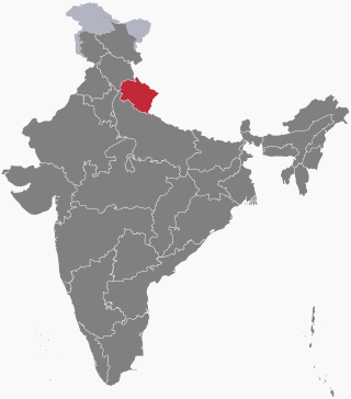
Kumaon is a revenue and administrative division in the Indian State of Uttarakhand. It spans over the eastern half of the state and is bounded on the north by Tibet, on the east by Nepal, on the south by the state of Uttar Pradesh, and on the west by Garhwal. Kumaon comprises six districts of the state: Almora, Bageshwar, Champawat, Nainital, Pithoragarh and Udham Singh Nagar.

<span class="mw-page-title-main">Garhwal division</span> Administrative division in India

Garhwal is one of the two administrative divisions of the Indian state of Uttarakhand. Lying in the Himalayas, it is bounded on the north by Tibet, on the east by Kumaon, on the south by Uttar Pradesh state, and on the northwest by Himachal Pradesh state. It includes the districts of Chamoli, Dehradun, Haridwar, Pauri Garhwal, Rudraprayag, Tehri Garhwal, and Uttarkashi. The people of Garhwal are known as Garhwali and speak the Garhwali language. The administrative center for Garhwal division is the town of Pauri. The Divisional Commissioner is the administrative head of the Division, and is a senior Indian Administrative Service officer. As the administrative head of the division, the Commissioner is overall incharge of the 7 districts in the Garhwal region of Uttarakhand, and is aided in his duties by an additional commissioner and the district magistrates. Sushil Kumar is the divisional commissioner of the Garhwal Division since December 2021.

<span class="mw-page-title-main">Uttarakhand</span> State in northern India

Uttarakhand, formerly known as Uttaranchal, is a state in northern India. The state is divided into two divisions, Garhwal and Kumaon, with a total of 13 districts. The winter capital and largest city of the state is Dehradun, which is also a railhead. On 5 March 2020, Bhararisain, a town in the Gairsain Tehsil of the Chamoli district, was declared as the summer capital of Uttarakhand. The High Court of the state is located in Nainital, but is to be moved to Haldwani in future.

The Panwar dynasty ruled the Garhwal Kingdom. The dynasty independently ruled Garhwal from the ninth to nineteenth century until the Kingdom of Nepal attacked the Kumaon Kingdom in 1791 and Garhwal in 1804. With the help of the British troops, Garhwal and Kumaon gained independence from Nepal. Unable to pay the military cost of British-ruled India, the then-Garhwali king gave part of his territory to the Raj and ruled until 1949. The last king of Garhwal, Manabendra Shah, decided to join India after it became independent. Garhwal and Kumaon became part of India as the then-state of Uttar Pradesh, which is now Uttarakhand.

Gairsain is a town in Chamoli district of the Indian state of Uttarakhand near state's summer capital Bhararisain. A town and Nagar Panchayat, Gairsain is situated at the eastern edge of the vast Dudhatoli mountain range, and is located in Chamoli district almost at the centre of the state, at a distance of approximately 250 kilometres from Dehradun. It is easily accessible from both the Garhwal and the Kumaon divisions, and in a way, acts as the bridge between the two regions. It is being considered as the future Permanent capital of Uttarakhand.

<span class="mw-page-title-main">Pauri Garhwal district</span> District of Uttarakhand in India

Pauri Garhwal is a district in the Indian state of Uttarakhand. Its headquarters is in the town of Pauri. It is sometimes referred to simply as Garhwal district, though it should not be confused with the larger Garhwal region of which it is only a part of.

<span class="mw-page-title-main">Tehri Garhwal district</span> District of Uttarakhand in India

Tehri Garhwal is a district in the hill state of Uttarakhand, India. Its administrative headquarters is at New Tehri. The district has a population of 618, 931, a 2.35% increase over the previous decade. It is surrounded by Rudraprayag District in the east, Dehradun District in the west, Uttarkashi District in the north, and Pauri Garhwal District in the south. Tehri Garhwal is a part of the Himalayas.

<span class="mw-page-title-main">Uttarkashi district</span> District in Uttarakhand, India

Uttarkashi District is a district of Garhwal division of the Uttarakhand state in northern India, and has its headquarters at Uttarkashi city. It has six Tehsils namely Barkot, Dunda, Bhatwadi, Chinyalisaur, Purola and Mori.

<span class="mw-page-title-main">Garhwal District</span>

Garhwal District is a former district in Kumaon of British India of the United Provinces, and had an area of 5,629 sq mi (14,580 km2). It later became a part of the Indian state of Uttar Pradesh, today it is part of the Indian state Uttarakhand.

<span class="mw-page-title-main">Gauchar</span> Town in Uttarakhand, India

Gauchar is a Hill Town sort of a valley town located in Karnaprayag tehsil within Chamoli district of Uttarakhand state in India. Gauchar is situated on the left bank of river Alaknanda and is en route to the celebrated holy destination of Badrinath. It is well known for being one of the cleanest place in country. It has previously topped Swachta sarvekshan best ganga town award. Situated at an altitude of 800 metres (2,620 ft) above the sea level, Gauchar is surrounded by seven mountains. Gauchar is well known for its historic trade fair and airstrip. Gauchar town known for its great work to curb loss of lives in 2013 flood disaster of Uttarakhand. This town is unique in terms of its geographical location and topography. Gauchar is located on one of the largest pieces of flatland in this mountainous region of Uttarakhand. Education institution in Gauchar includes a beautiful Kendriya Vidyalaya adjacent to the main playground.

<span class="mw-page-title-main">Narendra Nagar</span> Town in Uttarakhand, India

Narendranagar is a town and a municipal board in Tehri Garhwal district in the Indian state of Uttarakhand.

Lt. Col. Maharaja Manabendra Shah was a member of the 2nd, 3rd, 4th, 10th, 11th, 12th, 13th and 14th Lok Sabha of India. He represented the Tehri Garhwal constituency of Uttarakhand and was a member of the Indian National Congress before joining the Bharatiya Jan Sangh and later the Bharatiya Janata Party (BJP) political party. He became one of the BJP's longest-serving members. Shah was ambassador to Ireland from 1980 to 1983.

Fateh Shah was the Hindu Rajput king of Garhwal, a small kingdom in North India, from 1684 to 1716.

<span class="mw-page-title-main">History of Uttarakhand</span> State

Uttarakhand is a Himalayan state in North India, nestled between the Tibetan Plateau and the Indo-Gangetic Plains. The name, which means "northern land" or "section" or "northern part" in Sanskrit was made popular in the 80s as part of the wider statehood struggle within the region.

<span class="mw-page-title-main">Garhwali people</span> Indian ethno-linguistic group in the Garhwal region of the Indian state of Uttarakhand

The Garhwali people are an Indian ethnolinguistic group native to the Garhwal, in the Indian state of Uttarakhand, who speak Garhwali, an Indo-Aryan language.

<span class="mw-page-title-main">Kumaon Kingdom</span> Independent Himalayan kingdom (600–1791)

Kumaon Kingdom was an independent Himalayan kingdom in Kumaon, a region located in the eastern part of the present-day Uttarakhand state of India. It was established around 7th century and remained an independent and sovereign kingdom until 1791.

The Uttarakhand movement refers to the events of statehood activism within the undivided state of Uttar Pradesh which ultimately resulted in the formation of Uttarakhand, India as a separate state.

<span class="mw-page-title-main">Outline of Uttarakhand</span> Overview of and topical guide to Uttarakhand

The following outline is provided as an overview of and topical guide to Uttarakhand:

Battle of Khurbura or Battle of Khudbuda also known as Gorkha-Garhwal War occurred in May 1804 near modern-day village of Dehradun, Khurbura 30.3256°N 78.0267°E. The battle is regarded as the first major attack in the history of Garhwal Kingdom that triggered between Kingdom of Nepal forces and Maharaja Pradyumna Shah, and continued for 13 days until the Garhwal king was defeated. It is chiefly regarded the only defeat of Pradyumna Shah's life and the victory of Gorkhali forces under Kingdom of Nepal.

Maharaja Pradyumna Shah or Pradyuman Shah, also known as Pradyumna Chand, was the last and 54th ruler of Garhwal dynasty until the kingdom was independent. He reigned over the state territories from 1785 to 14 May 1804, and later the kingdom was defeated by the Gurkha forces after the Battle of Khurbura occurred near Dehradun.

References

  1. 1 2 "Kingdom that Mughals could never win". The Tribune. 22 February 2016. Archived from the original on 30 January 2018. Retrieved 29 January 2018.
  2. International Cyclopaedia: A Library of Universal Knowledge, Volume 6. Dodd, Mead & Company. 1885. p. 451.
  3. History Archived 10 April 2009 at the Wayback Machine Pauri Garhwal district .
  4. Rawat|Page 15-16.
  5. Garhwal District – History Archived 18 April 2021 at the Wayback Machine The Imperial Gazetteer of India 1909, v. 12, p. 165.
  6. Archived 3 July 2014 at the Wayback Machine Tehri Garhwal official website.
  7. 1 2 Chisholm, Hugh, ed. (1911). "Garhwal"  . Encyclopædia Britannica . Vol. 11 (11th ed.). Cambridge University Press. p. 466.
  8. History Archived 10 April 2009 at the Wayback Machine Uttarkashi district website.
  9. Karnavati Archived 29 May 2016 at the Wayback Machine Garhwal Himalayas: A Study in Historical Perspective, by Ajay S. Rawat. Published by Indus Publishing, 2002. ISBN   81-7387-136-1. Page 43-44.
  10. Dehradun district Archived 22 November 2020 at the Wayback Machine The Imperial Gazetteer of India, 1909 v. 11, p. 212.
  11. Dehradun District – History Archived 23 September 2020 at the Wayback Machine The Imperial Gazetteer of India, 1909, v. 11, p. 213.
  12. Rawat, Ajay S. (November 2002). Garhwal Himalayas: A Study in Historical Perspective. Indus Publishing. ISBN   978-81-7387-136-8. Archived from the original on 31 May 2022. Retrieved 17 November 2021.
  13. "Imperial Gazetteer2 of India, Volume 18, page 324 – Imperial Gazetteer of India – Digital South Asia Library". dsal.uchicago.edu. Archived from the original on 29 November 2019. Retrieved 21 April 2020.
  14. Atkinson, Edwin T. (Edwin Thomas), 1840–1890. (1990). Himalayan Gazetter. Cosmo. OCLC   183008777.{{cite book}}: CS1 maint: multiple names: authors list (link) CS1 maint: numeric names: authors list (link)
  15. Pande, Badri Datt (1993). History of Kumaon (English version of "Kumaon Ka Itihas"). Shyam Prakashan. ISBN   81-900209-4-3. OCLC   833063116.
  16. Mittal, Arun K. (1986). British Administration in Kumaon Himalayas: A Historical Study, 1815–1947. Mittal Publications. Archived from the original on 31 May 2022. Retrieved 17 November 2021.
  17. British Kumaun-Garhwal, Vol. I. p. 5.
  18. Oakley, E. Sherman (1905). Holy Himalaya; the religion, traditions, and scenery of Himalayan province (Kumaon and Garwhal). Oliphant Anderson & Ferrier.
  19. Pradhan 2012, p. 33.
  20. Pradhan 2012, p. 182.
  21. Pradhan 2012, p. 31.
  22. Regmi 1987, p. 159.
  23. Bose, Saikat (June 2015). Boot, Hooves and Wheels: And the Social Dynamics behind South Asian Warfare. Vij Books India Pvt Ltd.
  24. Robert Montgomery Martin, History of the Possessions of the Honourable East India Company, Volume 1, pg. 107
  25. Chisholm, Hugh, ed. (1911). "Tehri"  . Encyclopædia Britannica . Vol. 26 (11th ed.). Cambridge University Press. p. 507.
  26. Tehri – History Archived 23 September 2008 at the Wayback Machine New Tehri Official website.
  27. History Archived 4 December 2008 at the Wayback Machine Narendranagar
  28. Himalayan Spa for Sybarites Archived 31 May 2022 at the Wayback Machine By CELIA W. DUGGER. The New York Times . 30 July 2000.
  29. 1 2 Bansal, Avinash Kumar Singh | Aadhar. "Himotsav | Uniting Culture". himotsav.co.in. Archived from the original on 11 May 2019. Retrieved 5 June 2018.
  30. Rawat, Ajay Singh (2002). Garhwal Himalaya: A Study in Historical Perspective. Indus Publishing Company. p. 22. ISBN   9788173871368.
  31. 1 2 "Manvendra Shah". The Daily Telegraph. 22 April 2007. ISSN   0307-1235. Archived from the original on 25 July 2018. Retrieved 25 July 2018.
  32. "Maharaja's son stakes claim to Tehri". The Indian Express. Archived from the original on 31 May 2022. Retrieved 25 July 2018.
  33. "UP Elections 2017: Tehri maharani fights tradition in politics, aristocracy". dna. 13 February 2017. Archived from the original on 25 July 2018. Retrieved 25 July 2018.

Further reading

30°23′N78°29′E / 30.38°N 78.48°E / 30.38; 78.48