
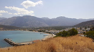
Myrtos is a coastal village in the west of the municipality of Ierapetra, in the Regional Unit of Lasithi on the Greek island of Crete. It is located 50 km (31 mi) from Agios Nikolaos and 15 km (9.3 mi) from Ierapetra, on the road to Viannos. A little to the west of the village is the iconic conical Kolektos mountain. Myrtos is situated on the Libyan Sea. The patron saint of the village is Saint Anthony.
The population of the village in 2010 was approximately 600 people.

Pyrgos is an archaeological site of the Minoan civilization near Myrtos in the municipality of Ierapetra on the south coast of Crete.
Koutsouras (Κουτσουράς) is a village in Lasithi regional unit, in Crete, Greece 22 kilometers east of Ierapetra. Its population is 818. It was the headquarters of the municipality of Makry Gialos and is the biggest village in the region. Key industries include agriculture and tourism. It has nice beaches and a golf course is due to be built over the next five years. The coast is rocky and there are beautiful pebble beaches with crystal clear waters. Today it is the seat of Makry Gialos unity and part of Ierapetra municipality.

Episkopi Ierapetras is a village on the Greek island of Crete. Episkopi belongs to the municipality of Ierapetra in the prefecture of Lasithi. It lies north of Ierapetra in the middle of the narrowest part of the island. The village has approximately one thousand inhabitants.

Anatoli is a small village in the Ierapetra municipality of the prefecture of Lasithi in eastern Crete. It is built 600 meters above sea level and the view over Ierapetra to the sea with Chrysi island opposite, is unique. It is called the "Libyan sea balcony". Despite the destruction of the surrounding wooded area, due to fire in recent years, the whole landscape is fantastic.
Schinokapsala is a community and a small village in Lasithi on Crete. It is situated 21 kilometers north-east from Ierapetra and 6 km from the sea. Since 2011 it belongs to the Ierapetra municipality.
Oreino is a small village in Lasithi regional unit on Crete, Greece. It is situated 28 kilometers northeast of Ierapetra and lies 10 kilometers from the Cretan south coast. Since 2011 it belongs to Ierapetra municipality. It is situated at 650 meters above sea level, east of Thrypti mountain, in an area rich in vegetation.
Males is a historic village in the municipality of Ierapetra in Lasithi prefecture on Crete. It is situated 25 kilometers north-west of Ierapetra, 40 from Agios Nikolaos and 12 kilometers away from the sea. Together with nearby hamlets Hristos and Metaxohori Males until recently formed the Nea Mala municipality. It is built 550 meters above sea level, south east of Dikti mountain, in an area rich in vegetation. It is built where the ancient city of Mala was.
Ano Simi is a village on Crete in the prefecture of Lasithi. It is part of Ierapetra municipality and borders Viannos municipality. It lies about 900 meters above sea level, south of Mount Dikti in what is probably the most wooded area of Crete. It is about 1 kilometer from Kato Simi, and 32 kilometers from Ierapetra.
Leszczany-Kolonia is a village in the administrative district of Gmina Żmudź, within Chełm County, Lublin Voivodeship, in eastern Poland.
Stawki Żytniowskie is a village in the administrative district of Gmina Rudniki, within Olesno County, Opole Voivodeship, in south-western Poland.
Kato Symi is a small historic village of Crete, in Heraklion regional unit, 31 km (19 mi) from Ierapetra and 74 km (46 mi) from Heraklion city. Today it belongs to Viannos municipality and borders the Ierapetra municipality. It lies about 780 m (2,560 ft) above sea level, south of Mount Dikti in a verdant mountainous area, which is probably the most wooded of Crete. Near the village, at an altitude of 1,200 m (3,900 ft), lies the ancient sanctuary of Hermes and Aphrodite. It is dated from the middle Minoan period and had been used for worship for more than 1,000 years. Kato Simi has been destroyed three times, by Arabs, Turks and finally by the German army in World War II, when it was the center of resistance of the Viannos–Ierapetra area against the Nazi occupying forces.
Brant is a hamlet in the town of Brant in Erie County, New York, United States.
Stavrochori is a historic village of eastern Crete. It belonged to the former province of Sitia and later to the former Makry Gialos municipality. Today it is part of Ierapetra municipality. It is located in a wooded valley, 29 kilometers north east from Ierapetra and 35 kilometers southwest from Sitia. Once it was the most populous village of the region and the administrative center of the surrounding settlements. Since the last 30 years, the majority of its population has moved to the seaside settlement of Koutsouras, 7 kilometers to the south. Stavrochori is a traditional village with many sights. It is also the birthplace of Ioannis Papachatzakis or " Stravogiannios ", a violinist, who lived and died in Ierapetra. He was one of the most important Cretan traditional organ players of the last century.
Agios Stefanos is a village within the Lasithi prefecture in eastern Crete. It belonged to the former province of Siteia until that was abolished in 2006. Between 1997 and 2010, it was part of the former Makry Gialos municipality. Today, it is part of Ierapetra municipality. It is located 30 kilometers north-east of Ierapetra, 40 kilometers southwest of Sitia, and six kilometers east of Stavrohori. It can be approached through the famous forest of Pefkoseli. Its patron is Saint Stephen. Saint Stephen church, at the entrance of the village, is an ecclesiastical and historical monument of Crete. Since the last decade, the majority of the population has been moved to the village's seaside settlement of Makry Gialos, some six kilometers to the south. Makry Gialos is one of Crete's most important tourist resorts.
Tanna Fault is a left lateral strike-slip fault which runs along the northeast side of Izu Peninsula south 30 km to Izu City in Japan. It was responsible for the magnitude 7.0 1930 North Izu earthquake (北伊豆地震).

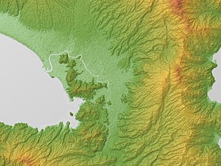
The Isthmus of Ierapetra is the most narrow part of Crete.
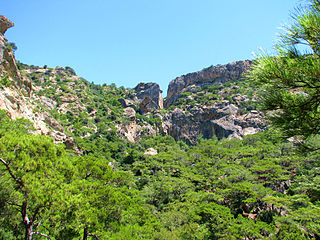
The Milona Gorge is a gorge, situated near the village of Agios Ioannis, in the municipally of Ierapetra in Crete. There is a 10- to 15-minute drive from the town of Ierapetra to the gorge. It has a large waterfall at the end of the walking path.
The walking path is only a 20-minute walk from the road and it is quite easy to follow. At the end of the path, you will find the 40-metre height fall of Milona. The best season to cross the path is in spring, since the waterfall will have plenty water, while in summer, although nice as well it can be much drier.
The beach of Agia Fotia is located 13 kilometers east of Ierapetra, in Crete. It was awarded the Blue Flag in 2006. The village is named after the church of Agia Fotini located here.
Pacheia Ammos is a village in the municipality of Ierapetra on the island of Crete in Greece. It is located on the north coast of the island, 15 km to the north of the city of Ierapetra, at the fork in the road that leads to Heraklion in the west and Sitia in the east.


