Related Research Articles

Ward County is a county in the U.S. state of North Dakota. As of the 2020 census, the population was 69,919, making it the fourth most populous county in North Dakota. Its county seat is Minot. Ward County is part of the Minot, ND Micropolitan Statistical Area.
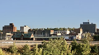
Minot is a city in and the county seat of Ward County, North Dakota, United States, in the state's north-central region. It is most widely known for the Air Force base approximately 15 miles (24 km) north of the city. With a population of 48,377 at the 2020 census, Minot is the state's fourth-most populous city and a trading center for a large part of northern North Dakota, southwestern Manitoba, and southeastern Saskatchewan. Founded in 1886 during the construction of James J. Hill's Great Northern Railway, Minot is also known as "Magic City", commemorating its remarkable growth in size over a short time.

Northwest is the northwestern quadrant of Washington, D.C., the capital of the United States, and is located north of the National Mall and west of North Capitol Street. It is the largest of the four quadrants of the city, and it includes the central business district, the Federal Triangle, and the museums along the northern side of the National Mall, as well as many of the District's historic neighborhoods.

The name "M Street" refers to two major roads in the United States capital of Washington, D.C. Because of the Cartesian coordinate system used to name streets in Washington, the name "M Street" can be used to refer to any east-west street located twelve blocks north or south of the dome of the United States Capitol. Thus, in all four quadrants of the city there are streets called "M Street", which are disambiguated by quadrant designations, namely, M Street NW, NE, SW, and SE.
Minot City Transit, is the public transit agency operated in Minot, North Dakota, It operates fixed-route bus routes in the city.

There are two north–south arteries in Washington, D.C. named 7th Street that are differentiated by the quadrants of the city in which they are located.
The streets and highways of Washington, D.C., form the core of the surface transportation infrastructure in Washington, D.C., the federal capital of the United States. Given that it is a planned city, the city's streets follow a distinctive layout and addressing scheme. There are 1,500 miles (2,400 km) of public roads in the city, of which 1,392 miles (2,240 km) are owned and maintained by city government.
The city of Calgary, Alberta, has a large transportation network that encompasses a variety of road, rail, air, public transit, and pedestrian infrastructure. Calgary is also a major Canadian transportation centre and a central cargo hub for freight in and out of north-western North America. The city sits at the junction between the "Canamex" highway system and the Trans-Canada Highway.

U.S. Route 50 (US 50) is a major east–west route of the U.S. Highway System, stretching just over 3,000 miles (4,800 km) from Ocean City, Maryland, on the Atlantic Ocean, to West Sacramento, California, nearly to the Pacific Ocean. In Washington, D.C., US 50 passes between Arlington County, Virginia, and Prince George's County, Maryland, predominantly along surface streets, including a part of Constitution Avenue along the National Mall.
Transport in Edmonton is fairly typical for a Canadian city of its size, involving air, rail, road and public transit. With very few natural barriers to growth and largely flat to gently rolling terrain bisected by a deep river valley, the city of Edmonton has expanded to cover an area of nearly 768 km2 (297 sq mi), of which only two-thirds is built-up, while the metropolitan area covers around 9,430 km2 (3,640 sq mi).

Downtown Minot is the central business district of Minot, North Dakota, located south of the Souris River in the Souris Valley. Downtown is the site of the first permanent settlement in Minot in 1886. Downtown is home to many of Minot's cultural sites of interest. It is also home to numerous galleries, stores and restaurants. The Minot Riverwalk traverses the downtown.
West Minot is a neighborhood in Minot, North Dakota, located in the Souris River Valley. It borders Oak Park to the South, North Hill to the North, Bel Air to the west and Nubbin Park to the east. The neighborhood is largely residential and there are no commercial thoroughfares, which run through the neighborhood. It received its name when at the time it was the westernmost neighborhood in Minot. Today, there are neighborhoods, such as Bel Air further west of here, but the area has retained the name West Minot. West Minot is home to the Quentin N. Burdick Jobs Center, Minot's Hebrew Cemetery and the West Minot Church of God.

Bel Air is a neighborhood in Minot, North Dakota, located in the Souris River Valley. It is roughly bound by North Hill to the north, Sixteenth Street NW to the east, Fourth Avenue NW to the south and the city limits on the west. The neighborhood was home to about a thousand people in 2010. The neighborhood is home to Bel Air Elementary School on Twenty Fifth Street NW. The neighborhood was developed as the Bel Air Addition in 1956. Fourth Avenue is home to a number of businesses in Bel Air, many of which were severely damaged in the Souris River flood in 2011. Bel Air is home to the Church of the Living God, the Bible Fellowship Church and the Christ Lutheran Church.

North Hill is a neighborhood in Minot, North Dakota, one of three major areas of the city, others being The Valley and South Hill, It is located north of the Souris River, above the Souris River Valley. It is a primarily residential neighborhood, though there are industries and businesses in the area, primarily along North Broadway and 21st Ave NW. North Hill is also home to Minot International Airport.

South Hill is a neighborhood in Minot, North Dakota, one of three major areas in the city, others being North Hill and The Valley, it is located south of the Souris River, above the Souris River Valley. It is a primarily residential neighborhood, although there are commercial zones along South Broadway, 20th Ave SW, 37th Ave SW, and around the Dakota Square Mall.
Upper Brooklyn or Brooklyn Heights is a neighborhood on South Hill in Minot, North Dakota. The neighborhood consists of the sections of the Brooklyn Addition that are not part of Downtown Minot. The High Third neighborhood, the Lower Brooklyn neighborhood and the area around the Minot Municipal Auditorium, which were part of the Brooklyn Addition, are considered part of the downtown area. Upper Brooklyn is bordered by downtown and the BNSF railroad tracks to the north, Minot High School's Magic City Campus to the west, Eleventh Avenue SW to the south and South Broadway and Lower Brooklyn to the east. The neighborhood is approximately 0.46 square kilometers. The neighborhood is home to the Scandinavian Heritage Park and Jim Hill Middle School.
Burnside Street is a major thoroughfare of Portland, in the U.S. state of Oregon, and one of a few east–west streets that runs uninterrupted on both sides of the Willamette River. It serves as the dividing line between North Portland and South Portland. Its namesake bridge, Burnside Bridge, is one of the most heavily traversed in Portland. In Gresham between approximately the east 18300 block to Mt. Hood Hwy, Burnside runs southeast–northwest and is no longer the divide between northeast and southeast on the City of Portland-Multnomah County street grid. Additionally, SE Burnside St becomes NW Burnside Road at SE 202nd/NW Birdsdale Ave, and NE Burnside Rd at N Main Ave in Gresham. Burnside Road's eastern terminus is where it meets Mt. Hood Hwy (US-26), E Powell Blvd (US-26), and SE Powell Valley Road.

16 Avenue N is a major road in Calgary, Alberta, that forms a 26.5-kilometre (16.5 mi) segment of Highway 1 and connects Calgary to Banff and Medicine Hat. It is a four to six-lane principal arterial expressway at its extremities, but is an urban arterial road between the Bow River and Bowness Road, and also between Crowchild Trail and Deerfoot Trail. Due to Calgary's quadrant system, it is known as 16 Avenue NW west of Centre Street and 16 Avenue NE to the east.
References
- ↑ "US Gazetteer files: 2010, 2000, and 1990". United States Census Bureau. 2011-02-12. Retrieved 2011-04-23.