See also
| This disambiguation page lists articles associated with the title Gharghashti. If an internal link led you here, you may wish to change the link to point directly to the intended article. |
It is proposed that this article be deleted because of the following concern:
If you can address this concern by improving, copyediting, sourcing, renaming, or merging the page, please edit this page and do so. You may remove this message if you improve the article or otherwise object to deletion for any reason. Although not required, you are encouraged to explain why you object to the deletion, either in your edit summary or on the talk page. If this template is removed, do not replace it . The article may be deleted if this message remains in place for seven days, i.e., after 23:51, 28 September 2019 (UTC). Find sources: "Gharghashti" disambiguation – news · newspapers · books · scholar · JSTOR |
Another editor has reviewed this page's proposed deletion and endorses both the proposal and the reason given above. If you remove the {{proposed deletion/dated}} tag above, please also remove this {{Proposed deletion endorsed}} tag. |
Gharghashti may refer to:
Ghorghushti is one of the largest towns of Chhachh in Attock District and is on the border of North-West Punjab (Pakistan), and Hazara in Khyber Pakhtunkhwa province. The official spelling is Ghorghushti, but alternative spellings include: Ghurghushti, Ghourghushti, Ghaurghashti, Ghaur Ghushti, Ghurgushti, Ghourgashti or Ghaurghashti. In the Pukhto language it is called Ghorghushto.
Ghurghushto is an administrative unit, known as Union council of Buner District in the Khyber Pakhtunkhwa province of Pakistan.
| This disambiguation page lists articles associated with the title Gharghashti. If an internal link led you here, you may wish to change the link to point directly to the intended article. |

Balochistan is one of the four provinces of Pakistan. It is the largest province in terms of land area, forming the southwestern region of the country, but is the least populated. Its provincial capital and largest city is Quetta.

The Geography of Pakistan is a profound blend of landscapes varying from plains to deserts, forests, hills, and plateaus ranging from the coastal areas of the Arabian Sea in the south to the mountains of the Karakoram range in the north. Pakistan geologically overlaps both with the Indian and the Eurasian tectonic plates where its Sindh and Punjab provinces lie on the north-western corner of the Indian plate while Balochistan and most of the Khyber Pakhtunkhwa lie within the Eurasian plate which mainly comprises the Iranian Plateau. Gilgit-Baltistan and Azad Kashmir lie along the edge of the Indian plate and hence are prone to violent earthquakes where the two tectonic plates collide.

In general, a rural area or countryside is a geographic area that is located outside towns and cities. The Health Resources and Services Administration of the U.S. Department of Health and Human Services defines the word rural as encompassing "...all population, housing, and territory not included within an urban area. Whatever is not urban is considered rural."

Bannu District is a district in Bannu Division of Khyber Pakhtunkhwa province in Pakistan. It was recorded as a district in 1861 during the British Raj. It is one of 26 districts that make up the Khyber Pakhtunkhwa province of Pakistan. It borders North Waziristan to the northwest, Karak to the northeast, Lakki Marwat to the southeast, and South Waziristan to the southwest. It is represented in the provincial assembly by four MPAs.

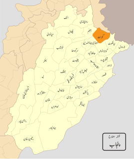
Bahawalpur District is one of the districts of Punjab, Pakistan. Its capital is the city of Bahawalpur. According to the 1998 Census of Pakistan it had a population of 2,433,091, of which 27.01% were urban. Bahawalpur district covers 24,830 km². Approximately two-thirds of the district (16,000 km²) is covered by the Cholistan Desert, which extends into the Thar Desert of India. The district is a major producer of cotton.

Vehari District, , is a district in the Punjab province of Pakistan. The city of Vehari is the capital of the district.
Gujrat, is a district of Punjab Province in Pakistan.

Sukkur district, , is a district in Sindh Province in Pakistan. It is divided into 5 administrative strata (tehsils), namely; Sukkur City, New Sukur, Rohri, Saleh Pat and Pano Aqil. Among them Sukkur city and new Sukkur are urban centre while Pano Aqil is famous for having one of largest military cantonment of the country. Rohri is the smallest tehsil of the Sukkur district, both in area and population but it has an important railway junction. Two districts have been split off from the territory of Sukkur: Shikarpur in 1977 and Ghotki in 1993.

Sargodha District, is a district of Punjab, Pakistan. The capital of the district is Sargodha. It is an agricultural district, wheat, rice, and sugarcane being its main crops. The Sargodha district and region is also famous for citrus fruit including Kinnow, orange and lemon. The district has an area of 5,864 km2.

Dera Ghazi Khan is a district in the Punjab province of Pakistan. Its capital is Dera Ghazi Khan city.

Dera Murad Jamali, often abbreviated as D.M. Jamali, is a city located in Nasirabad District in Balochistan, Pakistan.

Dishu is a district in the south of Helmand Province, Afghanistan, bordering Pakistan. Its population, which is 80% Pashtun and 20% Baloch, was estimated at 19,900 in 2012. The district centre is the village of Dishu; most of the settlements in the district are along the Helmand River. The other important town is Bahramcha.
The Sherpao is a subgroup of the Muhammadzai (Charsadda) tribe. As their name suggests, they are found in the village of Sherpao in the Hashtnagar area of Charsadda District, Pakistan. Sherpao, the common ancestor of the subgroup, was the grandson of Muhammad, the common ancestor of the Muhammadzai tribe. According to Captain Hastings in 1878, the Sherpao had only one high-land hamlet named Dakai, as their other lands were lost to surrounding tribes.
Reg District is situated in the southern part of Kandahar Province, Afghanistan. It borders Helmand Province to the west, Panjwai and Daman districts to the north, Shorabak District to the east and Pakistan to the south. The population is 7,900 (2006). The district center is the village Reg Alaqadari, located in the most southeastern part of the district - a few miles from the international border with Pakistan.
Nika Pani is a village and union council of Mansehra District in Khyber-Pakhtunkhwa province of Pakistan. It is located in the east of the district.
Singapore is an island city-state in Southeast Asia.
The Armenians in Pakistan are ethnic Armenians living in the present country of Pakistan. Armenians have settled various parts of South Asia and many migrated to Karachi during the economic boom in the early 20th century. Notable Armenian settlements in Pakistan can be found in the cities of Karachi, Lahore and in the capital Islamabad.
Ronyal or also referred to as Ronial or Rondyal is a village, situated in the Sebujnei area of Swat Valley's Matta Tehsil, which is an administrative unit of the Swat Valley, known as Union council, of Swat District in the Khyber Pakhtunkhwa province of Pakistan.
The Sanghar are a partly Hindu and partly Muslim community found in the state of Gujarat in India.
Kamdesh District is a district of Nuristan Province in eastern Afghanistan, sharing a name with the town of Kamdesh. It was originally in Kunar Province and then was moved to the newly created Nuristan Province in 2001.