
Edgar County is a county located in the U.S. state of Illinois. As of the 2010 United States Census, the population was 18,576. Its county seat is Paris.
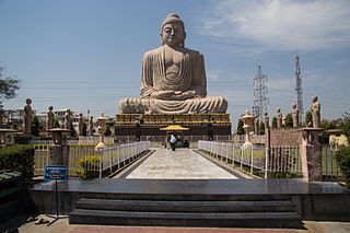
Bodh Gaya is a religious site and place of pilgrimage associated with the Mahabodhi Temple Complex in Gaya district in the Indian state of Bihar. It is famous as it is the place where Gautama Buddha is said to have obtained Enlightenment under what became known as the Bodhi Tree. Since antiquity, Bodh Gaya has remained the object of pilgrimage and veneration for both Hindus and Buddhists.

Gaya is of historical significance and is one of the major tourist attractions of the state of Bihar. Gaya is 100 kilometres (62 mi) south of Patna, the capital city of Bihar. It is the state's second-largest city, with a population of 470,839, and is the headquarters of Gaya district and Magadh division. The city is surrounded on three sides by small, rocky hills, with the Phalgu River on its fourth (eastern) side.

Soroti is the main municipal, commercial, and administrative centre of Soroti District in the Eastern Region of Uganda, lying near Lake Kyoga. It is known for the rock formation near the town.

Moroto is a town in Moroto District in the Northern Region of Uganda. It is the location of the district headquarters.

Masindi is a town in the Western Region of Uganda. It is on the road between Kampala and the Murchison Falls National Park. It is the site of the headquarters of the Masindi District.

Gaya is a city in the Dosso Region of Niger. The city is situated 254 km southeast of the capital, Niamey, is located on the banks of the Niger River, and is near the borders with Benin and Nigeria. Gaya has a population of 28,385. The wettest area in Niger, Gaya averages 800 mm in rainfall a year.

Combolcha Airport is a new airport serving Kombolcha and Dessie in Ethiopia. Construction began in 2010. It replaces the now closed Kombolcha dirt runway airport at 11°4'57"N 39°42'41"E.

Gaya Airport is an airport serving Gaya, Dosso Region, Niger. It is located 2 kilometres west of the city centre.
Kakira is a town in the Eastern Region of Uganda. It is the location of the International headquarters of the Madhvani Group.
Kajjansi is a township in Central Uganda. It is one of the urban centers in Wakiso District.
The Entebbe–Kampala Expressway, also known as the "Kampala–Entebbe Expressway" or the "Entebbe–Kampala Highway", is a four-lane toll highway in the Central Region of Uganda. The highway links Entebbe International Airport, the country's largest civilian and military airport, to Kampala, the country's capital and largest metropolitan area. Commissioning was originally planned for 2016 but because of the delayed works, commissioning was done on 15 June 2018 by Uganda's sitting President, Yoweri Museveni.

Isiolo Airport, also Isiolo International Airport is an airport located in Isiolo, Isiolo County, and Meru County, Kenya.
Nakasongola Airport is an airport in Uganda. As of June 2018, it was one of the 47 airports in the country. It is the headquarters of the Air Wing of the Uganda People's Defense Force and is one of the five national military airports, namely Entebbe Airport, Gulu Airport, Jinja Airport, Soroti Airport and Nakasongola Airport.

Gaya Junction railway station is a junction station serving the city of Gaya, the headquarters of Gaya district and Magadh Division in the Indian state of Bihar. Gaya is in the Mugalsarai Rail Division of the East Central Railway zone. Grand Chord rail-line that connects Howrah and New Delhi passes through Gaya. It lies between Mughalsarai Junction on the Delhi side and Dhanbad Junction on the Howrah side. It is located at 24°48′13″N84°59′57″E. It has an elevation of 117 metres (384 ft). Gaya is connected with most of the states through rail network. Very few trains do-not stop here. There are also two other broad gauge train lines from Gaya, one to Patna and the other to Kiul Junction. The city has major two railway station Gaya Junction & Manpur Junction. Gaya is well connected with Patna, Jehanabad, Biharsharif, Rajgir, Islampur, Nawada through daily passenger and express train services.

Gounou-Gaya Airport is a public use airport located near Gounou-Gaya, Mayo-Kebbi Est, Chad.

