
An acropolis was in ancient Greece a settlement, especially a citadel, built upon an area of elevated ground—frequently a hill with precipitous sides, chosen for purposes of defense. Acropoleis became the nuclei of large cities of classical antiquity, such as ancient Athens, and for this reason they are sometimes prominent landmarks in modern cities with ancient pasts, such as modern Athens.

Denver is the central city of a conurbation region in the U.S. state of Colorado. The conurbation includes one continuous region consisting of the six central counties of Adams, Arapahoe, Broomfield, Denver, Douglas, and Jefferson. The Denver region is part of the Front Range Urban Corridor.

Parliament Hill, colloquially known as The Hill, is an area of Crown land on the southern banks of the Ottawa River in downtown Ottawa, Ontario, Canada. Its Gothic revival suite of buildings is the home of the Parliament of Canada and has architectural elements of national symbolic importance. Parliament Hill attracts approximately 3 million visitors each year. Law enforcement on Parliament Hill and in the parliamentary precinct is the responsibility of the Parliamentary Protective Service (PPS).

Bedford Hills is a hamlet in the Town of Bedford, Westchester County, New York, United States. The population was 3,001 at the 2010 census, which lists the community as a census-designated place. The Bedford Hills Correctional Facility for Women is located in the hamlet.

Royal Air Force Menwith Hill is a Royal Air Force station near Harrogate, North Yorkshire, England, which provides communications and intelligence support services to the United Kingdom and the United States. The site contains an extensive satellite ground station and is a communications intercept and missile warning site. It has been described as the largest electronic monitoring station in the world.
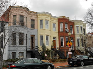
Capitol Hill, in addition to being a metonym for the United States Congress, is the largest historic residential neighborhood in Washington, D.C., stretching easterly in front of the United States Capitol along wide avenues. It is one of the oldest residential neighborhoods in Washington, D.C., and with roughly 35,000 people in just under 2 square miles (5 km2), it is also one of the most densely populated.

The Embassy of the United States of America in Ottawa is the diplomatic mission of the United States of America in Canada. The embassy complex is located at 490 Sussex Drive in Ottawa, Ontario, and it opened in 1999.

RAF Daws Hill was a Ministry of Defence site, located near High Wycombe and Flackwell Heath, in Buckinghamshire, England, close to the M40 motorway.

Timms Hill is the highest natural point in the U.S. state of Wisconsin. Located in north-central Wisconsin in Timms Hill County Park in the Town of Hill in Price County, Timms Hill has an elevation of 1,951.5 ft (595 m). It is less than 1 mile (1.6 km) south of Highway 86, about midway between Ogema and Spirit and about 23 miles (37 km) west of Tomahawk.

Utah Valley is a valley in North Central Utah located in Utah County, and is considered part of the Wasatch Front. It contains the cities of Provo, Orem, and their suburbs, including Alpine, American Fork, Cedar Hills, Elk Ridge, Genola, Goshen, Highland, Lehi, Lindon, Mapleton, Payson, Pleasant Grove, Salem, Santaquin, Saratoga Springs, Spanish Fork, Springville, Vineyard and Woodland Hills. It is known colloquially as "Happy Valley".

The United States House Permanent Select Committee on Intelligence (HPSCI), also known as the House Intelligence Committee, is a committee of the United States House of Representatives, currently chaired by Adam Schiff. It is the primary committee in the U.S. House of Representatives charged with the oversight of the United States Intelligence Community, though it does share some jurisdiction with other committees in the House, including the Armed Services Committee for some matters dealing with the Department of Defense and the various branches of the U.S. military.
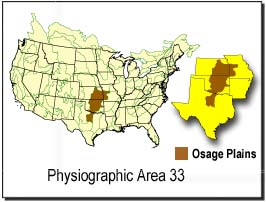
The Osage Plains are a physiographic section of the larger Central Lowland province, which in turn is part of the larger Interior Plains physiographic division. The area is sometimes called the Lower Plains, North Central Plains,or Rolling Plains. The Osage Plains, covering west-central Missouri, the southeastern third of Kansas, most of central Oklahoma, and extending into north-central Texas, is the southernmost of three tallgrass prairie physiographic areas. It grades into savanna and woodland to the east and south, and into shorter, mixed-grass prairie to the west. The Osage Plains consist of three subregions. The Osage Plains proper occupy the northeast segment. Although sharply demarcated from the Ozark uplift, the plains are nonetheless a transitional area across which the boundary between prairie and woodland has shifted over time. In the central portion of the physiographic area lies the second subregion, the Flint Hills, commonly called "the Osage" in Oklahoma. This large remnant core of native tallgrass prairie is a rocky rolling terrain that runs from north to south across Kansas and extends into Oklahoma. To the west and south of these hills are the Blackland Prairies and Cross Timbers. This vegetatively complex region of intermixed prairie and scrubby juniper-mesquite woodland extends into north-central Texas. Bluestem prairies and oak-dominated savannas and woodlands characterize the natural vegetation in the Cross Timbers. Much of the area has been converted to agriculture, although expanses of oak forest and woodland are still scattered throughout the eastern portion of the subregion.

The Black Hills are a small and isolated mountain range rising from the Great Plains of North America in western South Dakota and extending into Wyoming, United States. Black Elk Peak, which rises to 7,244 feet (2,208 m), is the range's highest summit. The Black Hills encompass the Black Hills National Forest. The name "Black Hills" is a translation of the Lakota Pahá Sápa. The hills were so-called because of their dark appearance from a distance, as they were covered in trees.

The form of Massachusetts government is provided by the Constitution of the Commonwealth. The legislative power is exercised by the bicameral General Court, composed of the Senate and House of Representatives. The executive power generally is exercised by the Governor, along with other independently elected officers, the Attorney General, Secretary of the Commonwealth, and Auditor. The judicial power is reposed in the Supreme Judicial Court, which superintends the entire system of courts. Cities and towns also act through local governmental bodies that possess only the authority granted to them by the Commonwealth over local issues, including limited home rule authority. Most county governments were abolished in the 1990s and 2000s, although a handful remain.

Kasubi is a hill in Kampala, Uganda's capital and largest city.

The West Oak Forest Earthlodge Site is a historic site located near Glenwood, Iowa, United States. It was discovered in 2009 by local archeologist Dennis Miller who found a depression of about 20 feet (6.1 m) in diameter, and a maximum depth of 24 inches (61 cm) below the surrounding area. It was authenticated by the Office of the State Archeologist the following year. This is one of 29 known earthlodges that exist from the Nebraska Phase of the Woodland period. The earthlodges were dwellings that were composed of four central support posts, surrounded by shorter outer wall posts, with wattle and daub walls and roof. The depression in the earth was caused by the natural decay and caving-in of the earthlodge itself. In addition to the depression there have been 231 artifacts found at the site that dates from sometime between 1250 and 1400 C.E. The site was listed on the National Register of Historic Places in 2010.

The Glenwood Archeological District is a nationally recognized historic district and archaeological sites located in the vicinity of Glenwood, Iowa, United States. It is one of nine sites from the Nebraska Phase of the Woodland period recognized by archaeologists, and the only one located east of the Missouri River. The district is made up of earth lodge sites, mortuary sites and artifact scatters from the Glenwood culture. They date from sometime between 1250 and 1400 C.E.. The district was listed on the National Register of Historic Places in 2013.


