In the United Kingdom, the term listed building refers to a building or other structure officially designated as being of special architectural, historical, or cultural significance; Grade II* structures are those considered to be "particularly important buildings of more than special interest". [1] Listing was begun by a provision in the Town and Country Planning Act 1947. Once listed, strict limitations are imposed on the modifications allowed to a building's structure or fittings. In Wales, the authority for listing under the Planning (Listed Buildings and Conservation Areas) Act 1990 [2] rests with Cadw.
Name | Location Grid Ref. [note 1] Geo-coordinates | Date Listed | Function | Notes | Reference Number | Image |
---|---|---|---|---|---|---|
Plas-yn-Llan (also known as Plas and Plas Llan) | Eglwysbach SH8017270124 53°12′53″N3°47′45″W / 53.214637774622°N 3.795939590078°W | 31 January 1952 | Located at the SW extremity of the village approximately 250m SE of the village school, and set with its rear against the slope of a hill; accessed via an unmetalled farm track. | 64 | Upload Photo | |
The Pin Mill | Bodnant Garden, Eglwysbach SH7987372248 53°14′01″N3°48′04″W / 53.233652927303°N 3.8012157113742°W | 31 January 1952 | Pin mill | Located to the W of the house at the southern end of the Canal Terrace. | 65 | |
Llaethwryd | Cerrigydrudion SH9404747916 53°01′05″N3°34′51″W / 53.01804028312°N 3.580908151093°W | 23 June 1967 | Farmhouse | The large farm is located S of the Holyhead Road, between the Cwm-penanner road and the minor road running S, and approximately 1400m SW of the village centre. | 72 | Upload Photo |
Church of St Ddoged | Llanddoged, Llanddoged and Maenan SH8059263703 53°09′25″N3°47′14″W / 53.157043135093°N 3.7872520976542°W | 23 June 1967 | Church | Prominently sited in the centre of the village within a raised, circular churchyard with rubble revettment walls. | 91 | |
Church of St Michael | Llanfihangel Glyn Myfyr SH9896749423 53°01′57″N3°30′29″W / 53.032535282942°N 3.508065980714°W | 23 June 1967 | Church | The church stands in a modified oval churchyard, approximately 250m W of Llanfihangel Bridge on the road up the Afon Alwen valley. | 92 | |
Bodtegir Old Farmhouse | Llanfihangel Glyn Myfyr SJ0061448299 53°01′22″N3°28′59″W / 53.022744002743°N 3.4831682304001°W | 23 June 1967 | Farmhouse | Bodtegir is a large farm SE of Llanfihangel, reached by a farm road across open ground from the minor road above the Alwen valley leading to Maerdy and Bettws Gwerful-goch. The old house lies at an angle close to the N side of the present house. | 95 | Upload Photo |
Church of St Digain | Llangernyw SH8751067445 53°11′32″N3°41′07″W / 53.192174150406°N 3.6851587284425°W | 23 June 1967 | Church | 
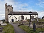
The parish church stands S of the centre of a roughly oval-shaped churchyard on the S side of Llangernyw village centre. The churchyard is entered through a lychgate at W. | 97 | |
Plas Tirion | Bro Garmon SH8104959165 53°06′59″N3°46′43″W / 53.116373492022°N 3.7787355211149°W | 23 June 1967 | House | Prominently and imposingly sited, raised up slightly above the main Llanrwst-Betws-y-Coed road, and set back from it; accessed via a farm track running E from the road and sited across a hillslope. | 109 | Upload Photo |
Hendre Wen | Bro Garmon SH8067258817 53°06′47″N3°47′03″W / 53.113162465823°N 3.7842358899302°W | 23 June 1967 | Farmhouse | Set back from the main Llanrwst to Betws-y-Coed road at the western border of the community and accessed via its own farm track running W from the road; facing a farmyard to the S, behind low rubble forecourt walls. | 110 | Upload Photo |
Cilcennus | Bro Garmon SH8091258310 53°06′31″N3°46′50″W / 53.108660998629°N 3.7804639054741°W | 23 June 1967 | House | Set back from the main road in a prominent raised position on a hill slope; accessed from a lane running SE from the A470 to Capel Garmon. | 112 | Upload Photo |
Cyffdy Hall (including attached Coach House) | Melin-y-Coed, Bro Garmon SH8164760138 53°07′31″N3°46′13″W / 53.125248876115°N 3.7701645818369°W | 23 June 1967 | House | Prominently located on a hillside overlooking the Afon Cyffdy to the E, in its own parkland approximately 1km SE of Melin-y-Coed; accessed via a farm track running SW from the lane running from Melin-y-Coed towards Nebo. | 123 | Upload Photo |
Soflen Farmhouse | Bro Garmon SH8256557196 53°05′56″N3°45′19″W / 53.099019120802°N 3.7553754853503°W | 29 March 1974 | Farmhouse | Located approximately 1.3km NW of Nebo, immediately E of an unclassified lane running NW from Nebo to join the A470. | 140 | Upload Photo |
Parish Church of St Cynfran | Llysfaen SH8932577489 53°16′58″N3°39′41″W / 53.282801117968°N 3.6614976309733°W | 21 June 1950 | Church | Prominently sited in the centre of Llysfaen village at the main cross-roads; located on a commanding site within a circular, rubble-walled graveyard. | 142 | |
St Trillo's Church | Rhos-on-Sea SH8321280639 53°18′35″N3°45′15″W / 53.309788315185°N 3.7543014228752°W | 21 June 1950 | Church | Prominently sited surmounting a mound, in a large grave-yard. | 143 | |
Dinorben Hall | Abergele SH9688274872 53°15′39″N3°32′50″W / 53.260812874808°N 3.5473462947379°W | 6 October 1952 | The farmhouse stands on high land, approximately 150m W of the minor road running S from the village of St George. | 149 | Upload Photo | |
Faerdre | Llanfair Talhaiarn SH9626375442 53°15′57″N3°33′25″W / 53.265813677914°N 3.5568082920715°W | 10 June 1952 | Located on a rise at the NE boundary of the community, approximately 1km SW of the village of St George; accessed via a farm track running NW from Faerdre Hill lane and set behind low rubble enclosing walls. | 150 | Upload Photo | |
Garthewin | Llanfair Talhaiarn SH9151270480 53°13′13″N3°37′35″W / 53.220277211842°N 3.6263181180336°W | 10 June 1952 | Strikingly located within an elevated parkland setting overlooking the Elwy valley 2km W of Llanfair Talhaiarn; accessed via a long metalled drive running NW from the main road. | 158 | ||
Plas Uchaf | Llannefydd SH9669471606 53°13′53″N3°32′57″W / 53.231429638711°N 3.5491029116817°W | 6 October 1952 | 
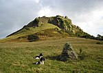
Strikingly-located to the W of, and in the shadow of, the Mynydd y Gaer, approximately 1.5km NW of Llannefydd village; accessed via a farm track running NW from the Llanfair to Llannefydd road, immediately W of the reservoir. | 162 | Upload Photo | |
Berain | Llannefydd SJ0072669728 53°12′55″N3°29′17″W / 53.215324720204°N 3.4881364892129°W | 6 October 1952 | At the foot of a low hill near the cross-roads of the lanes leading from Bont Newydd and Henllan to Llannefydd village; set partly behind low rubble forecourt walls with a partly rock-cut and partly cobbled open courtyard in front. | 163 | Upload Photo | |
Peniarth Fawr | Betws yn Rhos SH9104574261 53°15′15″N3°38′05″W / 53.254154253822°N 3.6346036504062°W | 30 January 1968 | Located 0.5km NE of Betws-yn-Rhos village to the NW of an unclassified lane running NE from Betws towards Abergele; accessed via a farm track and set back slightly behind low rubble forecourt walls. | 170 | Upload Photo | |
Coed Coch | Betws yn Rhos SH8812773970 53°15′03″N3°40′42″W / 53.250931385836°N 3.6782192460725°W | 30 January 1968 | Located in its own parkland setting approximately 0.7km SW of Dolwen; accessed via a long metalled drive running SW from the road. | 172 | ||
Parish Church of St Elian | Llanelian-yn-Rhos, Betws yn Rhos SH8635676428 53°16′22″N3°42′20″W / 53.272638972694°N 3.7056290911811°W | 30 January 1968 | Church | Situated within a raised rubble-walled churchyard on a commanding site in the village centre, with views of the sea to the N. | 177 | |
Llan Farm | Betws yn Rhos SH8635676346 53°16′19″N3°42′20″W / 53.271902223301°N 3.7055997545073°W | 30 January 1968 | Farmhouse | Located in the centre of the village at the main cross-roads with its gable at right-angles to the road; facing a small forecourt with part-enclosing whitened rubble walls. | 178 | Upload Photo |
Plas Llanelian (also known as Plas Ucha) | Betws yn Rhos SH8785875510 53°15′53″N3°40′58″W / 53.264711220898°N 3.6827923376589°W | 30 January 1968 | Located approximately 2km SE of Llanelian-yn-Rhos just beyond Llanelian school, at the end of a narrow lane. | 181 | Upload Photo | |
Parish Church of St Mary | Llanfair Talhaiarn SH9270870135 53°13′03″N3°36′30″W / 53.217420602171°N 3.608296893428°W | 30 January 1968 | Church | Located on an elevated site high above the village centre within a rubble-walled churchyard. | 182 | |
C-shaped Agricultural Complex at Garthewin | Llanfair Talhaiarn SH9145770543 53°13′15″N3°37′38″W / 53.220832024742°N 3.6271629671991°W | 30 January 1968 | Farm buildings | Located to the rear (NW) of Garthewin and enclosing cobbled estate yard on 3 sides. | 185 | Upload Photo |
Plas Newydd | Llanfair Talhaiarn SH9268771530 53°13′48″N3°36′33″W / 53.229950795394°N 3.6090812064228°W | 30 January 1968 | Located on an elevated site approximately 1.5km N of Llanfair village; immediately E of an unclassified lane running N beyond Llanfair from the A 548. | 188 | Upload Photo | |
Former Stable and Coach-house Range at Melai | Llanfair Talhaiarn SH9012367740 53°11′43″N3°38′46″W / 53.195372030817°N 3.6461680328276°W | 30 January 1968 | Stable | Located immediately SE of Melai, facing the house; a cobbled pavement lies in front. | 191 | Upload Photo |
Church of St Sannan | Llansannan SH9340765900 53°10′46″N3°35′47″W / 53.179508571085°N 3.5964179492405°W | 30 January 1968 | Church | Within an irregularly shaped churchyard, set back from the N side of the A544 in the centre of the village of Llansannan. | 212 | |
Plas Isaf | Llansannan SH9582567563 53°11′42″N3°33′39″W / 53.19493127248°N 3.5607948361065°W | 30 January 1968 | Set back slightly from the SE side of the B5382 at the NE end of the small hamlet of Bryn Rhydyrarian. | 213 | Upload Photo | |
Plas Uchaf | Llansanffraid Glan Conwy SH8182575162 53°15′37″N3°46′23″W / 53.260272474468°N 3.7730685527934°W | 30 January 1968 | Located approximately 2.5km SE of Llansanffraid Glan Conwy overlooking the estuary on an elevated W-facing site; accessed via a farm track leading S from the B 5381. | 220 | Upload Photo | |
Tan-yr-Ogof Lodge including adjoining walls and towers to S, E and W | Llanddulas and Rhyd-y-Foel SH9161178052 53°17′18″N3°37′39″W / 53.28833293141°N 3.6274171314216°W | 27 October 1950 | Prominently located on the roadside, some 60m E of the junction with Rhyd-y-Foel Road. | 232 | Upload Photo | |
King's Lodge, also known as Abergele Lodge | Abergele SH9394077555 53°17′04″N3°35′32″W / 53.284339308813°N 3.5923284777641°W | 27 October 1950 | Located at the W end of the town, at the junction of a lane to Tan-y-Gopa and Betws-yn-Rhos. | 233 | Upload Photo | |
Church of St Michael | Abergele SH9454577645 53°17′07″N3°35′00″W / 53.285268908526°N 3.5832873995338°W | 27 October 1950 | Church | 
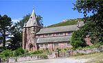
Located in a rectangular churchyard in the angle between Water Street and Market Street, at the centre of the town, and accessed by the short Church Street off Market Street | 237 | |
Morfa Lodge | Abergele SH9836577424 53°17′03″N3°31′33″W / 53.284030680863°N 3.5259394223185°W | 10 April 1973 | Lodge | This outer lodge to Kinmel Park is set at the angle of the Rhuddlan Road and the wooded avenue, Coed-y-drive, running N from the Golden Lodge. | 240 | Upload Photo |
Plas Kinmel | Abergele SH9802776547 53°16′34″N3°31′51″W / 53.276085355584°N 3.5307255673075°W | 10 April 1973 | Plas Kinmel is located on level ground on the E, at the bottom of Primrose Hill, St George. | 243 | Upload Photo | |
Church of St Mary, with churchyard walls | Kinmel Bay and Towyn SH9734279428 53°18′07″N3°32′31″W / 53.301840036788°N 3.5419263856161°W | 10 April 1973 | Church | The church lies immediately E of the Sandbank Road crossroads at the centre of Towyn, enclosed by a rectangular churchyard. | 250 | |
Tŷ'n Llan Nursing Home | Kinmel Bay and Towyn SH9734779460 53°18′08″N3°32′31″W / 53.302128541329°N 3.5418617475529°W | 10 April 1973 | Nursing Home | Located immediately N of the Church of St Mary, with which it is linked. | 251 | |
Towyn and Kinmel Bay Youth Club | Kinmel Bay and Towyn SH9739879456 53°18′08″N3°32′28″W / 53.302102497704°N 3.5410954581299°W | 10 April 1973 | Youth club | One of a group of 3 buildings, set facing the main Rhyl to Abergele Road, immediately E of Sandbank Road at the centre of Towyn. | 252 | Upload Photo |
Gatehouse at Gilar, with attached courtyard walls | Pentrefoelas SH8839349911 53°02′05″N3°39′57″W / 53.034814733016°N 3.6658458093334°W | 23 June 1967 | Gatehouse | 
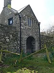
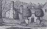
Gilar lies to the S of Rhydlydan, approached by a farm road. The gatehouse is on the N side of the front walled court, with an axial path leading directly to the porch of the E house. | 263 | |
Gilar | Pentrefoelas SH8839349868 53°02′04″N3°39′57″W / 53.034428365386°N 3.6658309131853°W | 31 January 1952 | The group of buildings at Gilar lies apart, to the S of the hamlet of Rhydlydan, and is reached by a minor farm road. | 264 | ||
Pont Ysbyty Ifan | Ysbyty Ifan SH8422148818 53°01′27″N3°43′40″W / 53.0241056889°N 3.727639649248°W | 17 March 1953 | Bridge | Prominently located in the centre of the village and carrying the main road over the Afon Conwy. | 3158 | |
Cymryd | Henryd SH7922875886 53°15′58″N3°48′44″W / 53.266191128027°N 3.8122551132363°W | 17 March 1953 | Strikingly sited on low-lying land on the W bank of the Conwy estuary, at the E boundary of the community; accessed via a long track leading E from Brynseiri Road. | 3159 | Upload Photo | |
Farchwel | Caerhun SH7662370040 53°12′47″N3°50′56″W / 53.213069434301°N 3.8490250470435°W | 13 October 1966 | Prominently located above a bend in the main road (B5106) and set back to the W, approximately 1km SW of Caerhun; accessed via a long metalled track running W from the road. | 3173 | Upload Photo | |
Llanerch-y-Felin | Caerhun SH7590872084 53°13′53″N3°51′38″W / 53.231266072216°N 3.8605219966888°W | 13 October 1966 | Located off the village lane to the N facing its former farmyard, now metalled; accessed via a short metalled lane. | 3175 | Upload Photo | |
Church of St Curig | Capel Curig SH7185257976 53°06′13″N3°54′56″W / 53.103556843115°N 3.9155942176278°W | 13 October 1966 | Church | Situated immediately W of the A 4086 (Capel Curig to Caernarfon road), on the S bank of the Afon Llugwy; approximately 300m NE of Plas-y-Brenin (the National Recreation Centre). | 3178 | |
Pont Gethin | Dolwyddelan SH7797453870 53°04′05″N3°49′22″W / 53.068104773391°N 3.8226425374269°W | 13 October 1966 | Bridge | 
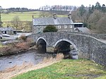
Spanning the Lledr valley dramatically at the western boundary of the community with that of Betws-y-Coed and spanning the A 470 Llanrwst to Dolwyddelan road; partly in Betws-y-Coed community. | 3187 | |
Parish Church of St Peter | Llanbedr-y-Cennin, Caerhun SH7607269567 53°12′31″N3°51′26″W / 53.208691501331°N 3.8570876581594°W | 13 October 1966 | Church | 
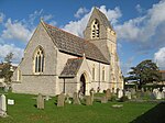
Prominently located on an elevated slope in the centre of the village, approximately 1km W of the Conwy Road (B5106); set within a circular rubble-walled churchyard. | 3203 | |
Parish Church of St. Mary | Trefriw SH7807563221 53°09′08″N3°49′29″W / 53.152141248286°N 3.8246904100013°W | 13 October 1966 | Church | Prominently sited in the town centre within a raised, rubble-walled churchyard; on sloping ground, the W end set into a hill. | 3219 | |
St Michael's Church | Betws-y-Coed SH7960056560 53°05′34″N3°47′58″W / 53.092642959507°N 3.7993962917422°W | 21 June 1950 | Church | Located on the W bank of the Afon Conwy, 100m E of Betws-y-Coed railway station. | 3229 | |
Pont-y-Pair | Betws-y-Coed SH7916256711 53°05′38″N3°48′22″W / 53.093900455816°N 3.8059902468794°W | 21 June 1950 | Bridge | Carrying the B5106 and fording the Afon Llugwy in the centre of the town. | 3230 | |
Toll house at Conwy Suspension Bridge | Conwy SH7830077470 53°16′49″N3°49′36″W / 53.280209521725°N 3.8267681839835°W | 10 August 1981 | Toll house | On the E side of Conwy Suspension Bridge. | 3235 | |
11 Castle Street | Conwy SH7823277604 53°16′53″N3°49′40″W / 53.281397752388°N 3.8278388948088°W | 23 September 1950 | House | A detached building fronting the street. | 3256 | |
Aberconwy House | Conwy SH7819077625 53°16′54″N3°49′43″W / 53.281576751751°N 3.8284765495568°W | 23 September 1950 | House | On the corner of Castle Street and High Street. | 3262 | |
Deganwy Castle | Conwy SH7822379438 53°17′52″N3°49′43″W / 53.297872569468°N 3.8286775764332°W | 23 September 1950 | Castle | Set across 2 steep hills known as The Fardre inland from the village, with panoramic view across Conwy, estuary, coastline and N Wales mountains. | 3365 | |
The Old Cockpit | Conwy SH7805677575 53°16′52″N3°49′50″W / 53.281096678755°N 3.8304660702199°W | 23 September 1950 | Set back from the street and reached by a path to the side of Alfredo Restaurant. | 3367 | ||
Dovecote at Gloddaeth Hall, including attached single-storey blocks | Llandudno SH8035580710 53°18′35″N3°47′50″W / 53.309787238047°N 3.797185209525°W | 16 March 1976 | Dovecote | About 100m E of Hall, to S of former stables. | 3415 | Upload Photo |
Penrhyn Old Hall, including forecourt wall, steps and mounting block | Llandudno SH8155581535 53°19′03″N3°46′46″W / 53.317469576416°N 3.7794926788695°W | 16 March 1976 | Restaurant | On NW side of Penrhyn Old Road, about 250m W of roundabout at bottom of Penrhyn Hill. | 3467 | |
Bryn-y-Neuadd Farmhouse, including attached dairy | Llanfairfechan SH6799174777 53°15′13″N3°58′49″W / 53.253545768524°N 3.9801706361429°W | 14 April 1992 | At E end of grounds of Bryn-y-Neuadd Hospital, reached from Aber Road by driveway almost opposite War Memorial (SH 680 747). At SW corner of farmyard. | 3518 | Upload Photo | |
Church Institute | Llanfairfechan SH6830874796 53°15′14″N3°58′32″W / 53.253795378526°N 3.9754300308058°W | 14 April 1992 | Church Institute | Parallel to road opposite junction with The Close. | 3565 | Upload Photo |
Wern Isaf (formerly Rose Briars) | Llanfairfechan SH6860675109 53°15′24″N3°58′16″W / 53.256681215281°N 3.9710954460887°W | 31 May 1990 | Reached from Park Road along private drive uphill to NE of Llanfairfechan; sited high above Penmaenmawr Road with extensive views over Conwy Bay to Puffin Island and Anglesey. | 3567 | Upload Photo | |
Tŷ Mawr Wybrnant | Bro Machno SH7697952410 53°03′17″N3°50′13″W / 53.054758869008°N 3.8369258490562°W | 13 October 1966 | At head of Wybrnant Valley approx 2.5 km NW of Penmachno. Best reached via signposted minor road branching N off Penmachno-Glasgwm road approx 700m W of Penmachno village centre. | 3578 | ||
Felin Isaf Mill | Pentrefelin, Llansanffraid Glan Conwy SH8028274938 53°15′28″N3°47′46″W / 53.257913383924°N 3.7961035012966°W | 22 December 1975 | Mill | Located below the A 496 on the W side at Pentrefelin; accessed via a short drive from an unclassified road leading W opposite Bont Newydd. | 3630 | Upload Photo |
Grand Theatre | Llandudno SH7912082013 53°19′16″N3°48′58″W / 53.321212593237°N 3.8162079240466°W | 16 March 1976 | Theatre | On corner with Irving Road. | 3633 | |
Church of All Saints | Deganwy, Conwy SH7832979018 53°17′39″N3°49′37″W / 53.294123638101°N 3.8269268891636°W | 24 June 1986 | Church | Set against a steep hillside behind the seafront houses near Deganwy Pier, beyond a short lane off the A546. | 3635 | |
St. Mary's Church | Betws-y-Coed SH7936656449 53°05′30″N3°48′10″W / 53.091592738342°N 3.802847032795°W | 21 January 1988 | Church | Located immediately to the SW of the main road (A5) in the centre of the town. | 3640 | |
Llandudno Pier, including Stone Lodge, Pier End Pavilions, Kiosks and remains of Pier Pavilion | Llandudno SH7835582930 53°19′45″N3°49′41″W / 53.32927541236°N 3.8280385411665°W | 24 March 1969 | Pier | At N end of The Promenade. | 3641 | |
Ysgubor-y-Glyn (adjacent to Capel Curig Training Camp). | Capel Curig SH7508957511 53°06′01″N3°52′02″W / 53.100148360889°N 3.8670908748787°W | 10 April 1990 | Located off the main road to the S, immediately adjacent to the Capel Curig Training Camp, approximately 1km W of the Ty Hyll (Ugly House). | 3647 | Upload Photo | |
Statue of Hercules and pedestal at Gloddaeth Hall | Llandudno SH8027280643 53°18′33″N3°47′54″W / 53.30916649959°N 3.7984049532034°W | 16 March 1976 | Statue | Sited in garden about 50m SE of front of Hall. | 5775 | Upload Photo |
Church of St Hilary | Conwy SH7932580321 53°18′22″N3°48′45″W / 53.306058243161°N 3.8124876683416°W | 1 October 1951 | Church | In a large churchyard N of the main settlement. | 5776 | |
Church of St Tudno | Llandudno SH7697383830 53°20′13″N3°50′57″W / 53.337040881348°N 3.8491281149668°W | 1 October 1951 | Church | On NE slopes of Great Orme, in a hollow known as Pant yr Eglwys. | 5797 | |
Benar farmhouse, including forecourt wall and stairs | Bro Machno SH7942051771 53°02′58″N3°48′01″W / 53.049575029254°N 3.800286668388°W | 13 October 1966 | Farmhouse | On prominent hillside site above Afon Machno to NW of B4406. | 5851 | Upload Photo |
Fedw Deg old farmhouse | Bro Machno SH7891853283 53°03′47″N3°48′30″W / 53.063046035706°N 3.8083404466049°W | 13 October 1966 | Farmhouse | Above Lledr valley reached from forest track at SH 798 539 (near Tan-yr-allt) taking first L and then first R turnings. | 5895 | Upload Photo |
Pen-y-Bryn farmhouse and attached agricultural range | Bro Machno SH7869450294 53°02′10″N3°48′38″W / 53.036140230472°N 3.8105550045332°W | 13 October 1966 | Farmhouse | Above and to NW of road approx 400 metres SW of Penmachno church. House faces roughly SE behind small stone-walled front garden. | 5907 | Upload Photo |
Pen-y-Bryn barn | Bro Machno SH7869950309 53°02′11″N3°48′38″W / 53.036276135655°N 3.8104861252619°W | 13 October 1966 | Barn | To N of and at a right angle to farmhouse. | 5908 | Upload Photo |
Coed-y-Ffynnon | Bro Machno SH8038153028 53°03′40″N3°47′11″W / 53.061085094696°N 3.7864252204292°W | 13 October 1966 | Approx 300m NW of Penmachno Woollen Mill, reached via forestry tracks branching off minor road to SW of Pandy Mill at SH 806 530. | 5918 | Upload Photo | |
St Paul's Church | Colwyn Bay SH8501878828 53°17′38″N3°43′36″W / 53.293913137465°N 3.7265526352573°W | 25 July 1994 | Church | Occupies a block of land at the centre of the town between Woodland Road East and Rhiw Road. | 14657 | |
Christ Church | Bryn-y-Maen, Colwyn Bay SH8362476150 53°16′10″N3°44′47″W / 53.269547652643°N 3.7464747232452°W | 25 July 1994 | Church | Forms the focal point of the small hillside hamlet of Bryn y Maen, approx 3km S of the town. | 14722 | |
Church of Saint John | Old Colwyn SH8694678411 53°17′26″N3°41′51″W / 53.290582124112°N 3.6974920914552°W | 9 September 1994 | Church | On the corner of Station Road and Cliff Road. | 14863 | |
Raised walk at Gwydir Castle | Trefriw SH7988961021 53°07′58″N3°47′48″W / 53.13278830206°N 3.7967536972711°W | 30 May 1996 | Walkway | Listed as a mid-Tudor carved courtyard or garden arch, with associated walls. Additional NG Ref's 27970 36097 to 27988 to 36107 Group value with other listed items at Gwydir Castle. | 16938 | Upload Photo |
Former Oat Kiln at Felin Isaf | Llansanffraid Glan Conwy SH8026074958 53°15′29″N3°47′47″W / 53.258088096639°N 3.7964406481375°W | 1 May 1996 | Oat Kiln | Located immediately to the N of the main and clover mills at Felin Isaf. | 17042 | Upload Photo |
Condover House (formerly Villa Marina) | Llandudno SH8060782259 53°19′26″N3°47′38″W / 53.32376083485°N 3.7939887712534°W | 13 June 1996 | On north (sea) side of Colwyn Road, near W flank of Little Orme. | 17095 | ||
Clover Mill | Llansanffraid Glan Conwy SH8027374945 53°15′29″N3°47′46″W / 53.257974239577°N 3.7962409796363°W | 22 December 1975 | Clover Mill | Located below the A 496 on the W side at Pentrefelin; accessed via a short drive from an unclassified road leading W opposite Bont Newydd. | 17320 | Upload Photo |
Coach-house and Stable Range at Kinmel with terrace walls, steps and archway to E | Abergele SH9814074836 53°15′39″N3°31′43″W / 53.260732855322°N 3.5284829890627°W | 10 June 1970 | Coach house | The stable range extends at right angles, at the S end of the main W elevation of Kinmel, and set above of a series of 3 retained terraces. | 18681 | Upload Photo |
Entrance Screen to the main entrance front at Kinmel | Abergele SH9816974926 53°15′42″N3°31′41″W / 53.26154713224°N 3.5280772460373°W | 8 May 1997 | Screen | The screen encloses the court d'honneur on the E, in front of the E entrance elevation of Kinmel. | 18693 | Upload Photo |
West Range of Farm Buildings at Plas Kinmel | Abergele SH9799476568 53°16′35″N3°31′52″W / 53.276267692629°N 3.5312270115999°W | 8 May 1997 | Farm building | Plas Kinmel stands at the E at the bottom of Primrose Hill, N of St George village. The West Range continues the house to the N enclosing the farmyard on the W. | 18707 | Upload Photo |
North Range of Farmyard Buildings at Plas Kinmel with the enclosed muck yard and entrance gate pier | Abergele SH9802076598 53°16′36″N3°31′51″W / 53.276542268394°N 3.5308468827517°W | 8 May 1997 | Farm building | Plas Kinmel stands at the E at the bottom of Primrose Hill, N of St George village. This north range lies opposite the house and completes the enclosed farmyard. | 18708 | Upload Photo |
East Range of Farmyard Buildings at Plas Kinmel | Abergele SH9804676576 53°16′35″N3°31′50″W / 53.276349595904°N 3.5304500524009°W | 8 May 1997 | Farm building | Plas Kinmel stands at the E at the bottom of Primrose Hill, N of St George village. The East Range encloses the large stock yard of which the house forms the SW corner. | 18709 | Upload Photo |
Piggery at Plas Kinmel | Abergele SH9806876560 53°16′34″N3°31′48″W / 53.276210064874°N 3.5301151152262°W | 8 May 1997 | Farm building | Plas Kinmel stands at the E at the bottom of Primrose Hill, N of St George village. The piggery lies on the E side of the E range of the farmyard, and behind the dovecote at the end of the S range. | 18710 | Upload Photo |
Hendre-fawr | Abergele SH9634076905 53°16′44″N3°33′22″W / 53.278974426315°N 3.556131771003°W | 8 May 1997 | Located on fertile drained flat lands between Abergele and Rhuddlan, and accessed by a farm road, 1m E of Abergele. | 18713 | Upload Photo | |
Parish Church of St Cynbryd | Llanddulas and Rhyd-y-Foel SH9085478211 53°17′23″N3°38′20″W / 53.289605914835°N 3.6388225633231°W | 11 December 1997 | Church | Located in the centre of the village on the north bank of the Afon Dulas, within its own large, rubble-walled churchyard. | 19024 | |
Hen Wrych Lodge including adjoining crenellated boundary walls and towers | Llanddulas and Rhyd-y-Foel SH9280878076 53°17′20″N3°36′34″W / 53.28879246365°N 3.6094767578845°W | 11 December 1990 | Lodge | Facing the road at the eastern boundary of the community, approximately 600m NE of Gwrych Castle | 19039 | Upload Photo |
Plas Tan-yr-Ogof including adjoining walls and arches to E and W | Llanddulas and Rhyd-y-Foel SH9163478074 53°17′19″N3°37′37″W / 53.28853531501°N 3.6270797721053°W | 11 December 1997 | House | Located on the roadside approximately 80m E of the junction with Rhyd-y-Foel Road. | 19040 | Upload Photo |
Tan-yr-Ogof Farmhouse including adjoining arch and walls to E | Llanddulas and Rhyd-y-Foel SH9167878069 53°17′19″N3°37′35″W / 53.288499400659°N 3.6264183063335°W | 11 December 1997 | Farmhouse | Located on the roadside approximately 100m E of the junction with Rhyd-y-Foel Road. | 19041 | Upload Photo |
L-shaped Agricultural Range at Berain | Llannefydd SJ0071469767 53°12′56″N3°29′18″W / 53.215672920024°N 3.4883282791981°W | 15 May 1998 | Farm building | Located immediately NW of Berain, partly enclosing a large farmyard. | 19855 | Upload Photo |
Voelas | Pentrefoelas SH8498651540 53°02′55″N3°43′02″W / 53.048728295785°N 3.7172114592914°W | 19 October 1998 | House | Voelas Estate lies on the W edge of the community, W of Pentrefoelas. The house stands in its own parkland overlooking the picturesque narrow valley of the Afon Conwy. | 20585 | Upload Photo |
Old House and attached Cartshed block at Cysulog | Llangwm SJ0099845106 52°59′39″N3°28′35″W / 52.9941225388°N 3.4764655588888°W | 20 May 2003 | House | Cysulog is about 1 km north of Maerdy. The Old House and Cartshed block is to the NW of the present house. | 80944 | Upload Photo |
In the United Kingdom, the term listed building refers to a building or other structure officially designated as being of special architectural, historical, or cultural significance; Grade I structures are those considered to be "buildings of exceptional interest". Listing was begun by a provision in the Town and Country Planning Act 1947. Once listed, strict limitations are imposed on the modifications allowed to a building's structure or fittings. In Wales, the authority for listing under the Planning Act 1990 rests with Cadw.
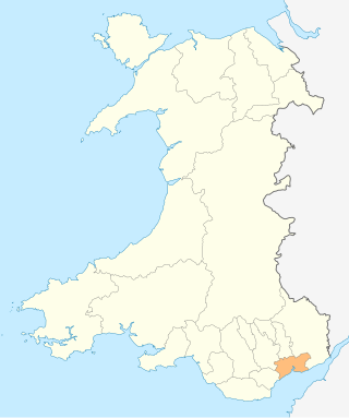
Merthyr Tydfil County Borough is located in the historic county of Glamorgan in Wales and takes its name from its largest town. The county borough covers an area of 111 km2 (43 sq mi) and had a population of approximately 58,900 in 2021.
In the United Kingdom, the term listed building refers to a building or other structure officially designated as being of special architectural, historical, or cultural significance; Grade I structures are those considered to be "buildings of exceptional interest". Listing was begun by a provision in the Town and Country Planning Act 1947. Once listed, strict limitations are imposed on the modifications allowed to a building's structure or fittings. In Wales, the authority for listing under the Planning Act 1990 rests with Cadw.
In the United Kingdom, the term listed building refers to a building or other structure officially designated as being of special architectural, historical, or cultural significance; Grade II* structures are those considered to be "particularly important buildings of more than special interest". Listing was begun by a provision in the Town and Country Planning Act 1947. Once listed, strict limitations are imposed on the modifications allowed to a building's structure or fittings. In Wales, the authority for listing under the Planning Act 1990 rests with Cadw.
In the United Kingdom, the term listed building refers to a building or other structure officially designated as being of special architectural, historical, or cultural significance; Grade II structures are those considered to be "buildings of special interest which justify every effort being made to preserve them". Listing was begun by a provision in the Town and Country Planning Act 1947. Once listed, strict limitations are imposed on the modifications allowed to a building's structure or fittings. In Wales, the authority for listing under the Planning Act 1990 rests with Cadw.
Media related to Grade II* listed buildings in Conwy County Borough at Wikimedia Commons